
– Lat/Long: 35.80° N 82.96° W
 Max Patch
Weather Forecast, United StatesIssued: 7 am Mon 03 Aug Local TimeUpdates in: hr min sUpdate imminent
Issued: 7 am Mon 03 Aug Local Time
Updates in:
Update imminent hr min s

Issued: 7 am Mon 03 Aug Local Time
Updates in:
Update imminent hr min s
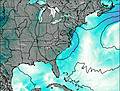
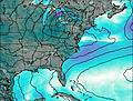
Days 1–3 Weather SummaryHeavy rain (total 22mm), heaviest during Tue afternoon. Warm (max 20°C on Tue afternoon, min 16°C on Mon morning). Wind will be generally light. | Days 4–6 Weather SummaryHeavy rain (total 27mm), heaviest during Sat afternoon. Warm (max 21°C on Fri afternoon, min 19°C on Thu morning). Wind will be generally light. | |||||||||||||||||
Monday 3 | Tuesday 4 | Wednesday 5 | Thursday 6 | Friday 7 | Saturday 8 | |||||||||||||
AM | PM | night | AM | PM | night | AM | PM | night | AM | PM | night | AM | PM | night | AM | PM | night | |
rain shwrs | risk tstorm | risk tstorm | rain shwrs | risk tstorm | rain shwrs | rain shwrs | risk tstorm | risk tstorm | rain shwrs | risk tstorm | risk tstorm | rain shwrs | risk tstorm | risk tstorm | clear | mod. rain | risk tstorm | |
Cloud base (m) | 1800 | 1800 | 2900 | 2650 | 2150 | 9450 | 2050 | 5450 | 5150 | 7350 | 1000 | 6200 | 2200 | 4700 | 6050 | 900 | 5600 | |
km/h | ||||||||||||||||||
 |  |  |  |  |  | |||||||||||||
— | — | — | — | — | — | — | — | — | — | — | — | — | — | — | — | — | — | |
mm | 0.7 | 4 | 2 | 0.1 | 5 | 1.9 | 2 | 5 | 1.5 | 0.9 | 7 | 2 | 0.2 | 4 | 4 | — | 8 | 1.1 |
max °C | 16 | 18 | 18 | 19 | 20 | 19 | 18 | 20 | 19 | 19 | 20 | 20 | 20 | 21 | 20 | 20 | 21 | 20 |
min °C | 16 | 17 | 18 | 18 | 19 | 18 | 18 | 19 | 19 | 19 | 20 | 19 | 19 | 20 | 19 | 19 | 19 | 20 |
chill °C | 16 | 17 | 18 | 18 | 19 | 18 | 18 | 19 | 19 | 19 | 20 | 19 | 19 | 20 | 19 | 19 | 19 | 20 |
Freezing level m | 4500 | 4600 | 4450 | 4550 | 4550 | 4600 | 4550 | 4700 | 4700 | 4650 | 4650 | 4800 | 4600 | 4700 | 4700 | 4600 | 4700 | 4650 |
6:39 | — | — | 6:41 | — | — | 6:41 | — | — | 6:43 | — | — | 6:43 | — | — | 6:43 | — | — | |
— | — | 8:34 | — | — | 8:32 | — | — | 8:31 | — | — | 8:30 | — | — | 8:30 | — | — | 8:29 | |
Loading...
Max Patch Weather (Days 0-3):
The weather forecast for Max Patch is: Heavy rain (total 22mm), heaviest during Tue afternoon. Warm (max 20°C on Tue afternoon, min 16°C on Mon morning). Wind will be generally light.
Max Patch Weather (Days 3-6):
Heavy rain (total 27mm), heaviest during Sat afternoon. Warm (max 21°C on Fri afternoon, min 19°C on Thu morning). Wind will be generally light.
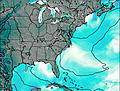
This table gives the weather forecast for Max Patch at the specific elevation of 1411 m. Our advanced weather models allow us to provide distinct weather forecasts for several elevations of Max Patch. To see the weather forecasts for the other elevations, use the tab navigation above the table. For a wider overview of the weather, consult the Weather Map of North-Carolina.
Max Patch Photos
View all
Great Smoky Mountains photos (57) |
Appalachians photos (910) |
photos from mountains in United States (3056) |
all photos
 Upload new photo


 See 16 more Max Patch photos
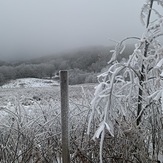
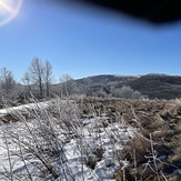
Subzero Sunrise
Max Patch Winter Snow
Max patch during snow storm
View to the east
Icy
Views of buckeye ridge
Buckeye ridge