
– Lat/Long: 43.56° S 170.30° E
 Malte Brun
Weather Forecast, New ZealandIssued: 5 am Tue 04 Aug Local TimeUpdates in: hr min sUpdate imminent
Issued: 5 am Tue 04 Aug Local Time
Updates in:
Update imminent hr min s

Issued: 5 am Tue 04 Aug Local Time
Updates in:
Update imminent hr min s
Days 1–3 Weather SummaryMostly dry. Temperatures will be well below freezing (max -7°C on Thu afternoon, min -16°C on Tue morning). Winds decreasing (stormy winds from the S on Tue morning, calm by Thu afternoon). | Days 4–6 Weather SummaryA heavy fall of snow, heaviest during Fri morning. Temperatures will be well below freezing (max -8°C on Fri morning, min -11°C on Sat night). Winds decreasing (near gales from the NW on Fri morning, calm by Sun afternoon). | |||||||||||||||||
Tuesday 4 | Wednesday 5 | Thursday 6 | Friday 7 | Saturday 8 | Sunday 9 | |||||||||||||
AM | PM | night | AM | PM | night | AM | PM | night | AM | PM | night | AM | PM | night | AM | PM | night | |
clear | clear | clear | clear | clear | some clouds | clear | clear | some clouds | light snow | light snow | some clouds | light snow | mod. snow | snow shwrs | some clouds | some clouds | clear | |
Cloud base (m) | 1850 | 1750 | 6800 | 6600 | 8150 | 1600 | 1700 | 1000 | 1550 | 1000 | 1500 | 1500 | 1650 | 1600 | 1800 | |||
km/h | ||||||||||||||||||
 |  |  |  |  |  | |||||||||||||
— | — | — | — | — | — | — | — | — | 5 | 2 | — | 4 | 6 | 4 | — | — | — | |
mm | — | — | — | — | — | — | — | — | — | — | — | — | — | — | — | — | — | — |
max °C | -13 | -11 | -10 | -10 | -10 | -9 | -8 | -7 | -7 | -8 | -9 | -9 | -9 | -10 | -10 | -10 | -10 | -8 |
min °C | -16 | -12 | -11 | -10 | -10 | -10 | -8 | -7 | -8 | -9 | -10 | -10 | -9 | -10 | -11 | -11 | -10 | -10 |
chill °C | -33 | -26 | -22 | -16 | -17 | -17 | -14 | -10 | -17 | -21 | -21 | -19 | -16 | -14 | -17 | -15 | -10 | -14 |
Freezing level m | 0 | 450 | 0 | 750 | 1100 | 600 | 850 | 1150 | 600 | 1350 | 1650 | 1650 | 1600 | 1650 | 1550 | 1400 | 1600 | 1100 |
7:48 | — | — | 7:48 | — | — | 7:47 | — | — | 7:45 | — | — | 7:43 | — | — | 7:43 | — | — | |
— | 5:39 | — | — | 5:40 | — | — | 5:42 | — | — | 5:43 | — | — | 5:45 | — | — | 5:45 | — | |
Loading...
Malte Brun Weather (Days 0-3):
The weather forecast for Malte Brun is: Mostly dry. Temperatures will be well below freezing (max -7°C on Thu afternoon, min -16°C on Tue morning). Winds decreasing (stormy winds from the S on Tue morning, calm by Thu afternoon).
Malte Brun Weather (Days 3-6):
A heavy fall of snow, heaviest during Fri morning. Temperatures will be well below freezing (max -8°C on Fri morning, min -11°C on Sat night). Winds decreasing (near gales from the NW on Fri morning, calm by Sun afternoon).
This table gives the weather forecast for Malte Brun at the specific elevation of 3198 m. Our advanced weather models allow us to provide distinct weather forecasts for several elevations of Malte Brun. To see the weather forecasts for the other elevations, use the tab navigation above the table. For a wider overview of the weather, consult the Weather Map of New Zealand.
Malte Brun Photos
View all
Southern Alps photos (37) |
New Zealand photos (156) |
photos from mountains in New Zealand (160) |
all photos
 Upload new photo
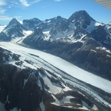
Malte Brun (mountain)