– Lat/Long: 39.43° N 21.15° E
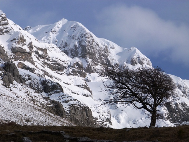
 Katafidhi
Weather Forecast, GreeceIssued: 8 pm Mon 03 Aug Local TimeUpdates in: hr min sUpdate imminent
Issued: 8 pm Mon 03 Aug Local Time
Updates in:
Update imminent hr min s

Issued: 8 pm Mon 03 Aug Local Time
Updates in:
Update imminent hr min s
Days 1–4 Weather SummaryMostly dry. Very mild (max 15°C on Tue afternoon, min 13°C on Mon night). Wind will be generally light. | Days 5–7 Weather SummaryMostly dry. Very mild (max 17°C on Sat afternoon, min 14°C on Thu night). Wind will be generally light. | |||||||||||||||
Tuesday 4 | Wednesday 5 | Thursday 6 | Friday 7 | Saturday 8 | ||||||||||||
night | AM | PM | night | AM | PM | night | AM | PM | night | AM | PM | night | AM | PM | night | |
clear | clear | rain shwrs | clear | some clouds | some clouds | clear | some clouds | cloudy | some clouds | some clouds | cloudy | clear | clear | some clouds | some clouds | |
Cloud base (m) | 3600 | 4500 | 4150 | 4200 | 4000 | 4050 | 4500 | 3950 | ||||||||
km/h | ||||||||||||||||
 |  |  |  |  |  | |||||||||||
— | — | — | — | — | — | — | — | — | — | — | — | — | — | — | — | |
mm | — | — | 0.1 | — | — | — | — | — | — | — | — | — | — | — | — | — |
max °C | 13 | 14 | 15 | 14 | 15 | 15 | 15 | 15 | 15 | 14 | 15 | 15 | 15 | 16 | 17 | 17 |
min °C | 13 | 13 | 14 | 13 | 14 | 15 | 14 | 14 | 14 | 14 | 14 | 14 | 15 | 15 | 17 | 16 |
chill °C | 13 | 12 | 14 | 13 | 14 | 15 | 14 | 13 | 14 | 14 | 14 | 14 | 14 | 14 | 17 | 16 |
Freezing level m | 4350 | 4250 | 4350 | 4400 | 4350 | 4450 | 4450 | 4350 | 4400 | 4350 | 4400 | 4500 | 4700 | 4550 | 4750 | 4650 |
— | 6:37 | — | — | 6:37 | — | — | 6:39 | — | — | 6:39 | — | — | 6:39 | — | — | |
— | — | 8:45 | — | — | 8:44 | — | — | 8:43 | — | — | 8:42 | — | — | 8:39 | — | |
Loading...
Katafidhi Weather (Days 0-3):
The weather forecast for Katafidhi is: Mostly dry. Very mild (max 15°C on Tue afternoon, min 13°C on Mon night). Wind will be generally light.
Katafidhi Weather (Days 3-6):
Mostly dry. Very mild (max 17°C on Sat afternoon, min 14°C on Thu night). Wind will be generally light.
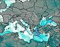
This table gives the weather forecast for Katafidhi at the specific elevation of 2393 m. Our advanced weather models allow us to provide distinct weather forecasts for several elevations of Katafidhi. To see the weather forecasts for the other elevations, use the tab navigation above the table. For a wider overview of the weather, consult the Weather Map of Greece.
| Weather Station | Temp. | Weather | Wind | Gusts | Cloud / Visibility |
|---|---|---|---|---|---|
Ioannina | |||||
Prevez / ktion Airport | |||||
ERSEKA | |||||
Kozani Airport | |||||
* NOTE: not all weather observatories update at the same frequency which is the reason why some locations may show data from stations that are further away than known closer ones.
Katafidhi Photos
View all
Pindos photos (114) |
Balkan Peninsula photos (1075) |
photos from mountains in Greece (690) |
all photos
 Upload new photo
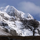
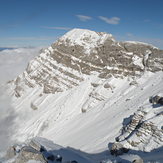
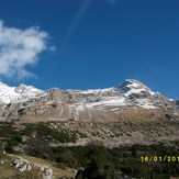
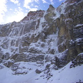

Katafidhi
Katafidhi
tzumerka katafidi 2393m
Τζουμέρκα
tzumerka katafidi 2393m