
– Lat/Long: 27.70° N 88.15° E
 Kangchenjunga
Weather Forecast, NepalIssued: 10 pm Mon 13 Jul Local TimeUpdates in: hr min sUpdate imminent
Issued: 10 pm Mon 13 Jul Local Time
Updates in:
Update imminent hr min s

Issued: 10 pm Mon 13 Jul Local Time
Updates in:
Update imminent hr min s
Days 1–4 Weather SummaryA heavy fall of snow, heaviest during Mon night. Temperatures will be below freezing (max -5°C on Mon night, min -7°C on Wed morning). Wind will be generally light. | Days 5–7 Weather SummaryA heavy fall of snow, heaviest during Sun afternoon. Temperatures will be below freezing (max -5°C on Thu night, min -6°C on Thu night). Wind will be generally light. | ||||||||||||||||||
Tuesday 14 | Wednesday 15 | Thursday 16 | Friday 17 | Saturday 18 | Sunday 19 | ||||||||||||||
night | AM | PM | night | AM | PM | night | AM | PM | night | AM | PM | night | AM | PM | night | AM | PM | night | |
heavy snow | mod. snow | light snow | some clouds | snow shwrs | light snow | snow shwrs | snow shwrs | light snow | snow shwrs | snow shwrs | snow shwrs | snow shwrs | light snow | mod. snow | snow shwrs | snow shwrs | heavy snow | snow shwrs | |
km/h | |||||||||||||||||||
 |  |  |  |  |  |  | |||||||||||||
11 | 7 | 2 | — | 1 | 2 | 1 | 1 | 2 | 2 | 2 | 2 | 1 | 2 | 10 | 11 | 3 | 13 | 6 | |
mm | — | — | — | — | — | — | — | — | — | — | — | — | — | — | — | — | — | — | — |
max °C | -5 | -6 | -5 | -6 | -6 | -5 | -6 | -6 | -5 | -5 | -6 | -5 | -6 | -5 | -5 | -5 | -6 | -6 | -6 |
min °C | -6 | -6 | -6 | -6 | -7 | -5 | -6 | -6 | -5 | -6 | -6 | -5 | -6 | -6 | -5 | -6 | -6 | -6 | -7 |
chill °C | -11 | -10 | -10 | -6 | -13 | -8 | -9 | -9 | -10 | -8 | -6 | -10 | -12 | -10 | -5 | -6 | -8 | -6 | -14 |
Freezing level m | 5900 | 5900 | 6000 | 5900 | 5950 | 6100 | 5950 | 6000 | 6100 | 6000 | 6050 | 6050 | 5900 | 6100 | 6050 | 5900 | 6050 | 5950 | 5750 |
Cloud base (m) | 5500 | 5500 | 5500 | 5550 | 5550 | 5500 | 5500 | 5650 | 5550 | 5500 | 5500 | 5550 | 5500 | 5500 | 5500 | 5500 | 5500 | 5500 | 5500 |
— | 4:50 | — | — | 4:50 | — | — | 4:50 | — | — | 4:52 | — | — | 4:52 | — | — | 4:52 | — | — | |
— | — | 6:35 | — | — | 6:35 | — | — | 6:34 | — | — | 6:34 | — | — | 6:34 | — | — | 6:32 | — | |
Loading...
Kangchenjunga Weather (Days 0-3):
The weather forecast for Kangchenjunga is: A heavy fall of snow, heaviest during Mon night. Temperatures will be below freezing (max -5°C on Mon night, min -7°C on Wed morning). Wind will be generally light.
Kangchenjunga Weather (Days 3-6):
A heavy fall of snow, heaviest during Sun afternoon. Temperatures will be below freezing (max -5°C on Thu night, min -6°C on Thu night). Wind will be generally light.
This table gives the weather forecast for Kangchenjunga at the specific elevation of 7000 m. Our advanced weather models allow us to provide distinct weather forecasts for several elevations of Kangchenjunga. To see the weather forecasts for the other elevations, use the tab navigation above the table. For a wider overview of the weather, consult the Weather Map of Nepal.
| Weather Station | Temp. | Weather | Wind | Gusts | Cloud / Visibility |
|---|---|---|---|---|---|
Baghdogra (in-af | |||||
Tingri | |||||
* NOTE: not all weather observatories update at the same frequency which is the reason why some locations may show data from stations that are further away than known closer ones.
Kangchenjunga Photos
View all
Sikkim-Eastern Nepal Himalaya photos (5) |
Greater Himalaya photos (378) |
photos from mountains in Nepal (292) |
all photos
 Upload new photo
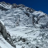
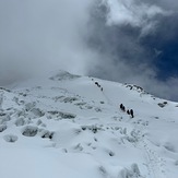
Kangchenjunga Expedition 2025
Kangchenjunga Expedition 2025
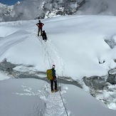
Crossing crevasse above c2
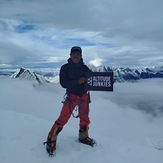
Altitude junkies Kangchenjunga expedition 2025