– Lat/Long: 47.75° N 12.37° E
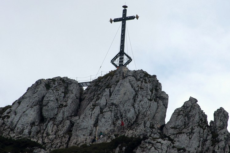
 Kampenwand
Weather Forecast, GermanyIssued: 7 pm Tue 14 Jul Local TimeUpdates in: hr min sUpdate imminent
Issued: 7 pm Tue 14 Jul Local Time
Updates in:
Update imminent hr min s

Issued: 7 pm Tue 14 Jul Local Time
Updates in:
Update imminent hr min s
Days 1–4 Weather SummaryModerate rain (total 18mm), heaviest on Fri afternoon. Warm (max 20°C on Thu night, min 11°C on Tue night). Wind will be generally light. | Days 5–7 Weather SummaryHeavy rain (total 25mm), heaviest during Fri night. Very mild (max 16°C on Fri night, min 10°C on Sun night). Winds decreasing (fresh winds from the W on Sat morning, calm by Sun morning). | ||||||||||||||||||
Wednesday 15 | Thursday 16 | Friday 17 | Saturday 18 | Sunday 19 | Monday 20 | ||||||||||||||
night | AM | PM | night | AM | PM | night | AM | PM | night | AM | PM | night | AM | PM | night | AM | PM | night | |
risk tstorm | some clouds | rain shwrs | risk tstorm | rain shwrs | some clouds | rain shwrs | light rain | rain shwrs | mod. rain | risk tstorm | risk tstorm | risk tstorm | rain shwrs | risk tstorm | risk tstorm | rain shwrs | some clouds | light rain | |
km/h | |||||||||||||||||||
 |  |  |  |  |  |  | |||||||||||||
— | — | — | — | — | — | — | — | — | — | — | — | — | — | — | — | — | — | — | |
mm | 5 | — | 1 | 1.4 | 0.1 | — | 0.1 | 3 | 7 | 6 | 1.5 | 4 | 3 | 0.3 | 4 | 6 | 0.1 | — | 0.7 |
max °C | 17 | 14 | 17 | 17 | 15 | 19 | 20 | 16 | 19 | 16 | 13 | 12 | 13 | 14 | 13 | 11 | 11 | 12 | 11 |
min °C | 11 | 14 | 16 | 13 | 14 | 18 | 19 | 14 | 15 | 14 | 12 | 12 | 12 | 13 | 12 | 10 | 10 | 12 | 9 |
chill °C | 8 | 14 | 16 | 12 | 13 | 18 | 19 | 13 | 14 | 12 | 9 | 10 | 10 | 13 | 11 | 8 | 9 | 11 | 9 |
Freezing level m | 3900 | 3750 | 4000 | 4050 | 4000 | 4150 | 4450 | 4150 | 3950 | 3950 | 3650 | 3700 | 3550 | 3400 | 3500 | 3150 | 3000 | 3200 | 3000 |
Cloud base (m) | 1850 | 3150 | 2900 | 2950 | 9700 | 2650 | 4550 | 2350 | 1600 | 1850 | 3350 | 1700 | 2700 | 1900 | |||||
— | 5:26 | — | — | 5:28 | — | — | 5:28 | — | — | 5:30 | — | — | 5:31 | — | — | 5:31 | — | — | |
— | — | — | 9:05 | — | — | 9:04 | — | — | 9:02 | — | — | 9:01 | — | — | 9:00 | — | — | 9:00 | |
Loading...
Kampenwand Weather (Days 0-3):
The weather forecast for Kampenwand is: Moderate rain (total 18mm), heaviest on Fri afternoon. Warm (max 20°C on Thu night, min 11°C on Tue night). Wind will be generally light.
Kampenwand Weather (Days 3-6):
Heavy rain (total 25mm), heaviest during Fri night. Very mild (max 16°C on Fri night, min 10°C on Sun night). Winds decreasing (fresh winds from the W on Sat morning, calm by Sun morning).
This table gives the weather forecast for Kampenwand at the specific elevation of 1668 m. Our advanced weather models allow us to provide distinct weather forecasts for several elevations of Kampenwand. To see the weather forecasts for the other elevations, use the tab navigation above the table. For a wider overview of the weather, consult the Weather Map of Germany.
| Weather Station | Temp. | Weather | Wind | Gusts | Cloud / Visibility |
|---|---|---|---|---|---|
thunderstorm affecting Aschau im Chiemgau | |||||
thunderstorm affecting Frasdorf | |||||
lightning 5km WSW of Prien am Chiemsee | |||||
Mittelstation Kössen | |||||
Kössen Gipfel | |||||
Hochfelln Süd | |||||
thunderstorm affecting Rohrdorf | |||||
lightning 4km SW of Bad Endorf | |||||
lightning 4km N of Altenmarkt | |||||
lightning 4km N of Raubling |
* NOTE: not all weather observatories update at the same frequency which is the reason why some locations may show data from stations that are further away than known closer ones.
Kampenwand Photos
View all
Bavarian Alps photos (63) |
Alps photos (1484) |
photos from mountains in Germany (124) |
all photos
 Upload new photo
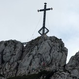
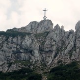
Kampenwand
Kampenwand