– Lat/Long: 69.47° N 19.92° E
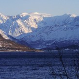
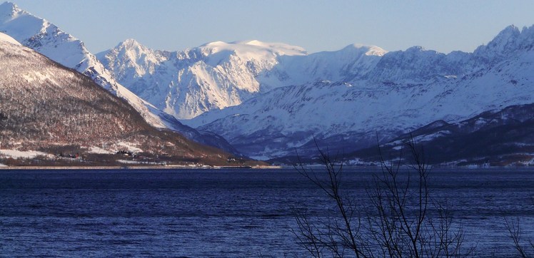
 Jiehkkevarri
Weather Forecast, NorwayIssued: 1 pm Tue 14 Jul Local TimeUpdates in: hr min sUpdate imminent
Issued: 1 pm Tue 14 Jul Local Time
Updates in:
Update imminent hr min s

Issued: 1 pm Tue 14 Jul Local Time
Updates in:
Update imminent hr min s
Days 1–4 Weather SummaryA light fall of snow, heaviest on Tue night. Turning milder with light rain (total 4mm) on Wed night. Freeze-thaw conditions (max 5°C on Wed night, min -1°C on Tue night). Winds increasing (moderate winds from the W on Wed afternoon, near gales from the WSW by Thu afternoon). | Days 5–7 Weather SummaryA light covering of new snow mostly falling on Fri afternoon. Temperatures will be below freezing (max -2°C on Fri afternoon, min -6°C on Sun night). Wind will be generally light. | ||||||||||||||||
Tue 14 | Wednesday 15 | Thursday 16 | Friday 17 | Saturday 18 | Sunday 19 | ||||||||||||
PM | night | AM | PM | night | AM | PM | night | AM | PM | night | AM | PM | night | AM | PM | night | |
light snow | mod. snow | light snow | cloudy | rain shwrs | some clouds | some clouds | light snow | light snow | light snow | snow shwrs | cloudy | some clouds | some clouds | snow shwrs | cloudy | light snow | |
km/h | |||||||||||||||||
 |  |  |  |  |  | ||||||||||||
2 | 8 | 1 | — | — | — | — | 2 | 1 | 2 | 1 | — | — | — | 2 | — | 1 | |
mm | — | — | — | — | 4 | — | — | 0.2 | — | — | — | — | — | — | — | — | — |
max °C | 1 | 1 | 1 | 2 | 5 | 5 | 5 | 3 | -1 | -2 | -2 | -3 | -3 | -3 | -4 | -4 | -5 |
min °C | 0 | -1 | 1 | 2 | 2 | 5 | 4 | 0 | -1 | -2 | -3 | -4 | -4 | -4 | -4 | -4 | -6 |
chill °C | -6 | -7 | -4 | -3 | -3 | -1 | -3 | -7 | -8 | -8 | -8 | -9 | -9 | -10 | -10 | -10 | -13 |
Freezing level m | 1850 | 1950 | 2000 | 2250 | 2800 | 3150 | 2750 | 2200 | 1550 | 1500 | 1400 | 1200 | 1300 | 1150 | 1100 | 1150 | 1000 |
Cloud base (m) | 450 | 450 | 450 | 450 | 450 | 1700 | 2050 | 450 | 450 | 450 | 650 | 700 | 800 | 750 | 450 | 650 | 600 |
— | — | 12:00 | — | — | 12:00 | — | — | 12:00 | — | — | 12:00 | — | — | 12:00 | — | — | |
12:00 | — | 12:00 | — | — | 12:00 | — | — | 12:00 | — | — | 12:00 | — | — | 12:00 | — | — | |
Loading...
Jiehkkevarri Weather (Days 0-3):
The weather forecast for Jiehkkevarri is: A light fall of snow, heaviest on Tue night. Turning milder with light rain (total 4mm) on Wed night. Freeze-thaw conditions (max 5°C on Wed night, min -1°C on Tue night). Winds increasing (moderate winds from the W on Wed afternoon, near gales from the WSW by Thu afternoon).
Jiehkkevarri Weather (Days 3-6):
A light covering of new snow mostly falling on Fri afternoon. Temperatures will be below freezing (max -2°C on Fri afternoon, min -6°C on Sun night). Wind will be generally light.
This table gives the weather forecast for Jiehkkevarri at the specific elevation of 1845 m. Our advanced weather models allow us to provide distinct weather forecasts for several elevations of Jiehkkevarri. To see the weather forecasts for the other elevations, use the tab navigation above the table. For a wider overview of the weather, consult the Weather Map of Norway.
| Weather Station | Temp. | Weather | Wind | Gusts | Cloud / Visibility |
|---|---|---|---|---|---|
Lyngen Gjerdvassbu | |||||
THPK Fjellheisen | |||||
Tromso -Holt | |||||
Troms / angnes Airport | |||||
THPK Finnvikdalen | |||||
THPK Ersfjord | |||||
THPK Aglapsvika |
* NOTE: not all weather observatories update at the same frequency which is the reason why some locations may show data from stations that are further away than known closer ones.