
– Lat/Long: 9.20° N 124.67° E
 Hibok-hibok
Weather Forecast, PhilippinesIssued: 7 pm Mon 03 Aug Local TimeUpdates in: hr min sUpdate imminent
Issued: 7 pm Mon 03 Aug Local Time
Updates in:
Update imminent hr min s

Issued: 7 pm Mon 03 Aug Local Time
Updates in:
Update imminent hr min s
Days 1–4 Weather SummaryModerate rain (total 11mm), heaviest on Wed night. Warm (max 21°C on Tue morning, min 19°C on Wed night). Winds increasing (moderate winds from the SW on Tue night, near gales from the WSW by Thu morning). | Days 5–7 Weather SummaryModerate rain (total 10mm), heaviest on Thu night. Warm (max 21°C on Sat morning, min 19°C on Thu night). Mainly near gales. | |||||||||||||||
Tuesday 4 | Wednesday 5 | Thursday 6 | Friday 7 | Saturday 8 | ||||||||||||
night | AM | PM | night | AM | PM | night | AM | PM | night | AM | PM | night | AM | PM | night | |
risk tstorm | some clouds | clear | risk tstorm | clear | risk tstorm | risk tstorm | risk tstorm | risk tstorm | risk tstorm | some clouds | risk tstorm | risk tstorm | clear | rain shwrs | risk tstorm | |
Cloud base (m) | 5450 | 300 | 250 | 9700 | 450 | 5300 | 250 | 250 | ||||||||
km/h | ||||||||||||||||
 |  |  |  |  |  | |||||||||||
— | — | — | — | — | — | — | — | — | — | — | — | — | — | — | — | |
mm | 2 | — | — | 1.6 | — | 1.4 | 4 | 1.1 | 0.5 | 1.4 | — | 0.9 | 3 | — | 0.5 | 3 |
max °C | 20 | 21 | 21 | 21 | 20 | 20 | 20 | 20 | 20 | 20 | 20 | 20 | 20 | 21 | 21 | 21 |
min °C | 20 | 20 | 21 | 20 | 20 | 20 | 19 | 19 | 20 | 19 | 20 | 20 | 20 | 20 | 21 | 20 |
chill °C | 20 | 20 | 21 | 20 | 19 | 19 | 18 | 18 | 19 | 18 | 19 | 19 | 19 | 19 | 20 | 19 |
Freezing level m | 5050 | 5150 | 5150 | 5150 | 5250 | 5150 | 5100 | 5100 | 5150 | 5100 | 5200 | 5250 | 5200 | 5350 | 5300 | 5200 |
— | 5:31 | — | — | 5:31 | — | — | 5:31 | — | — | 5:31 | — | — | 5:31 | — | — | |
— | — | 6:01 | — | — | 6:01 | — | — | 6:00 | — | — | 6:00 | — | — | 6:00 | — | |
Loading...
Hibok-hibok Weather (Days 0-3):
The weather forecast for Hibok-hibok is: Moderate rain (total 11mm), heaviest on Wed night. Warm (max 21°C on Tue morning, min 19°C on Wed night). Winds increasing (moderate winds from the SW on Tue night, near gales from the WSW by Thu morning).
Hibok-hibok Weather (Days 3-6):
Moderate rain (total 10mm), heaviest on Thu night. Warm (max 21°C on Sat morning, min 19°C on Thu night). Mainly near gales.
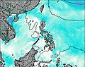
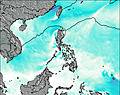
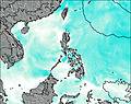
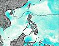
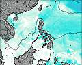
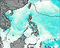
This table gives the weather forecast for Hibok-hibok at the specific elevation of 1332 m. Our advanced weather models allow us to provide distinct weather forecasts for several elevations of Hibok-hibok. To see the weather forecasts for the other elevations, use the tab navigation above the table. For a wider overview of the weather, consult the Weather Map of Philippines.
| Weather Station | Temp. | Weather | Wind | Gusts | Cloud / Visibility |
|---|---|---|---|---|---|
Butuan | |||||
Malaybalay | |||||
* NOTE: not all weather observatories update at the same frequency which is the reason why some locations may show data from stations that are further away than known closer ones.