
– Lat/Long: 47.05° N 11.28° E
 Habicht
Weather Forecast, AustriaIssued: 1 pm Fri 03 Jul Local TimeUpdates in: hr min sUpdate imminent
Issued: 1 pm Fri 03 Jul Local Time
Updates in:
Update imminent hr min s

Issued: 1 pm Fri 03 Jul Local Time
Updates in:
Update imminent hr min s
Days 1–4 Weather SummaryLight rain (total 7mm), mostly falling on Sun night. Very mild (max 11°C on Sat afternoon, min 5°C on Sun night). Wind will be generally light. | Days 5–7 Weather SummaryLight rain (total 3mm), mostly falling on Mon afternoon. Very mild (max 12°C on Tue afternoon, min 7°C on Mon night). Wind will be generally light. | ||||||||||||||||
Fri 3 | Saturday 4 | Sunday 5 | Monday 6 | Tuesday 7 | Wednesday 8 | ||||||||||||
PM | night | AM | PM | night | AM | PM | night | AM | PM | night | AM | PM | night | AM | PM | night | |
rain shwrs | rain shwrs | clear | clear | clear | clear | rain shwrs | rain shwrs | rain shwrs | rain shwrs | rain shwrs | clear | some clouds | some clouds | some clouds | rain shwrs | rain shwrs | |
km/h | |||||||||||||||||
 |  |  |  |  |  | ||||||||||||
— | — | — | — | — | — | — | — | — | — | — | — | — | — | — | — | — | |
mm | 1.4 | 0.2 | — | — | — | — | 0.1 | 4 | 0.5 | 1.5 | 0.6 | — | — | — | — | 0.1 | 1 |
max °C | 8 | 7 | 7 | 11 | 9 | 8 | 10 | 7 | 7 | 9 | 8 | 10 | 12 | 10 | 9 | 12 | 11 |
min °C | 8 | 6 | 6 | 10 | 6 | 7 | 9 | 5 | 6 | 8 | 7 | 8 | 11 | 7 | 7 | 11 | 8 |
chill °C | 6 | 4 | 4 | 8 | 4 | 5 | 7 | 3 | 4 | 6 | 5 | 7 | 8 | 4 | 4 | 10 | 6 |
Freezing level m | 3700 | 3750 | 3400 | 3850 | 3600 | 3550 | 3700 | 3300 | 3450 | 3750 | 3600 | 3800 | 3950 | 3750 | 3800 | 4200 | 4000 |
Cloud base (m) | 3050 | 2550 | 3150 | 3500 | 2300 | 3000 | 5200 | 5600 | 4350 | 3700 | 3450 | 3550 | 3450 | ||||
— | — | 5:24 | — | — | 5:24 | — | — | 5:26 | — | — | 5:26 | — | — | 5:28 | — | — | |
— | 9:13 | — | — | 9:12 | — | — | 9:12 | — | — | 9:12 | — | — | 9:10 | — | — | 9:10 | |
Loading...
Habicht Weather (Days 0-3):
The weather forecast for Habicht is: Light rain (total 7mm), mostly falling on Sun night. Very mild (max 11°C on Sat afternoon, min 5°C on Sun night). Wind will be generally light.
Habicht Weather (Days 3-6):
Light rain (total 3mm), mostly falling on Mon afternoon. Very mild (max 12°C on Tue afternoon, min 7°C on Mon night). Wind will be generally light.
This table gives the weather forecast for Habicht at the specific elevation of 2500 m. Our advanced weather models allow us to provide distinct weather forecasts for several elevations of Habicht. To see the weather forecasts for the other elevations, use the tab navigation above the table. For a wider overview of the weather, consult the Weather Map of Austria.
Habicht Photos
View all
Stubai Alps photos (22) |
Alps photos (1484) |
photos from mountains in Austria (215) |
all photos
 Upload new photo
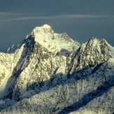
 See 9 more Habicht photos
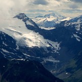
Habicht (goshawk) south face
Zuckerhütl
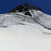
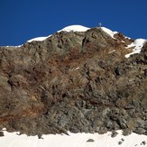
Habicht
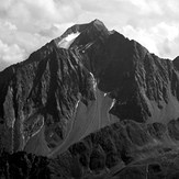
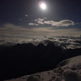
Habicht
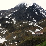
Habicht
Habicht
Habicht