– Lat/Long: 45.87° N 6.98° E
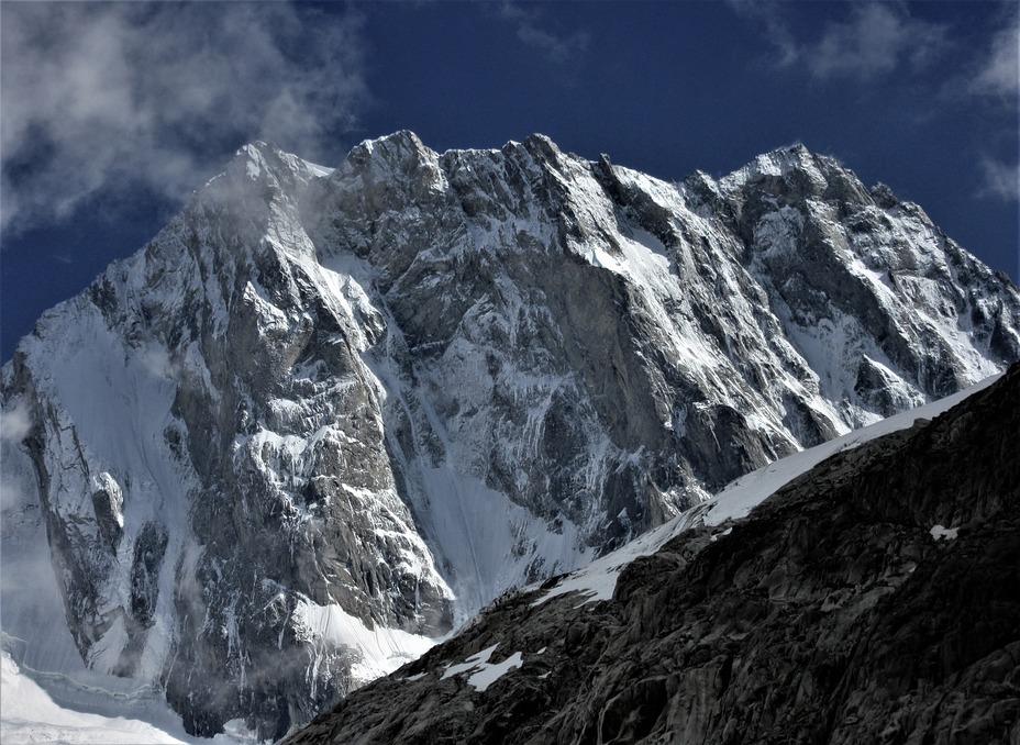
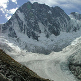
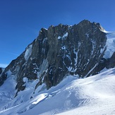
 Grandes Jorasses
Weather Forecast, FranceIssued: 1 pm Mon 03 Aug Local TimeUpdates in: hr min sUpdate imminent
Issued: 1 pm Mon 03 Aug Local Time
Updates in:
Update imminent hr min s

Issued: 1 pm Mon 03 Aug Local Time
Updates in:
Update imminent hr min s
Days 1–4 Weather SummaryMild with light rain (total 5mm) on Mon night Becoming colder with a light covering of snow, mostly falling on Tue afternoon. Temperatures will be slightly above freezing (max 3°C on Mon afternoon, min 1°C on Tue night). Wind will be generally light. | Days 5–7 Weather SummaryA dusting of new snow. Freeze-thaw conditions (max 2°C on Sat afternoon, min -1°C on Fri morning). Wind will be generally light. | ||||||||||||||||
Mon 3 | Tuesday 4 | Wednesday 5 | Thursday 6 | Friday 7 | Saturday 8 | ||||||||||||
PM | night | AM | PM | night | AM | PM | night | AM | PM | night | AM | PM | night | AM | PM | night | |
risk tstorm | snow shwrs | clear | snow shwrs | snow shwrs | clear | snow shwrs | snow shwrs | clear | snow shwrs | snow shwrs | clear | clear | clear | clear | clear | clear | |
Cloud base (m) | 3000 | 9450 | 6900 | 3200 | 9150 | 3150 | 3100 | 4300 | |||||||||
km/h | |||||||||||||||||
 |  |  |  |  |  | ||||||||||||
— | 1 | — | 2 | 2 | — | 2 | 1 | — | 2 | 2 | — | — | — | — | — | — | |
mm | 1.4 | 3 | — | 1.1 | — | — | — | — | — | — | — | — | — | — | — | — | — |
max °C | 3 | 2 | 2 | 2 | 2 | 1 | 2 | 2 | 1 | 1 | 0 | 0 | 0 | 1 | 0 | 2 | 2 |
min °C | 2 | 2 | 2 | 2 | 1 | 1 | 1 | 1 | 1 | 0 | 0 | -1 | 0 | 0 | 0 | 1 | 1 |
chill °C | -1 | -2 | -2 | -2 | -1 | 1 | -2 | -2 | -2 | -4 | -4 | -5 | -4 | -4 | -4 | -4 | -3 |
Freezing level m | 4500 | 4450 | 4450 | 4500 | 4450 | 4300 | 4450 | 4450 | 4300 | 4250 | 4200 | 4100 | 4250 | 4300 | 4250 | 4450 | 4450 |
— | — | 6:16 | — | — | 6:18 | — | — | 6:20 | — | — | 6:20 | — | — | 6:22 | — | — | |
— | 8:59 | — | — | 8:58 | — | — | 8:55 | — | — | 8:54 | — | — | 8:52 | — | — | 8:52 | |
Loading...
Grandes Jorasses Weather (Days 0-3):
The weather forecast for Grandes Jorasses is: Mild with light rain (total 5mm) on Mon night Becoming colder with a light covering of snow, mostly falling on Tue afternoon. Temperatures will be slightly above freezing (max 3°C on Mon afternoon, min 1°C on Tue night). Wind will be generally light.
Grandes Jorasses Weather (Days 3-6):
A dusting of new snow. Freeze-thaw conditions (max 2°C on Sat afternoon, min -1°C on Fri morning). Wind will be generally light.
This table gives the weather forecast for Grandes Jorasses at the specific elevation of 4208 m. Our advanced weather models allow us to provide distinct weather forecasts for several elevations of Grandes Jorasses. To see the weather forecasts for the other elevations, use the tab navigation above the table. For a wider overview of the weather, consult the Weather Map of France.
| Weather Station | Temp. | Weather | Wind | Gusts | Cloud / Visibility |
|---|---|---|---|---|---|
lightning 5km ESE of Chamonix-Mont-Blanc | |||||
lightning 5km WSW of Courmayeur | |||||
lightning 8km SE of Evionnaz | |||||
Col DU Grand ST -Bernard | |||||
lightning 6km S of Orsieres | |||||
Som la Proz | |||||
lightning 10km S of Morgex | |||||
lightning 4km WSW of Martigny-Combe | |||||
Col du Joly |
* NOTE: not all weather observatories update at the same frequency which is the reason why some locations may show data from stations that are further away than known closer ones.
Grandes Jorasses Photos
View all
Savoy Alps photos (141) |
Alps photos (1485) |
photos from mountains in France (302) |
all photos
 Upload new photo
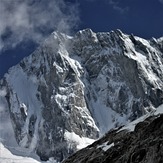
Grandes Jorasses
Star dust memory
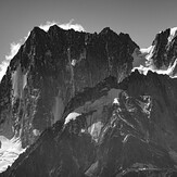
Mer de Glace
Grandes Jorasses
Jorasses North Face