– Lat/Long: 49.16° N 20.13° E
 Gerlach
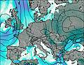
Weather Forecast, SlovakiaIssued: 1 pm Mon 03 Aug Local TimeUpdates in: hr min sUpdate imminent
Issued: 1 pm Mon 03 Aug Local Time
Updates in:
Update imminent hr min s

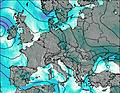
Issued: 1 pm Mon 03 Aug Local Time
Updates in:
Update imminent hr min s
Days 1–4 Weather SummaryMostly dry. Very mild (max 15°C on Wed afternoon, min 12°C on Mon afternoon). Wind will be generally light. | Days 5–7 Weather SummaryHeavy rain (total 26mm), heaviest during Fri night. Very mild (max 16°C on Thu afternoon, min 6°C on Fri night). Wind will be generally light. | ||||||||||||||||
Mon 3 | Tuesday 4 | Wednesday 5 | Thursday 6 | Friday 7 | Saturday 8 | ||||||||||||
PM | night | AM | PM | night | AM | PM | night | AM | PM | night | AM | PM | night | AM | PM | night | |
light rain | some clouds | some clouds | some clouds | clear | clear | clear | clear | clear | some clouds | rain shwrs | some clouds | risk tstorm | rain shwrs | some clouds | clear | clear | |
Cloud base (m) | 2750 | 3450 | 4300 | 4500 | 4500 | 4850 | 4450 | 4500 | 850 | 850 | 2250 | 2250 | |||||
km/h | |||||||||||||||||
 |  |  |  |  |  | ||||||||||||
— | — | — | — | — | — | — | — | — | — | — | — | — | — | — | — | — | |
mm | 0.3 | — | — | — | — | — | — | — | — | — | 0.7 | — | 7 | 18 | — | — | — |
max °C | 12 | 13 | 13 | 14 | 14 | 14 | 15 | 15 | 15 | 16 | 16 | 12 | 11 | 9 | 6 | 7 | 7 |
min °C | 12 | 12 | 13 | 13 | 14 | 14 | 15 | 15 | 15 | 15 | 12 | 11 | 9 | 6 | 6 | 7 | 6 |
chill °C | 10 | 10 | 12 | 12 | 13 | 13 | 14 | 15 | 14 | 14 | 10 | 10 | 9 | 3 | 4 | 4 | 2 |
Freezing level m | 4300 | 4400 | 4400 | 4500 | 4600 | 4500 | 4650 | 4600 | 4550 | 4650 | 4550 | 4450 | 4250 | 4100 | 3750 | 3850 | 3900 |
— | — | 5:13 | — | — | 5:16 | — | — | 5:16 | — | — | 5:18 | — | — | 5:20 | — | — | |
— | 8:15 | — | — | 8:15 | — | — | 8:13 | — | — | 8:12 | — | — | 8:09 | — | — | 8:07 | |
Loading...
Gerlach Weather (Days 0-3):
The weather forecast for Gerlach is: Mostly dry. Very mild (max 15°C on Wed afternoon, min 12°C on Mon afternoon). Wind will be generally light.
Gerlach Weather (Days 3-6):
Heavy rain (total 26mm), heaviest during Fri night. Very mild (max 16°C on Thu afternoon, min 6°C on Fri night). Wind will be generally light.
This table gives the weather forecast for Gerlach at the specific elevation of 2655 m. Our advanced weather models allow us to provide distinct weather forecasts for several elevations of Gerlach. To see the weather forecasts for the other elevations, use the tab navigation above the table. For a wider overview of the weather, consult the Weather Map of Slovakia.
| Weather Station | Temp. | Weather | Wind | Gusts | Cloud / Visibility |
|---|---|---|---|---|---|
thunderstorm affecting Vysoke Tatry | |||||
thunderstorm affecting Nova Lesna | |||||
thunderstorm affecting Svit | |||||
lightning 4km NE of Strba | |||||
lightning 9km S of Lubica | |||||
lightning 9km ESE of Poprad | |||||
thunderstorm affecting Levoca |
* NOTE: not all weather observatories update at the same frequency which is the reason why some locations may show data from stations that are further away than known closer ones.
Gerlach Photos
View all
Tatras photos (182) |
Carpathian Mountains photos (366) |
photos from mountains in Slovakia (78) |
all photos
 Upload new photo
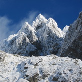

 See 21 more Gerlach photos
Gerlach
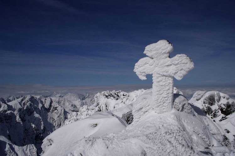
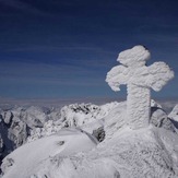
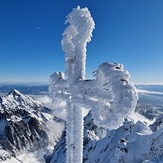
Winter shot of summit
Gerlach
Gerlach
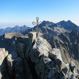
Gerlach summit
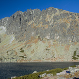
Gerlach i Batyżowiecki Staw
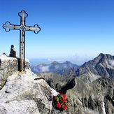
Gerlachovsky Stit