
– Lat/Long: 21.25° S 67.75° W
 Cerro San Agustin
Weather Forecast, BoliviaIssued: 1 pm Tue 21 Jul Local TimeUpdates in: hr min sUpdate imminent
Issued: 1 pm Tue 21 Jul Local Time
Updates in:
Update imminent hr min s

Issued: 1 pm Tue 21 Jul Local Time
Updates in:
Update imminent hr min s
Days 1–4 Weather SummaryMostly dry. Temperatures will be below freezing (max 0°C on Wed afternoon, min -6°C on Tue night). Winds decreasing (stormy winds from the WNW on Tue afternoon, moderate winds from the SW by Fri morning). | Days 5–7 Weather SummaryMostly dry. Freeze-thaw conditions (max 4°C on Sat afternoon, min -3°C on Sun night). Mainly fresh winds. | ||||||||||||||||
Tue 21 | Wednesday 22 | Thursday 23 | Friday 24 | Saturday 25 | Sunday 26 | ||||||||||||
PM | night | AM | PM | night | AM | PM | night | AM | PM | night | AM | PM | night | AM | PM | night | |
clear | clear | clear | clear | clear | clear | clear | clear | clear | clear | clear | clear | clear | clear | clear | clear | clear | |
Cloud base (m) | 6450 | ||||||||||||||||
km/h | |||||||||||||||||
 |  |  |  |  |  | ||||||||||||
— | — | — | — | — | — | — | — | — | — | — | — | — | — | — | — | — | |
mm | — | — | — | — | — | — | — | — | — | — | — | — | — | — | — | — | — |
max °C | -2 | -5 | -3 | 0 | -3 | -1 | 0 | -2 | 0 | 3 | 1 | 1 | 4 | 1 | 2 | 4 | 1 |
min °C | -3 | -6 | -6 | -1 | -5 | -5 | 0 | -4 | -3 | 3 | -1 | -1 | 4 | -1 | -1 | 4 | -3 |
chill °C | -14 | -17 | -16 | -10 | -15 | -15 | -8 | -13 | -11 | -3 | -6 | -6 | -1 | -6 | -6 | -1 | -9 |
Freezing level m | 4500 | 3900 | 4600 | 4900 | 4150 | 4800 | 5000 | 4450 | 5050 | 5350 | 4850 | 5200 | 5450 | 4800 | 5250 | 5400 | 4650 |
— | — | 7:05 | — | — | 7:05 | — | — | 7:05 | — | — | 7:05 | — | — | 7:05 | — | — | |
6:07 | — | — | 6:07 | — | — | 6:07 | — | — | 6:08 | — | — | 6:08 | — | — | 6:09 | — | |
Loading...
Cerro San Agustin Weather (Days 0-3):
The weather forecast for Cerro San Agustin is: Mostly dry. Temperatures will be below freezing (max 0°C on Wed afternoon, min -6°C on Tue night). Winds decreasing (stormy winds from the WNW on Tue afternoon, moderate winds from the SW by Fri morning).
Cerro San Agustin Weather (Days 3-6):
Mostly dry. Freeze-thaw conditions (max 4°C on Sat afternoon, min -3°C on Sun night). Mainly fresh winds.
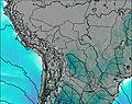
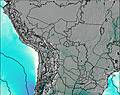
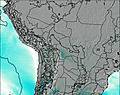
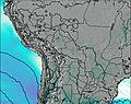
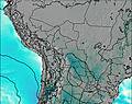
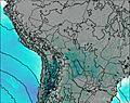
This table gives the weather forecast for Cerro San Agustin at the specific elevation of 4980 m. Our advanced weather models allow us to provide distinct weather forecasts for several elevations of Cerro San Agustin. To see the weather forecasts for the other elevations, use the tab navigation above the table. For a wider overview of the weather, consult the Weather Map of Bolivia.
| Weather Station | Temp. | Weather | Wind | Gusts | Cloud / Visibility |
|---|---|---|---|---|---|
Toconao | |||||
Tarij / apt Oriel Lea Plaza Airport | |||||
Alcantarí Airport- Yamparaez | |||||
Putre | |||||
Defensa Civil- Arica |
* NOTE: not all weather observatories update at the same frequency which is the reason why some locations may show data from stations that are further away than known closer ones.