– Lat/Long: 53.10° N 4.01° W
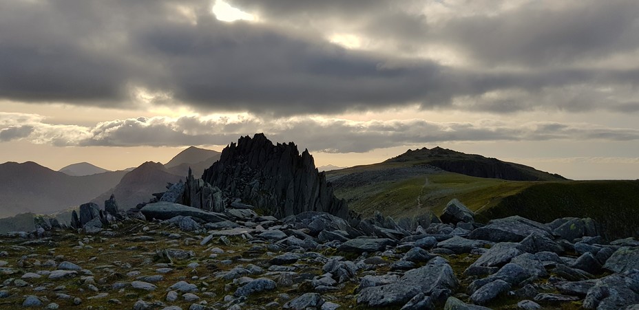
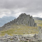
 Castell y Gwynt
Weather Forecast, United KingdomIssued: 12 pm Fri 03 Jul Local TimeUpdates in: hr min sUpdate imminent
Issued: 12 pm Fri 03 Jul Local Time
Updates in:
Update imminent hr min s

Issued: 12 pm Fri 03 Jul Local Time
Updates in:
Update imminent hr min s
Days 1–3 Weather SummarySome drizzle, heaviest during Sat afternoon. Warm (max 20°C on Sat afternoon, min 15°C on Fri night). Mainly fresh winds. | Days 4–6 Weather SummaryMostly dry. Warm (max 21°C on Tue afternoon, min 15°C on Mon night). Wind will be generally light. | |||||||||||||||||
Friday 3 | Saturday 4 | Sunday 5 | Monday 6 | Tuesday 7 | Wednesday 8 | |||||||||||||
AM | PM | night | AM | PM | night | AM | PM | night | AM | PM | night | AM | PM | night | AM | PM | night | |
some clouds | clear | light rain | rain shwrs | rain shwrs | light rain | rain shwrs | some clouds | some clouds | some clouds | some clouds | some clouds | cloudy | some clouds | clear | clear | clear | clear | |
km/h | ||||||||||||||||||
 |  |  |  |  |  | |||||||||||||
— | — | — | — | — | — | — | — | — | — | — | — | — | — | — | — | — | — | |
mm | — | — | 0.1 | 0.1 | 0.6 | 0.5 | 0.2 | — | — | — | — | — | — | — | — | — | — | — |
max °C | 17 | 17 | 16 | 19 | 20 | 17 | 18 | 19 | 15 | 19 | 20 | 16 | 17 | 21 | 18 | 19 | 19 | 17 |
min °C | 16 | 16 | 15 | 17 | 19 | 15 | 16 | 18 | 15 | 18 | 19 | 15 | 16 | 19 | 17 | 19 | 18 | 16 |
chill °C | 15 | 15 | 14 | 16 | 19 | 14 | 15 | 17 | 14 | 18 | 19 | 14 | 16 | 19 | 17 | 19 | 18 | 16 |
Freezing level m | 3100 | 3500 | 3800 | 3700 | 3750 | 3450 | 3550 | 3650 | 3650 | 3550 | 3700 | 3800 | 4150 | 4300 | 4250 | 4150 | 4100 | 4050 |
Cloud base (m) | 400 | 3200 | 350 | 550 | 700 | 550 | 300 | 500 | 300 | 300 | 250 | 450 | 350 | |||||
4:54 | — | — | 4:54 | — | — | 4:56 | — | — | 4:56 | — | — | 4:58 | — | — | 4:58 | — | — | |
— | 9:44 | — | — | 9:44 | — | — | 9:43 | — | — | 9:43 | — | — | 9:42 | — | — | 9:42 | — | |
Loading...
Castell y Gwynt Weather (Days 0-3):
The weather forecast for Castell y Gwynt is: Some drizzle, heaviest during Sat afternoon. Warm (max 20°C on Sat afternoon, min 15°C on Fri night). Mainly fresh winds.
Castell y Gwynt Weather (Days 3-6):
Mostly dry. Warm (max 21°C on Tue afternoon, min 15°C on Mon night). Wind will be generally light.
This table gives the weather forecast for Castell y Gwynt at the specific elevation of 0 m. Our advanced weather models allow us to provide distinct weather forecasts for several elevations of Castell y Gwynt. To see the weather forecasts for the other elevations, use the tab navigation above the table. For a wider overview of the weather, consult the Weather Map of United Kingdom.
| Weather Station | Temp. | Weather | Wind | Gusts | Cloud / Visibility |
|---|---|---|---|---|---|
Caernarfon Airport | |||||
Valley RAF Airport | |||||
BARCIAL | |||||
HORNACHOS IM2 | |||||
SHIP325 |
* NOTE: not all weather observatories update at the same frequency which is the reason why some locations may show data from stations that are further away than known closer ones.
Castell y Gwynt Photos
View all
Snowdonia photos (205) |
Cambrian Mountains photos (383) |
photos from mountains in United Kingdom (2122) |
all photos
 Upload new photo
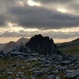
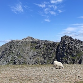
Castell y Gwynt shows it's true character.
Castell y Gwynt
Castell y Gwynt