– Lat/Long: 81.91° N 75.02° W
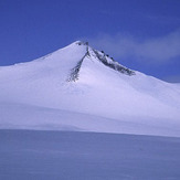
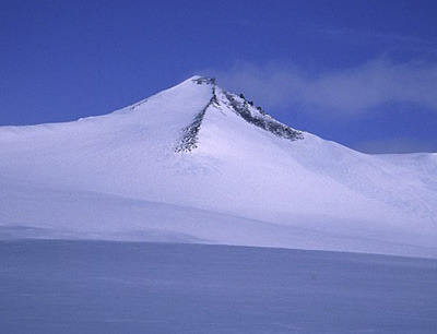
 Barbeau Peak
Weather Forecast, CanadaIssued: 8 am Mon 03 Aug Local TimeUpdates in: hr min sUpdate imminent
Issued: 8 am Mon 03 Aug Local Time
Updates in:
Update imminent hr min s

Issued: 8 am Mon 03 Aug Local Time
Updates in:
Update imminent hr min s
Days 1–3 Weather SummaryA light covering of new snow mostly falling on Mon morning. Temperatures will be below freezing (max 0°C on Wed night, min -8°C on Tue night). Winds increasing (light winds from the NE on Mon night, gales from the W by Tue night). | Days 4–6 Weather SummaryA dusting of new snow. Temperatures will be below freezing (max 0°C on Thu afternoon, min -8°C on Sat night). Winds increasing (moderate winds from the W on Thu night, stormy winds from the W by Sat night). | |||||||||||||||||
Monday 3 | Tuesday 4 | Wednesday 5 | Thursday 6 | Friday 7 | Saturday 8 | |||||||||||||
AM | PM | night | AM | PM | night | AM | PM | night | AM | PM | night | AM | PM | night | AM | PM | night | |
light snow | light snow | snow shwrs | some clouds | some clouds | light snow | some clouds | some clouds | some clouds | cloudy | clear | clear | clear | clear | some clouds | clear | snow shwrs | snow shwrs | |
Cloud base (m) | 1650 | 1550 | 1550 | 1600 | 1600 | 1550 | 1600 | 1600 | 2200 | 2350 | 2400 | 5400 | 1600 | 1550 | 1550 | |||
km/h | ||||||||||||||||||
 |  |  |  |  |  | |||||||||||||
4 | 2 | 1 | — | — | 2 | — | — | — | — | — | — | — | — | — | — | 1 | 2 | |
mm | — | — | — | — | — | — | — | — | — | — | — | — | — | — | — | — | — | — |
max °C | -4 | -6 | -5 | -5 | -5 | -4 | -4 | -2 | 0 | -1 | 0 | -1 | -2 | -2 | -2 | -5 | -6 | -6 |
min °C | -5 | -6 | -6 | -6 | -5 | -8 | -5 | -3 | -1 | -1 | 0 | -2 | -2 | -2 | -5 | -6 | -6 | -8 |
chill °C | -10 | -11 | -12 | -11 | -12 | -20 | -14 | -11 | -9 | -7 | -6 | -8 | -8 | -8 | -16 | -17 | -18 | -20 |
Freezing level m | 1700 | 1500 | 1300 | 1300 | 1300 | 1050 | 1150 | 1400 | 2350 | 2500 | 2650 | 2200 | 2000 | 2050 | 1400 | 1350 | 1350 | 1100 |
12:00 | — | — | 12:00 | — | — | 12:00 | — | — | 12:00 | — | — | 12:00 | — | — | 12:00 | — | — | |
12:00 | — | — | 12:00 | — | — | 12:00 | — | — | 12:00 | — | — | 12:00 | — | — | 12:00 | — | — | |
Loading...
Barbeau Peak Weather (Days 0-3):
The weather forecast for Barbeau Peak is: A light covering of new snow mostly falling on Mon morning. Temperatures will be below freezing (max 0°C on Wed night, min -8°C on Tue night). Winds increasing (light winds from the NE on Mon night, gales from the W by Tue night).
Barbeau Peak Weather (Days 3-6):
A dusting of new snow. Temperatures will be below freezing (max 0°C on Thu afternoon, min -8°C on Sat night). Winds increasing (moderate winds from the W on Thu night, stormy winds from the W by Sat night).
This table gives the weather forecast for Barbeau Peak at the specific elevation of 2616 m. Our advanced weather models allow us to provide distinct weather forecasts for several elevations of Barbeau Peak. To see the weather forecasts for the other elevations, use the tab navigation above the table. For a wider overview of the weather, consult the Weather Map of Nunavut.
| Weather Station | Temp. | Weather | Wind | Gusts | Cloud / Visibility |
|---|---|---|---|---|---|
Alert Airport | |||||
Eureka Airport | |||||
Svartevaeg- NU | |||||
Eureka Climate | |||||
Mittarfik Qaanaaq | |||||
Kap Morris Jesup | |||||
Thule Air Base Airport | |||||
Grise Fiord Climate- NU |
* NOTE: not all weather observatories update at the same frequency which is the reason why some locations may show data from stations that are further away than known closer ones.