– Lat/Long: 43.38° N 144.02° E
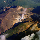
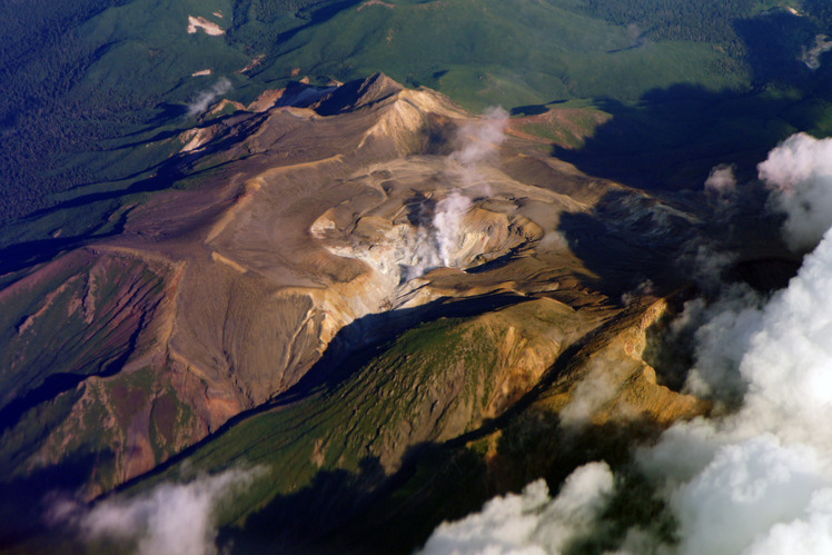
 Akan
Akan
Weather Forecast, JapanIssued: 2 pm Tue 28 Jul Local TimeUpdates in: hr min sUpdate imminent
Issued: 2 pm Tue 28 Jul Local Time
Updates in:
Update imminent hr min s

Issued: 2 pm Tue 28 Jul Local Time
Updates in:
Update imminent hr min s
Days 1–4 Weather SummarySome drizzle, heaviest during Wed afternoon. Very mild (max 19°C on Tue afternoon, min 14°C on Thu night). Wind will be generally light. | Days 5–7 Weather SummarySome drizzle, heaviest during Fri afternoon. Warm (max 20°C on Sat morning, min 14°C on Fri night). Wind will be generally light. | ||||||||||||||||
Tue 28 | Wednesday 29 | Thursday 30 | Friday 31 | Saturday 1 | Sunday 2 | ||||||||||||
PM | night | AM | PM | night | AM | PM | night | AM | PM | night | AM | PM | night | AM | PM | night | |
rain shwrs | some clouds | light rain | light rain | rain shwrs | some clouds | cloudy | cloudy | light rain | light rain | light rain | some clouds | some clouds | clear | some clouds | rain shwrs | some clouds | |
Cloud base (m) | 1750 | 750 | 1450 | 1450 | 1650 | 1800 | 2700 | 1600 | 400 | 400 | 700 | 1550 | 2300 | 2600 | 300 | ||
km/h | |||||||||||||||||
 |  |  |  |  |  | ||||||||||||
— | — | — | — | — | — | — | — | — | — | — | — | — | — | — | — | — | |
mm | 0.3 | — | 0.1 | 0.9 | 0.3 | — | — | — | 0.2 | 1.2 | 0.1 | — | — | — | — | 0.2 | — |
max °C | 19 | 16 | 18 | 18 | 16 | 19 | 19 | 15 | 16 | 15 | 15 | 20 | 19 | 16 | 20 | 20 | 18 |
min °C | 18 | 15 | 18 | 17 | 16 | 17 | 17 | 14 | 15 | 15 | 14 | 18 | 17 | 15 | 19 | 19 | 17 |
chill °C | 18 | 15 | 18 | 17 | 16 | 17 | 17 | 14 | 15 | 15 | 14 | 18 | 17 | 15 | 19 | 19 | 17 |
Freezing level m | 4350 | 4400 | 4250 | 4200 | 4200 | 4100 | 4150 | 4000 | 3950 | 3800 | 3750 | 4300 | 4400 | 4500 | 4650 | 4850 | 4900 |
— | — | 4:09 | — | — | 4:11 | — | — | 4:11 | — | — | 4:13 | — | — | 4:13 | — | — | |
6:51 | — | — | 6:50 | — | — | 6:49 | — | — | 6:46 | — | — | 6:45 | — | — | 6:45 | — | |
Loading...
Akan Weather (Days 0-3):
The weather forecast for Akan is: Some drizzle, heaviest during Wed afternoon. Very mild (max 19°C on Tue afternoon, min 14°C on Thu night). Wind will be generally light.
Akan Weather (Days 3-6):
Some drizzle, heaviest during Fri afternoon. Warm (max 20°C on Sat morning, min 14°C on Fri night). Wind will be generally light.
This table gives the weather forecast for Akan at the specific elevation of 500 m. Our advanced weather models allow us to provide distinct weather forecasts for several elevations of Akan. To see the weather forecasts for the other elevations, use the tab navigation above the table. For a wider overview of the weather, consult the Weather Map of Japan.
| Weather Station | Temp. | Weather | Wind | Gusts | Cloud / Visibility |
|---|---|---|---|---|---|
Kushiro Airport | |||||
Nakashibetsu Airport | |||||
Monbetsu Airport | |||||
Asahikawa Airport | |||||
Chitose Airport | |||||
Sapporo Airport | |||||
Wakkanai Airport | |||||
Hakodate Airport |
* NOTE: not all weather observatories update at the same frequency which is the reason why some locations may show data from stations that are further away than known closer ones.