– Lat/Long: 45.94° N 6.97° E
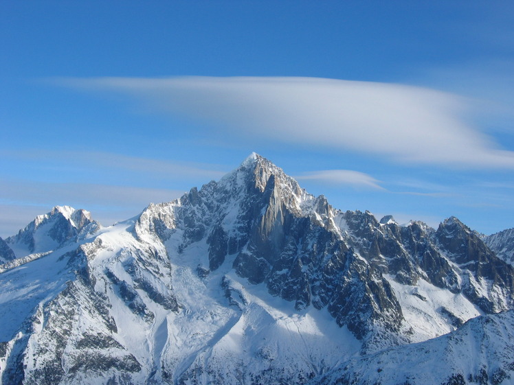
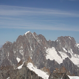
 Aiguille Verte
Weather Forecast, FranceIssued: 1 am Sun 26 Jul Local TimeUpdates in: hr min sUpdate imminent
Issued: 1 am Sun 26 Jul Local Time
Updates in:
Update imminent hr min s

Issued: 1 am Sun 26 Jul Local Time
Updates in:
Update imminent hr min s
Days 1–3 Weather SummaryA dusting of new snow. Freeze-thaw conditions (max 9°C on Mon night, min -1°C on Sun morning). Wind will be generally light. | Days 4–6 Weather SummaryLight rain (total 2mm), mostly falling on Fri night. Very mild (max 11°C on Fri afternoon, min 6°C on Wed morning). Wind will be generally light. | |||||||||||||||||
Sunday 26 | Monday 27 | Tuesday 28 | Wednesday 29 | Thursday 30 | Friday 31 | |||||||||||||
AM | PM | night | AM | PM | night | AM | PM | night | AM | PM | night | AM | PM | night | AM | PM | night | |
light snow | snow shwrs | clear | clear | some clouds | clear | clear | clear | rain shwrs | risk tstorm | clear | clear | clear | clear | clear | clear | some clouds | rain shwrs | |
Cloud base (m) | 2300 | 2350 | 2800 | 3250 | 4300 | 4700 | 6550 | 5200 | 4750 | |||||||||
km/h | ||||||||||||||||||
 |  |  |  |  |  | |||||||||||||
2 | 1 | — | — | — | — | — | — | — | — | — | — | — | — | — | — | — | — | |
mm | — | — | — | — | — | — | — | — | 0.4 | 0.2 | — | — | — | — | — | — | — | 2 |
max °C | -1 | 0 | 1 | 3 | 4 | 9 | 8 | 8 | 7 | 6 | 8 | 9 | 8 | 10 | 10 | 9 | 11 | 11 |
min °C | -1 | 0 | 0 | 3 | 3 | 5 | 7 | 7 | 6 | 6 | 7 | 8 | 8 | 9 | 9 | 9 | 10 | 9 |
chill °C | -4 | -4 | -4 | -1 | 0 | 4 | 6 | 6 | 4 | 4 | 5 | 6 | 6 | 8 | 8 | 8 | 8 | 6 |
Freezing level m | 3400 | 3500 | 3500 | 4050 | 4250 | 4750 | 4650 | 4700 | 4550 | 4400 | 4650 | 4700 | 4650 | 4800 | 4800 | 4700 | 4900 | 4800 |
6:07 | — | — | 6:07 | — | — | 6:09 | — | — | 6:09 | — | — | 6:11 | — | — | 6:11 | — | — | |
— | — | 9:08 | — | — | 9:07 | — | — | 9:07 | — | — | 9:06 | — | — | 9:04 | — | — | 9:02 | |
Loading...
Aiguille Verte Weather (Days 0-3):
The weather forecast for Aiguille Verte is: A dusting of new snow. Freeze-thaw conditions (max 9°C on Mon night, min -1°C on Sun morning). Wind will be generally light.
Aiguille Verte Weather (Days 3-6):
Light rain (total 2mm), mostly falling on Fri night. Very mild (max 11°C on Fri afternoon, min 6°C on Wed morning). Wind will be generally light.
This table gives the weather forecast for Aiguille Verte at the specific elevation of 3500 m. Our advanced weather models allow us to provide distinct weather forecasts for several elevations of Aiguille Verte. To see the weather forecasts for the other elevations, use the tab navigation above the table. For a wider overview of the weather, consult the Weather Map of France.
* NOTE: not all weather observatories update at the same frequency which is the reason why some locations may show data from stations that are further away than known closer ones.
Aiguille Verte Photos
View all
Savoy Alps photos (141) |
Alps photos (1485) |
photos from mountains in France (302) |
all photos
 Upload new photo
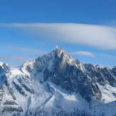
Aiguille Verte
Aiguille Verte