
– Lat/Long: 46.98° S 167.88° E
 Rakeahua Hut
Weather Forecast, New ZealandIssued: 11 am Tue 16 Jun Local TimeUpdates in: hr min sUpdate imminent
Issued: 11 am Tue 16 Jun Local Time
Updates in:
Update imminent hr min s

Issued: 11 am Tue 16 Jun Local Time
Updates in:
Update imminent hr min s
Days 1–3 Weather SummaryModerate rain (total 20mm), heaviest on Tue night. Very mild (max 11°C on Tue afternoon, min 7°C on Wed morning). Winds decreasing (strong winds from the WNW on Tue night, light winds from the NNE by Thu night). | Days 4–6 Weather SummaryHeavy rain (total 27mm), heaviest during Sat morning. Very mild (max 15°C on Fri afternoon, min 9°C on Sat night). Winds decreasing (strong winds from the NW on Fri night, light winds from the WSW by Sun night). | |||||||||||||||||
Tuesday 16 | Wednesday 17 | Thursday 18 | Friday 19 | Saturday 20 | Sunday 21 | |||||||||||||
AM | PM | night | AM | PM | night | AM | PM | night | AM | PM | night | AM | PM | night | AM | PM | night | |
light rain | light rain | rain shwrs | rain shwrs | rain shwrs | light rain | light rain | light rain | light rain | rain shwrs | light rain | mod. rain | heavy rain | rain shwrs | rain shwrs | light rain | rain shwrs | rain shwrs | |
km/h | ||||||||||||||||||
 |  |  |  |  |  | |||||||||||||
— | — | — | — | — | — | — | — | — | — | — | — | — | — | — | — | — | — | |
0.2 | 1 | 13 | 0.3 | 0.1 | 1.2 | 0.7 | 1.3 | 1.7 | 0.8 | 0.5 | 8 | 12 | 2 | 1 | 0.6 | 0.7 | 0.5 | |
max °C | 10 | 11 | 10 | 8 | 8 | 10 | 10 | 10 | 10 | 14 | 15 | 15 | 14 | 12 | 11 | 10 | 11 | 10 |
min °C | 8 | 10 | 8 | 7 | 8 | 9 | 10 | 10 | 8 | 12 | 15 | 14 | 11 | 12 | 9 | 10 | 10 | 9 |
5 | 6 | 5 | 4 | 5 | 6 | 7 | 7 | 6 | 10 | 13 | 12 | 9 | 10 | 6 | 7 | 7 | 7 | |
1450 | 1400 | 1200 | 850 | 950 | 1100 | 1150 | 1300 | 1400 | 2350 | 2450 | 2500 | 2500 | 1750 | 1550 | 1200 | 1400 | 1550 | |
Cloud base (m) | 700 | 150 | 250 | 300 | 400 | 300 | 200 | 150 | 200 | 350 | 400 | 150 | 650 | 200 | 350 | 200 | 200 | 450 |
8:33 | — | — | 8:33 | — | — | 8:33 | — | — | 8:33 | — | — | 8:33 | — | — | 8:33 | — | — | |
— | 5:04 | — | — | 5:04 | — | — | 5:05 | — | — | 5:05 | — | — | 5:05 | — | — | 5:05 | — | |
Loading...
Rakeahua Hut Weather (Days 0-3):
The weather forecast for Rakeahua Hut is: Moderate rain (total 20mm), heaviest on Tue night. Very mild (max 11°C on Tue afternoon, min 7°C on Wed morning). Winds decreasing (strong winds from the WNW on Tue night, light winds from the NNE by Thu night).
Rakeahua Hut Weather (Days 3-6):
Heavy rain (total 27mm), heaviest during Sat morning. Very mild (max 15°C on Fri afternoon, min 9°C on Sat night). Winds decreasing (strong winds from the NW on Fri night, light winds from the WSW by Sun night).
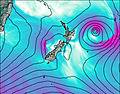
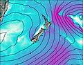
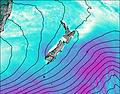
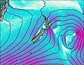
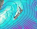
This table gives the weather forecast for Rakeahua Hut at the specific elevation of 16 m. Our advanced weather models allow us to provide distinct weather forecasts for several elevations of Rakeahua Hut. To see the weather forecasts for the other elevations, use the tab navigation above the table. For a wider overview of the weather, consult the Weather Map of New Zealand.
| Weather Station | Temp. | Weather | Wind | Gusts | Cloud / Visibility |
|---|---|---|---|---|---|
InvercargillAeroAws | |||||
PuysegurPointAws | |||||
Nugget Point Automatic Weather Station | |||||
SecretaryIslandAws | |||||
DunedinAeroAws | |||||
Dunedin Airport | |||||
Skyline Gondola | |||||
QueenstownAeroAws | |||||
Terrace SouthernClub |
* NOTE: not all weather observatories update at the same frequency which is the reason why some locations may show data from stations that are further away than known closer ones.