
– Lat/Long: 52.24° N 3.75° W
 Moel Prysgau
Weather Forecast, United KingdomIssued: 6 pm Sun 28 Jun Local TimeUpdates in: hr min sUpdate imminent
Issued: 6 pm Sun 28 Jun Local Time
Updates in:
Update imminent hr min s

Issued: 6 pm Sun 28 Jun Local Time
Updates in:
Update imminent hr min s
Days 1–4 Weather SummaryLight rain (total 2mm), mostly falling on Tue afternoon. Very mild (max 15°C on Sun afternoon, min 9°C on Sun night). Winds decreasing (fresh winds from the WSW on Sun afternoon, light winds from the SW by Mon night). | Days 5–7 Weather SummaryMostly dry. Very mild (max 17°C on Fri morning, min 10°C on Thu night). Winds decreasing (fresh winds from the NW on Thu morning, light winds from the WNW by Thu night). | ||||||||||||||||
Sun 28 | Monday 29 | Tuesday 30 | Wednesday 1 | Thursday 2 | Friday 3 | ||||||||||||
PM | night | AM | PM | night | AM | PM | night | AM | PM | night | AM | PM | night | AM | PM | night | |
rain shwrs | some clouds | some clouds | light rain | rain shwrs | light rain | rain shwrs | rain shwrs | rain shwrs | clear | rain shwrs | rain shwrs | clear | clear | some clouds | some clouds | some clouds | |
km/h | |||||||||||||||||
 |  |  |  |  |  | ||||||||||||
— | — | — | — | — | — | — | — | — | — | — | — | — | — | — | — | — | |
mm | 0.1 | — | — | 0.1 | 0.1 | 0.1 | 1.6 | 0.1 | 0.1 | — | 0.4 | 0.3 | — | — | — | — | — |
max °C | 15 | 11 | 15 | 15 | 12 | 14 | 15 | 13 | 15 | 16 | 14 | 14 | 14 | 11 | 17 | 16 | 13 |
min °C | 14 | 9 | 13 | 14 | 11 | 14 | 15 | 13 | 13 | 15 | 11 | 13 | 14 | 10 | 14 | 15 | 11 |
chill °C | 12 | 7 | 11 | 13 | 10 | 12 | 14 | 12 | 12 | 14 | 8 | 10 | 12 | 9 | 13 | 14 | 9 |
Freezing level m | 3150 | 3100 | 3000 | 2750 | 3000 | 2700 | 3000 | 3050 | 3500 | 3650 | 4050 | 3850 | 3400 | 3300 | 3600 | 3850 | 4000 |
Cloud base (m) | 1550 | 650 | 400 | 900 | 2900 | 1700 | 500 | 550 | 400 | 650 | 300 | 400 | 6100 | 9500 | 6550 | ||
— | — | 4:56 | — | — | 4:56 | — | — | 4:58 | — | — | 4:58 | — | — | 4:58 | — | — | |
9:39 | — | — | 9:38 | — | — | 9:38 | — | — | 9:38 | — | — | 9:37 | — | — | 9:37 | — | |
Loading...
Moel Prysgau Weather (Days 0-3):
The weather forecast for Moel Prysgau is: Light rain (total 2mm), mostly falling on Tue afternoon. Very mild (max 15°C on Sun afternoon, min 9°C on Sun night). Winds decreasing (fresh winds from the WSW on Sun afternoon, light winds from the SW by Mon night).
Moel Prysgau Weather (Days 3-6):
Mostly dry. Very mild (max 17°C on Fri morning, min 10°C on Thu night). Winds decreasing (fresh winds from the NW on Thu morning, light winds from the WNW by Thu night).
This table gives the weather forecast for Moel Prysgau at the specific elevation of 378 m. Our advanced weather models allow us to provide distinct weather forecasts for several elevations of Moel Prysgau. To see the weather forecasts for the other elevations, use the tab navigation above the table. For a wider overview of the weather, consult the Weather Map of United Kingdom.
| Weather Station | Temp. | Weather | Wind | Gusts | Cloud / Visibility |
|---|---|---|---|---|---|
Clatter | |||||
Long Mynd | |||||
Blorenge | |||||
Llethryd Barns | |||||
* NOTE: not all weather observatories update at the same frequency which is the reason why some locations may show data from stations that are further away than known closer ones.
Moel Prysgau Photos
View all
Radnor Hills photos (7) |
Cambrian Mountains photos (383) |
photos from mountains in United Kingdom (2122) |
all photos
 Upload new photo
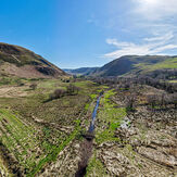
Berwyn Valley
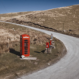
Wales’ most remote phonebox
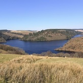
Afon Brefi