
– Lat/Long: 42.30° S 172.29° E
 Kōhanga Atawhai – Manson Nicholls Hut (Kohanga Atawhai - Manson Nicholls Hut)
Weather Forecast, New ZealandIssued: 11 am Sun 12 Jul Local TimeUpdates in: hr min sUpdate imminent
Issued: 11 am Sun 12 Jul Local Time
Updates in:
Update imminent hr min s

Issued: 11 am Sun 12 Jul Local Time
Updates in:
Update imminent hr min s
Days 1–3 Weather SummaryModerate rain (total 19mm), heaviest on Mon night. Mild temperatures (max 8°C on Tue afternoon, min 3°C on Sun morning). Wind will be generally light. | Days 4–6 Weather SummaryHeavy rain (total 21mm), heaviest during Wed night. Mild temperatures (max 9°C on Wed morning, min 4°C on Wed night). Wind will be generally light. | |||||||||||||||||
Sunday 12 | Monday 13 | Tuesday 14 | Wednesday 15 | Thursday 16 | Friday 17 | |||||||||||||
AM | PM | night | AM | PM | night | AM | PM | night | AM | PM | night | AM | PM | night | AM | PM | night | |
clear | cloudy | light rain | cloudy | light rain | mod. rain | light rain | light rain | mod. rain | light rain | light rain | rain shwrs | clear | some clouds | rain shwrs | some clouds | some clouds | light rain | |
km/h | ||||||||||||||||||
 |  |  |  |  |  | |||||||||||||
— | — | — | — | — | — | — | — | — | — | — | — | — | — | — | — | — | — | |
mm | — | — | 0.2 | — | 1.2 | 9 | 0.6 | 1.4 | 6 | 2 | 5 | 13 | — | — | 0.1 | — | — | 0.2 |
max °C | 6 | 7 | 4 | 6 | 6 | 6 | 7 | 8 | 8 | 9 | 8 | 7 | 6 | 7 | 6 | 8 | 8 | 6 |
min °C | 3 | 4 | 4 | 4 | 5 | 5 | 7 | 7 | 8 | 8 | 8 | 4 | 4 | 4 | 4 | 5 | 6 | 5 |
chill °C | 3 | 3 | 3 | 2 | 2 | 3 | 4 | 4 | 6 | 7 | 6 | 4 | 4 | 3 | 4 | 4 | 5 | 4 |
Freezing level m | 1250 | 1600 | 1500 | 1350 | 1450 | 1850 | 1750 | 1950 | 2000 | 1900 | 1850 | 1650 | 1350 | 1450 | 1750 | 1500 | 1950 | 1700 |
Cloud base (m) | 900 | 900 | 850 | 650 | 800 | 650 | 650 | 600 | 650 | 650 | 750 | 650 | 800 | 950 | 700 | 950 | 950 | 850 |
7:56 | — | — | 7:56 | — | — | 7:56 | — | — | 7:54 | — | — | 7:54 | — | — | 7:54 | — | — | |
— | 5:15 | — | — | 5:15 | — | — | 5:16 | — | — | 5:17 | — | — | 5:17 | — | — | 5:19 | — | |
Loading...
Kōhanga Atawhai – Manson Nicholls Hut Weather (Days 0-3):
The weather forecast for Kōhanga Atawhai – Manson Nicholls Hut is: Moderate rain (total 19mm), heaviest on Mon night. Mild temperatures (max 8°C on Tue afternoon, min 3°C on Sun morning). Wind will be generally light.
Kōhanga Atawhai – Manson Nicholls Hut Weather (Days 3-6):
Heavy rain (total 21mm), heaviest during Wed night. Mild temperatures (max 9°C on Wed morning, min 4°C on Wed night). Wind will be generally light.
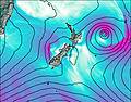
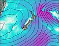
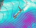
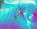
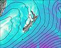
This table gives the weather forecast for Kōhanga Atawhai – Manson Nicholls Hut at the specific elevation of 577 m. Our advanced weather models allow us to provide distinct weather forecasts for several elevations of Kōhanga Atawhai – Manson Nicholls Hut. To see the weather forecasts for the other elevations, use the tab navigation above the table. For a wider overview of the weather, consult the Weather Map of New Zealand.
| Weather Station | Temp. | Weather | Wind | Gusts | Cloud / Visibility |
|---|---|---|---|---|---|
Lewis Pass | |||||
Maruia | |||||
Ahaura Rv at Gorge | |||||
Island Hills | |||||
Murchison | |||||
Pudding Hill | |||||
Nelson Creek | |||||
* NOTE: not all weather observatories update at the same frequency which is the reason why some locations may show data from stations that are further away than known closer ones.