
– Lat/Long: 53.12° N 4.05° W
 Y Garn (Glyderau)
Weather Forecast, United KingdomIssued: 12 am Mon 03 Aug Local TimeUpdates in: hr min sUpdate imminent
Issued: 12 am Mon 03 Aug Local Time
Updates in:
Update imminent hr min s

Issued: 12 am Mon 03 Aug Local Time
Updates in:
Update imminent hr min s
Days 1–4 Weather SummaryLight rain (total 7mm), mostly falling on Tue morning. Warm (max 25°C on Mon morning, min 15°C on Tue night). Winds increasing (calm on Mon night, strong winds from the WSW by Wed afternoon). | Days 5–7 Weather SummaryLight rain (total 3mm), mostly falling on Wed night. Very mild (max 19°C on Fri afternoon, min 13°C on Thu night). Mainly fresh winds. | ||||||||||||||||||
Monday 3 | Tuesday 4 | Wednesday 5 | Thursday 6 | Friday 7 | Saturday 8 | ||||||||||||||
night | AM | PM | night | AM | PM | night | AM | PM | night | AM | PM | night | AM | PM | night | AM | PM | night | |
some clouds | some clouds | light rain | light rain | light rain | rain shwrs | rain shwrs | rain shwrs | rain shwrs | light rain | rain shwrs | rain shwrs | rain shwrs | clear | clear | some clouds | some clouds | rain shwrs | rain shwrs | |
Cloud base (m) | 2900 | 2950 | 2800 | 250 | 250 | 300 | 450 | 900 | 300 | 350 | 700 | 300 | 6500 | 350 | 850 | 300 | 500 | ||
km/h | |||||||||||||||||||
 |  |  |  |  |  |  | |||||||||||||
— | — | — | — | — | — | — | — | — | — | — | — | — | — | — | — | — | — | — | |
mm | — | — | 0.3 | 1 | 1.2 | 0.8 | 2 | 1.2 | 0.4 | 1.3 | 0.7 | 1 | 0.1 | — | — | — | — | 0.1 | 0.1 |
max °C | 17 | 25 | 25 | 19 | 20 | 19 | 17 | 17 | 18 | 15 | 16 | 16 | 14 | 18 | 19 | 14 | 16 | 17 | 16 |
min °C | 16 | 21 | 19 | 17 | 19 | 19 | 15 | 15 | 16 | 14 | 14 | 16 | 13 | 16 | 18 | 13 | 15 | 16 | 14 |
chill °C | 16 | 21 | 19 | 17 | 19 | 19 | 14 | 13 | 14 | 12 | 13 | 15 | 12 | 16 | 18 | 11 | 14 | 15 | 14 |
Freezing level m | 3150 | 3450 | 3250 | 3600 | 3600 | 3600 | 3300 | 2800 | 2600 | 2450 | 2350 | 2800 | 2950 | 2600 | 2700 | 2900 | 3250 | 3200 | 3350 |
— | 5:35 | — | — | 5:37 | — | — | 5:37 | — | — | 5:39 | — | — | 5:41 | — | — | 5:43 | — | — | |
— | — | 9:07 | — | — | 9:06 | — | — | 9:04 | — | — | 9:01 | — | — | 9:00 | — | — | 8:58 | — | |
Loading...
Y Garn (Glyderau) Weather (Days 0-3):
The weather forecast for Y Garn (Glyderau) is: Light rain (total 7mm), mostly falling on Tue morning. Warm (max 25°C on Mon morning, min 15°C on Tue night). Winds increasing (calm on Mon night, strong winds from the WSW by Wed afternoon).
Y Garn (Glyderau) Weather (Days 3-6):
Light rain (total 3mm), mostly falling on Wed night. Very mild (max 19°C on Fri afternoon, min 13°C on Thu night). Mainly fresh winds.
This table gives the weather forecast for Y Garn (Glyderau) at the specific elevation of 0 m. Our advanced weather models allow us to provide distinct weather forecasts for several elevations of Y Garn (Glyderau). To see the weather forecasts for the other elevations, use the tab navigation above the table. For a wider overview of the weather, consult the Weather Map of United Kingdom.
| Weather Station | Temp. | Weather | Wind | Gusts | Cloud / Visibility |
|---|---|---|---|---|---|
Caernarfon Airport | |||||
Valley RAF Airport | |||||
SHIP2412 | |||||
SHIP581 | |||||
SHIP400 | |||||
SHIP494 | |||||
BARCIAL |
* NOTE: not all weather observatories update at the same frequency which is the reason why some locations may show data from stations that are further away than known closer ones.
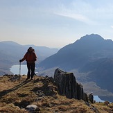
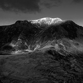
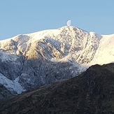
Y Garn (Glyderau) Photos
View all
Snowdonia photos (206) |
Cambrian Mountains photos (384) |
photos from mountains in United Kingdom (2125) |
all photos
 Upload new photo
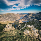

 See 15 more Y Garn (Glyderau) photos
Nearing summit
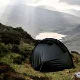
Great camp spot
Heading up Y garn
Y Garn at sunrise
Moon landing
Y garn on a cloudy sunrise
Heading up y garn in -4