– Lat/Long: 37.86° N 107.98° W
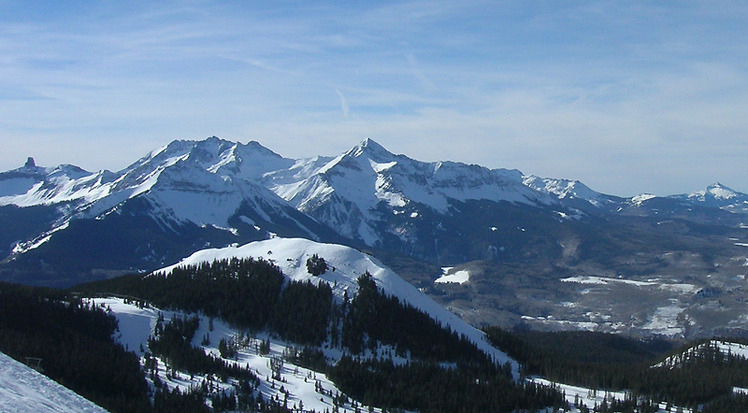
 Wilson Peak
Weather Forecast, United StatesIssued: 11 am Mon 06 Jul Local TimeUpdates in: hr min sUpdate imminent
Issued: 11 am Mon 06 Jul Local Time
Updates in:
Update imminent hr min s

Issued: 11 am Mon 06 Jul Local Time
Updates in:
Update imminent hr min s
Days 1–3 Weather SummaryLight rain (total 3mm), mostly falling on Mon afternoon. Very mild (max 11°C on Wed morning, min 4°C on Mon night). Winds increasing (light winds from the SSW on Mon night, fresh winds from the WNW by Wed afternoon). | Days 4–6 Weather SummaryMostly dry. Very mild (max 13°C on Sat afternoon, min 5°C on Thu night). Winds decreasing (fresh winds from the WNW on Thu afternoon, calm by Sat afternoon). | |||||||||||||||||
Monday 6 | Tuesday 7 | Wednesday 8 | Thursday 9 | Friday 10 | Saturday 11 | |||||||||||||
AM | PM | night | AM | PM | night | AM | PM | night | AM | PM | night | AM | PM | night | AM | PM | night | |
some clouds | rain shwrs | rain shwrs | rain shwrs | risk tstorm | some clouds | some clouds | some clouds | some clouds | some clouds | some clouds | clear | some clouds | cloudy | some clouds | some clouds | some clouds | clear | |
km/h | ||||||||||||||||||
 |  |  |  |  |  | |||||||||||||
— | — | — | — | — | — | — | — | — | — | — | — | — | — | — | — | — | — | |
mm | — | 2 | 0.6 | 0.1 | 0.3 | — | — | — | — | — | — | — | — | — | — | — | — | — |
max °C | 9 | 8 | 6 | 9 | 10 | 8 | 11 | 11 | 8 | 10 | 11 | 7 | 10 | 10 | 8 | 12 | 13 | 9 |
min °C | 8 | 5 | 4 | 8 | 10 | 5 | 8 | 11 | 5 | 8 | 11 | 5 | 9 | 10 | 6 | 10 | 12 | 6 |
chill °C | 7 | 2 | 2 | 6 | 8 | 2 | 5 | 8 | 1 | 5 | 8 | 3 | 7 | 9 | 5 | 9 | 12 | 4 |
Freezing level m | 5200 | 5250 | 5050 | 5300 | 5500 | 5200 | 5300 | 5500 | 5150 | 5250 | 5400 | 5100 | 5200 | 5450 | 5150 | 5350 | 5650 | 5350 |
Cloud base (m) | 5350 | 5550 | 6250 | 5400 | 5450 | 5350 | 5950 | 6000 | 5700 | 6450 | 6850 | 6250 | 6350 | 6800 | 6650 | 6450 | ||
5:54 | — | — | 5:56 | — | — | 5:56 | — | — | 5:56 | — | — | 5:58 | — | — | 5:58 | — | — | |
— | 8:37 | — | — | 8:37 | — | — | 8:36 | — | — | 8:36 | — | — | 8:36 | — | — | 8:35 | — | |
Loading...
Wilson Peak Weather (Days 0-3):
The weather forecast for Wilson Peak is: Light rain (total 3mm), mostly falling on Mon afternoon. Very mild (max 11°C on Wed morning, min 4°C on Mon night). Winds increasing (light winds from the SSW on Mon night, fresh winds from the WNW by Wed afternoon).
Wilson Peak Weather (Days 3-6):
Mostly dry. Very mild (max 13°C on Sat afternoon, min 5°C on Thu night). Winds decreasing (fresh winds from the WNW on Thu afternoon, calm by Sat afternoon).
This table gives the weather forecast for Wilson Peak at the specific elevation of 4272 m. Our advanced weather models allow us to provide distinct weather forecasts for several elevations of Wilson Peak. To see the weather forecasts for the other elevations, use the tab navigation above the table. For a wider overview of the weather, consult the Weather Map of Colorado.
| Weather Station | Temp. | Weather | Wind | Gusts | Cloud / Visibility |
|---|---|---|---|---|---|
lightning 29km NNE of Mancos | |||||
* NOTE: not all weather observatories update at the same frequency which is the reason why some locations may show data from stations that are further away than known closer ones.
