
– Lat/Long: 53.13° N 168.68° W
 Vsevidof
Weather Forecast, United StatesIssued: 9 pm Mon 13 Jul Local TimeUpdates in: hr min sUpdate imminent
Issued: 9 pm Mon 13 Jul Local Time
Updates in:
Update imminent hr min s

Issued: 9 pm Mon 13 Jul Local Time
Updates in:
Update imminent hr min s
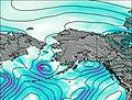
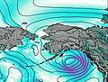
Days 1–4 Weather SummaryA dusting of snow giving way to moderate rain (total 18mm) heaviest on Wed morning. Freeze-thaw conditions (max 4°C on Wed morning, min -2°C on Wed night). Winds increasing (strong winds from the SW on Tue night, gales from the WSW by Wed afternoon). | Days 5–7 Weather SummaryA moderate fall of snow, heaviest on Thu night. Freeze-thaw conditions (max 1°C on Fri morning, min -4°C on Sat afternoon). Mainly strong winds. | ||||||||||||||||||
Tuesday 14 | Wednesday 15 | Thursday 16 | Friday 17 | Saturday 18 | Sunday 19 | ||||||||||||||
night | AM | PM | night | AM | PM | night | AM | PM | night | AM | PM | night | AM | PM | night | AM | PM | night | |
light rain | some clouds | some clouds | light snow | mod. rain | light rain | some clouds | some clouds | some clouds | snow shwrs | light snow | cloudy | some clouds | some clouds | some clouds | cloudy | cloudy | cloudy | cloudy | |
km/h | |||||||||||||||||||
 |  |  |  |  |  |  | |||||||||||||
— | — | — | 1 | — | — | — | — | — | 6 | 5 | — | — | — | — | — | — | — | — | |
mm | 1.4 | — | — | 4 | 10 | 3 | — | — | — | — | — | — | — | — | — | — | — | — | — |
max °C | 2 | 0 | 0 | 2 | 4 | 3 | 0 | -2 | -1 | -2 | 1 | 1 | 1 | -3 | -4 | -3 | -3 | -3 | -3 |
min °C | 1 | -1 | 0 | 1 | 2 | 2 | -2 | -2 | -2 | -3 | -1 | 1 | -3 | -3 | -4 | -4 | -4 | -3 | -4 |
chill °C | -7 | -9 | -8 | -6 | -6 | -5 | -11 | -11 | -10 | -11 | -10 | -5 | -11 | -11 | -12 | -13 | -12 | -9 | -12 |
Freezing level m | 2750 | 2200 | 2300 | 2550 | 3350 | 2800 | 1550 | 1450 | 1800 | 1550 | 1550 | 2450 | 2150 | 1350 | 1350 | 1350 | 1300 | 1400 | 1550 |
Cloud base (m) | 200 | 200 | 200 | 150 | 150 | 150 | 150 | 250 | 350 | 450 | 150 | 150 | 350 | 300 | 200 | 150 | 150 | 150 | 150 |
— | 7:05 | — | — | 7:05 | — | — | 7:07 | — | — | 7:09 | — | — | 7:09 | — | — | 7:11 | — | — | |
— | — | — | 11:35 | — | — | 11:34 | — | — | 11:31 | — | — | 11:30 | — | — | 11:30 | — | — | 11:29 | |
Loading...
Vsevidof Weather (Days 0-3):
The weather forecast for Vsevidof is: A dusting of snow giving way to moderate rain (total 18mm) heaviest on Wed morning. Freeze-thaw conditions (max 4°C on Wed morning, min -2°C on Wed night). Winds increasing (strong winds from the SW on Tue night, gales from the WSW by Wed afternoon).
Vsevidof Weather (Days 3-6):
A moderate fall of snow, heaviest on Thu night. Freeze-thaw conditions (max 1°C on Fri morning, min -4°C on Sat afternoon). Mainly strong winds.
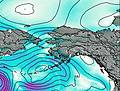
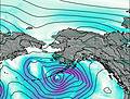
This table gives the weather forecast for Vsevidof at the specific elevation of 2149 m. Our advanced weather models allow us to provide distinct weather forecasts for several elevations of Vsevidof. To see the weather forecasts for the other elevations, use the tab navigation above the table. For a wider overview of the weather, consult the Weather Map of Alaska United States.