
– Lat/Long: 62.48° N 7.74° E
 Trollryggen
Weather Forecast, NorwayIssued: 7 am Mon 03 Aug Local TimeUpdates in: hr min sUpdate imminent
Issued: 7 am Mon 03 Aug Local Time
Updates in:
Update imminent hr min s

Issued: 7 am Mon 03 Aug Local Time
Updates in:
Update imminent hr min s
Days 1–3 Weather SummaryA dusting of snow turning to light rain (total 3mm) on Wed night. Freeze-thaw conditions (max 7°C on Wed afternoon, min -2°C on Mon morning). Wind will be generally light. | Days 4–6 Weather SummaryLight rain (total 7mm) at first, then becoming colder with a dusting of snow on Sat night. Temperatures will be slightly above freezing (max 4°C on Thu morning, min 1°C on Thu night). Wind will be generally light. | |||||||||||||||||
Monday 3 | Tuesday 4 | Wednesday 5 | Thursday 6 | Friday 7 | Saturday 8 | |||||||||||||
AM | PM | night | AM | PM | night | AM | PM | night | AM | PM | night | AM | PM | night | AM | PM | night | |
light snow | light snow | some clouds | clear | some clouds | rain shwrs | rain shwrs | cloudy | light rain | light rain | rain shwrs | rain shwrs | cloudy | rain shwrs | some clouds | cloudy | light rain | snow shwrs | |
Cloud base (m) | 550 | 550 | 850 | 1650 | 1950 | 2300 | 1650 | 1800 | 500 | 500 | 1450 | 650 | 900 | 1900 | 800 | 2500 | 700 | 750 |
km/h | ||||||||||||||||||
 |  |  |  |  |  | |||||||||||||
2 | 1 | — | — | — | — | — | — | — | — | — | — | — | — | — | — | — | 1 | |
mm | — | — | — | — | — | 0.6 | 0.2 | — | 2 | 0.9 | 1.4 | 1 | — | 0.1 | — | — | 1.5 | 2 |
max °C | -1 | 0 | 1 | 1 | 4 | 5 | 4 | 7 | 7 | 4 | 4 | 3 | 1 | 3 | 3 | 4 | 3 | 3 |
min °C | -2 | -1 | 0 | 0 | 4 | 4 | 4 | 6 | 6 | 4 | 4 | 1 | 1 | 3 | 2 | 3 | 3 | 1 |
chill °C | -7 | -6 | -4 | -2 | 4 | 4 | 2 | 6 | 6 | 1 | 1 | -1 | 1 | 3 | 2 | 0 | -1 | -4 |
Freezing level m | 1500 | 1700 | 1800 | 1950 | 2400 | 2350 | 2700 | 2900 | 2750 | 2500 | 2300 | 2100 | 2000 | 2200 | 2100 | 2300 | 2200 | 2000 |
4:54 | — | — | 4:56 | — | — | 5:00 | — | — | 5:03 | — | — | 5:05 | — | — | 5:07 | — | — | |
— | — | 10:13 | — | — | 10:09 | — | — | 10:07 | — | — | 10:04 | — | — | 10:00 | — | — | 9:58 | |
Loading...
Trollryggen Weather (Days 0-3):
The weather forecast for Trollryggen is: A dusting of snow turning to light rain (total 3mm) on Wed night. Freeze-thaw conditions (max 7°C on Wed afternoon, min -2°C on Mon morning). Wind will be generally light.
Trollryggen Weather (Days 3-6):
Light rain (total 7mm) at first, then becoming colder with a dusting of snow on Sat night. Temperatures will be slightly above freezing (max 4°C on Thu morning, min 1°C on Thu night). Wind will be generally light.
This table gives the weather forecast for Trollryggen at the specific elevation of 1700 m. Our advanced weather models allow us to provide distinct weather forecasts for several elevations of Trollryggen. To see the weather forecasts for the other elevations, use the tab navigation above the table. For a wider overview of the weather, consult the Weather Map of Norway.
| Weather Station | Temp. | Weather | Wind | Gusts | Cloud / Visibility |
|---|---|---|---|---|---|
Marstein | |||||
RPK Nesaksla | |||||
Romsdalsgondolen Fje | |||||
Romsdalsgondolen Fjo | |||||
Bjorli | |||||
Vestnes KRIK | |||||
Molde lufthavn/Årø Airport | |||||
Molde AP | |||||
Molde-Tusten |
* NOTE: not all weather observatories update at the same frequency which is the reason why some locations may show data from stations that are further away than known closer ones.
Trollryggen Photos
View all
Scandinavia/European Arctic Ranges photos (16) |
photos from mountains in Norway (115) |
all photos
 Upload new photo
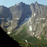
Trollryggen