
– Lat/Long: 49.87° N 91.00° W
 Sturgeon Lake Caldera
Weather Forecast, CanadaIssued: 7 am Mon 03 Aug Local TimeUpdates in: hr min sUpdate imminent
Issued: 7 am Mon 03 Aug Local Time
Updates in:
Update imminent hr min s

Issued: 7 am Mon 03 Aug Local Time
Updates in:
Update imminent hr min s
Days 1–3 Weather SummaryHeavy rain (total 22mm), heaviest during Mon night. Warm (max 25°C on Mon afternoon, min 11°C on Tue night). Winds increasing (calm on Mon night, fresh winds from the SW by Wed night). | Days 4–6 Weather SummaryLight rain (total 4mm), mostly falling on Sat afternoon. Warm (max 27°C on Thu afternoon, min 10°C on Thu night). Winds decreasing (fresh winds from the WSW on Thu afternoon, calm by Sat afternoon). | |||||||||||||||||
Monday 3 | Tuesday 4 | Wednesday 5 | Thursday 6 | Friday 7 | Saturday 8 | |||||||||||||
AM | PM | night | AM | PM | night | AM | PM | night | AM | PM | night | AM | PM | night | AM | PM | night | |
rain shwrs | light rain | heavy rain | rain shwrs | clear | some clouds | clear | some clouds | clear | some clouds | some clouds | clear | some clouds | some clouds | some clouds | light rain | rain shwrs | rain shwrs | |
Cloud base (m) | 9350 | 850 | 450 | 2400 | 2600 | 2850 | 2950 | 3150 | 2600 | 2550 | 7100 | 2500 | 350 | 2200 | ||||
km/h | ||||||||||||||||||
 |  |  |  |  |  | |||||||||||||
— | — | — | — | — | — | — | — | — | — | — | — | — | — | — | — | — | — | |
mm | 1.5 | 0.2 | 20 | 1.1 | — | — | — | — | — | — | — | — | — | — | — | 0.1 | 1.9 | 1.5 |
max °C | 21 | 25 | 20 | 13 | 19 | 19 | 18 | 23 | 22 | 22 | 27 | 18 | 16 | 20 | 20 | 15 | 16 | 16 |
min °C | 17 | 24 | 14 | 13 | 17 | 11 | 12 | 21 | 18 | 19 | 25 | 10 | 11 | 19 | 14 | 14 | 15 | 11 |
chill °C | 16 | 24 | 12 | 11 | 16 | 9 | 11 | 21 | 17 | 18 | 25 | 8 | 9 | 19 | 14 | 14 | 15 | 9 |
Freezing level m | 4600 | 4150 | 4100 | 3300 | 2550 | 2600 | 2650 | 2950 | 3400 | 3600 | 3650 | 3450 | 3200 | 2800 | 3500 | 3550 | 3500 | 2600 |
6:35 | — | — | 6:37 | — | — | 6:37 | — | — | 6:39 | — | — | 6:41 | — | — | 6:43 | — | — | |
— | — | 9:43 | — | — | 9:40 | — | — | 9:39 | — | — | 9:37 | — | — | 9:36 | — | — | 9:35 | |
Loading...
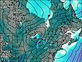
Sturgeon Lake Caldera Weather (Days 0-3):
The weather forecast for Sturgeon Lake Caldera is: Heavy rain (total 22mm), heaviest during Mon night. Warm (max 25°C on Mon afternoon, min 11°C on Tue night). Winds increasing (calm on Mon night, fresh winds from the SW by Wed night).
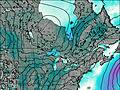
Sturgeon Lake Caldera Weather (Days 3-6):
Light rain (total 4mm), mostly falling on Sat afternoon. Warm (max 27°C on Thu afternoon, min 10°C on Thu night). Winds decreasing (fresh winds from the WSW on Thu afternoon, calm by Sat afternoon).
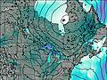
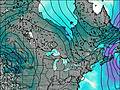
This table gives the weather forecast for Sturgeon Lake Caldera at the specific elevation of 455 m. Our advanced weather models allow us to provide distinct weather forecasts for several elevations of Sturgeon Lake Caldera. To see the weather forecasts for the other elevations, use the tab navigation above the table. For a wider overview of the weather, consult the Weather Map of Ontario.
| Weather Station | Temp. | Weather | Wind | Gusts | Cloud / Visibility |
|---|---|---|---|---|---|
Sioux Lookout A- Ont | |||||
Upsala (Aut)- Ont | |||||
Upsala Airport | |||||
Dryden Regional- Ont | |||||
Dryden Airport | |||||
Atikokan (Aut)- Ont | |||||
Armstrong (Aut)- Ont | |||||
Ear Falls Airport |
* NOTE: not all weather observatories update at the same frequency which is the reason why some locations may show data from stations that are further away than known closer ones.