– Lat/Long: 40.60° N 115.40° W
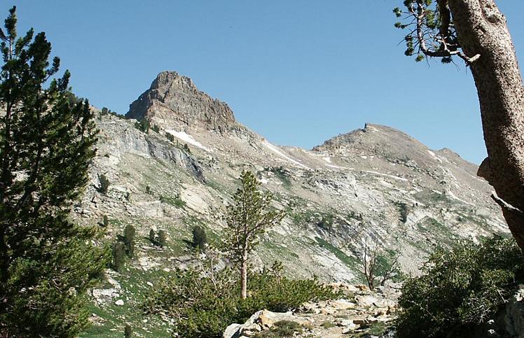
 Snow Lake Peak
Weather Forecast, United StatesIssued: 4 pm Fri 17 Jul Local TimeUpdates in: hr min sUpdate imminent
Issued: 4 pm Fri 17 Jul Local Time
Updates in:
Update imminent hr min s

Issued: 4 pm Fri 17 Jul Local Time
Updates in:
Update imminent hr min s
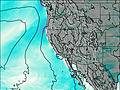
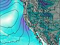
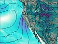
Days 1–4 Weather SummaryLight rain (total 3mm), mostly falling on Sun night. Very mild (max 17°C on Sat afternoon, min 13°C on Fri night). Wind will be generally light. | Days 5–7 Weather SummaryHeavy rain (total 35mm), heaviest during Tue night. Very mild (max 17°C on Mon afternoon, min 10°C on Tue night). Wind will be generally light. | ||||||||||||||||
Fri 17 | Saturday 18 | Sunday 19 | Monday 20 | Tuesday 21 | Wednesday 22 | ||||||||||||
PM | night | AM | PM | night | AM | PM | night | AM | PM | night | AM | PM | night | AM | PM | night | |
risk tstorm | rain shwrs | clear | risk tstorm | some clouds | clear | rain shwrs | rain shwrs | clear | rain shwrs | rain shwrs | clear | rain shwrs | heavy rain | rain shwrs | risk tstorm | risk tstorm | |
Cloud base (m) | 4850 | 5950 | 5250 | 5150 | 5350 | 5300 | 4900 | 5150 | 5050 | 5950 | 4650 | 2250 | 3800 | 9250 | |||
km/h | |||||||||||||||||
 |  |  |  |  |  | ||||||||||||
— | — | — | — | — | — | — | — | — | — | — | — | — | — | — | — | — | |
mm | 0.1 | 0.3 | — | 0.4 | — | — | 0.3 | 1.9 | — | 0.1 | 12 | — | 0.2 | 17 | 0.9 | 4 | 0.7 |
max °C | 16 | 15 | 13 | 17 | 16 | 15 | 17 | 15 | 15 | 17 | 13 | 12 | 15 | 11 | 10 | 11 | 12 |
min °C | 14 | 13 | 13 | 16 | 14 | 14 | 16 | 14 | 15 | 17 | 12 | 12 | 14 | 10 | 10 | 10 | 12 |
chill °C | 12 | 12 | 13 | 16 | 14 | 14 | 16 | 14 | 14 | 17 | 11 | 12 | 13 | 9 | 9 | 9 | 12 |
Freezing level m | 5500 | 5350 | 5250 | 5550 | 5450 | 5500 | 5750 | 5500 | 5550 | 5750 | 5350 | 5250 | 5600 | 5150 | 5000 | 5250 | 5200 |
— | — | 5:24 | — | — | 5:26 | — | — | 5:26 | — | — | 5:28 | — | — | 5:28 | — | — | |
— | 8:09 | — | — | 8:08 | — | — | 8:07 | — | — | 8:07 | — | — | 8:07 | — | — | 8:06 | |
Loading...
Snow Lake Peak Weather (Days 0-3):
The weather forecast for Snow Lake Peak is: Light rain (total 3mm), mostly falling on Sun night. Very mild (max 17°C on Sat afternoon, min 13°C on Fri night). Wind will be generally light.
Snow Lake Peak Weather (Days 3-6):
Heavy rain (total 35mm), heaviest during Tue night. Very mild (max 17°C on Mon afternoon, min 10°C on Tue night). Wind will be generally light.
This table gives the weather forecast for Snow Lake Peak at the specific elevation of 3394 m. Our advanced weather models allow us to provide distinct weather forecasts for several elevations of Snow Lake Peak. To see the weather forecasts for the other elevations, use the tab navigation above the table. For a wider overview of the weather, consult the Weather Map of Nevada.
| Weather Station | Temp. | Weather | Wind | Gusts | Cloud / Visibility |
|---|---|---|---|---|---|
lightning 26km ENE of Spring Creek | |||||
Elko Airport | |||||
lightning 35km NNW of McGill | |||||
Battle Mountain Airport | |||||
Ely Airport | |||||
Austin Airport (Nevada) | |||||
Eagle Range | |||||
* NOTE: not all weather observatories update at the same frequency which is the reason why some locations may show data from stations that are further away than known closer ones.
Snow Lake Peak Photos
View all
Ruby Mountains photos (2) |
Intermountain West photos (151) |
photos from mountains in United States (3055) |
all photos
 Upload new photo
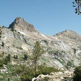
Snow Lake Peak