– Lat/Long: 2.03° S 78.33° W
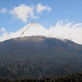
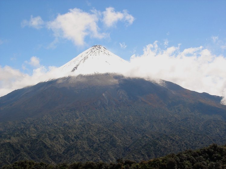
 Sangay
Weather Forecast, EcuadorIssued: 6 am Sat 01 Aug Local TimeUpdates in: hr min sUpdate imminent
Issued: 6 am Sat 01 Aug Local Time
Updates in:
Update imminent hr min s

Issued: 6 am Sat 01 Aug Local Time
Updates in:
Update imminent hr min s
Days 1–3 Weather SummaryLight rain (total 2mm) at first, then becoming colder with a dusting of snow on Sat afternoon. Freeze-thaw conditions (max 2°C on Sat morning, min 0°C on Sun night). Wind will be generally light. | Days 4–6 Weather SummaryMostly dry. Freeze-thaw conditions (max 2°C on Tue afternoon, min 0°C on Tue night). Wind will be generally light. | |||||||||||||||||
Saturday 1 | Sunday 2 | Monday 3 | Tuesday 4 | Wednesday 5 | Thursday 6 | |||||||||||||
AM | PM | night | AM | PM | night | AM | PM | night | AM | PM | night | AM | PM | night | AM | PM | night | |
rain shwrs | snow shwrs | clear | snow shwrs | snow shwrs | clear | rain shwrs | snow shwrs | clear | some clouds | some clouds | some clouds | some clouds | some clouds | some clouds | some clouds | some clouds | some clouds | |
Cloud base (m) | 3050 | 2400 | 2700 | 2750 | 2400 | 3200 | 2900 | 2850 | 2700 | 2800 | 2450 | 2900 | 3500 | 2850 | 3000 | 3400 | ||
km/h | ||||||||||||||||||
 |  |  |  |  |  | |||||||||||||
— | 1 | — | 1 | 1 | — | — | 1 | — | — | — | — | — | — | — | — | — | — | |
mm | 1.5 | — | — | — | — | — | 0.5 | — | — | — | — | — | — | — | — | — | — | — |
max °C | 2 | 2 | 1 | 2 | 2 | 1 | 2 | 2 | 1 | 1 | 2 | 1 | 1 | 2 | 1 | 2 | 2 | 2 |
min °C | 1 | 2 | 1 | 1 | 1 | 0 | 2 | 2 | 0 | 1 | 1 | 0 | 1 | 2 | 1 | 1 | 2 | 1 |
chill °C | -1 | 2 | -2 | -2 | -2 | -4 | -1 | -2 | -2 | 0 | -1 | 0 | 1 | 2 | 1 | -2 | -1 | -2 |
Freezing level m | 4750 | 4850 | 4650 | 4700 | 4800 | 4700 | 4800 | 4850 | 4650 | 4750 | 4800 | 4650 | 4600 | 4800 | 4750 | 4800 | 4900 | 4850 |
6:18 | — | — | 6:18 | — | — | 6:18 | — | — | 6:18 | — | — | 6:18 | — | — | 6:18 | — | — | |
— | 6:20 | — | — | 6:20 | — | — | 6:20 | — | — | 6:20 | — | — | 6:20 | — | — | 6:20 | — | |
Loading...
Sangay Weather (Days 0-3):
The weather forecast for Sangay is: Light rain (total 2mm) at first, then becoming colder with a dusting of snow on Sat afternoon. Freeze-thaw conditions (max 2°C on Sat morning, min 0°C on Sun night). Wind will be generally light.
Sangay Weather (Days 3-6):
Mostly dry. Freeze-thaw conditions (max 2°C on Tue afternoon, min 0°C on Tue night). Wind will be generally light.
This table gives the weather forecast for Sangay at the specific elevation of 4500 m. Our advanced weather models allow us to provide distinct weather forecasts for several elevations of Sangay. To see the weather forecasts for the other elevations, use the tab navigation above the table. For a wider overview of the weather, consult the Weather Map of Ecuador.
| Weather Station | Temp. | Weather | Wind | Gusts | Cloud / Visibility |
|---|---|---|---|---|---|
Maca / dmundo Carvajal Airportl | |||||
Shell Mera Airport | |||||
Cuenc / ariscal Airport | |||||
Quito New International Airport | |||||
Coc / rancisco Airport | |||||
Machala Larrea Airport |
* NOTE: not all weather observatories update at the same frequency which is the reason why some locations may show data from stations that are further away than known closer ones.