
– Lat/Long: 43.47° N 71.83° W
 Ragged Mountain (New Hampshire)
Weather Forecast, United StatesIssued: 1 am Mon 03 Aug Local TimeUpdates in: hr min sUpdate imminent
Issued: 1 am Mon 03 Aug Local Time
Updates in:
Update imminent hr min s

Issued: 1 am Mon 03 Aug Local Time
Updates in:
Update imminent hr min s
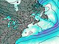
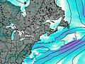
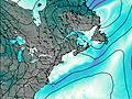
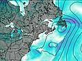
Days 1–3 Weather SummaryModerate rain (total 12mm), heaviest on Mon morning. Warm (max 25°C on Wed afternoon, min 15°C on Mon night). Winds decreasing (near gales from the NW on Mon night, calm by Tue night). | Days 4–6 Weather SummaryLight rain (total 2mm), mostly falling on Thu night. Warm (max 28°C on Fri afternoon, min 19°C on Sat night). Wind will be generally light. | |||||||||||||||||
Monday 3 | Tuesday 4 | Wednesday 5 | Thursday 6 | Friday 7 | Saturday 8 | |||||||||||||
AM | PM | night | AM | PM | night | AM | PM | night | AM | PM | night | AM | PM | night | AM | PM | night | |
mod. rain | risk tstorm | rain shwrs | clear | clear | clear | some clouds | some clouds | some clouds | clear | some clouds | risk tstorm | some clouds | some clouds | rain shwrs | clear | some clouds | risk tstorm | |
Cloud base (m) | 200 | 400 | 7350 | 6000 | 5200 | 2300 | 4200 | 4150 | 2250 | 4200 | 8550 | 2100 | 9300 | |||||
km/h | ||||||||||||||||||
 |  |  |  |  |  | |||||||||||||
— | — | — | — | — | — | — | — | — | — | — | — | — | — | — | — | — | — | |
mm | 8 | 4 | 0.1 | — | — | — | — | — | — | — | — | 2 | — | — | 0.1 | — | — | 0.1 |
max °C | 20 | 21 | 17 | 20 | 24 | 20 | 22 | 25 | 22 | 25 | 27 | 23 | 24 | 28 | 23 | 23 | 26 | 22 |
min °C | 19 | 19 | 15 | 18 | 24 | 17 | 19 | 25 | 18 | 21 | 26 | 21 | 22 | 26 | 20 | 21 | 25 | 19 |
chill °C | 18 | 18 | 12 | 17 | 24 | 17 | 19 | 25 | 18 | 21 | 26 | 21 | 22 | 26 | 20 | 21 | 25 | 19 |
Freezing level m | 4650 | 4650 | 4350 | 4700 | 4850 | 4900 | 4800 | 5050 | 4850 | 4700 | 4850 | 4650 | 4650 | 4700 | 4500 | 4450 | 4400 | 4600 |
5:37 | — | — | 5:39 | — | — | 5:39 | — | — | 5:41 | — | — | 5:41 | — | — | 5:43 | — | — | |
— | — | 8:07 | — | — | 8:06 | — | — | 8:05 | — | — | 8:02 | — | — | 8:01 | — | — | 8:00 | |
Loading...
Ragged Mountain (New Hampshire) Weather (Days 0-3):
The weather forecast for Ragged Mountain (New Hampshire) is: Moderate rain (total 12mm), heaviest on Mon morning. Warm (max 25°C on Wed afternoon, min 15°C on Mon night). Winds decreasing (near gales from the NW on Mon night, calm by Tue night).
Ragged Mountain (New Hampshire) Weather (Days 3-6):
Light rain (total 2mm), mostly falling on Thu night. Warm (max 28°C on Fri afternoon, min 19°C on Sat night). Wind will be generally light.
This table gives the weather forecast for Ragged Mountain (New Hampshire) at the specific elevation of 697 m. Our advanced weather models allow us to provide distinct weather forecasts for several elevations of Ragged Mountain (New Hampshire). To see the weather forecasts for the other elevations, use the tab navigation above the table. For a wider overview of the weather, consult the Weather Map of New-Hampshire.