– Lat/Long: 50.99° N 118.87° W
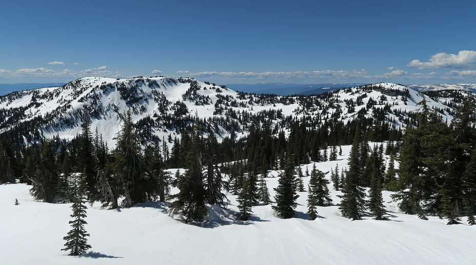
 Queest Mountain
Weather Forecast, CanadaIssued: 10 pm Sun 02 Aug Local TimeUpdates in: hr min sUpdate imminent
Issued: 10 pm Sun 02 Aug Local Time
Updates in:
Update imminent hr min s

Issued: 10 pm Sun 02 Aug Local Time
Updates in:
Update imminent hr min s
Days 1–4 Weather SummaryMostly dry. Warm (max 31°C on Wed afternoon, min 10°C on Sun night). Wind will be generally light. | Days 5–7 Weather SummaryMostly dry. Warm (max 32°C on Thu afternoon, min 15°C on Fri night). Wind will be generally light. | ||||||||||||||||||
Monday 3 | Tuesday 4 | Wednesday 5 | Thursday 6 | Friday 7 | Saturday 8 | ||||||||||||||
night | AM | PM | night | AM | PM | night | AM | PM | night | AM | PM | night | AM | PM | night | AM | PM | night | |
some clouds | clear | clear | clear | clear | clear | clear | clear | clear | clear | clear | clear | some clouds | clear | rain shwrs | clear | clear | some clouds | rain shwrs | |
Cloud base (m) | 2650 | 2600 | 2850 | 8650 | 8750 | 6600 | 6200 | 5000 | 3500 | 3400 | 4500 | ||||||||
km/h | |||||||||||||||||||
 |  |  |  |  |  |  | |||||||||||||
— | — | — | — | — | — | — | — | — | — | — | — | — | — | — | — | — | — | — | |
mm | — | — | — | — | — | — | — | — | — | — | — | — | — | — | 0.3 | — | — | — | 3 |
max °C | 16 | 17 | 23 | 21 | 22 | 27 | 24 | 26 | 31 | 27 | 27 | 32 | 29 | 26 | 31 | 22 | 23 | 27 | 23 |
min °C | 10 | 12 | 21 | 14 | 17 | 25 | 17 | 21 | 30 | 20 | 22 | 31 | 21 | 22 | 28 | 15 | 18 | 26 | 15 |
chill °C | 10 | 12 | 21 | 14 | 17 | 25 | 17 | 21 | 30 | 20 | 22 | 31 | 21 | 22 | 28 | 15 | 18 | 26 | 15 |
Freezing level m | 2600 | 2850 | 3100 | 3300 | 3400 | 3700 | 4050 | 4100 | 4350 | 4500 | 4300 | 4400 | 4450 | 4000 | 4100 | 3700 | 3600 | 3750 | 3700 |
— | 5:22 | — | — | 5:24 | — | — | 5:26 | — | — | 5:28 | — | — | 5:28 | — | — | 5:31 | — | — | |
— | — | — | 8:37 | — | — | 8:37 | — | — | 8:35 | — | — | 8:32 | — | — | 8:30 | — | — | 8:30 | |
Loading...
Queest Mountain Weather (Days 0-3):
The weather forecast for Queest Mountain is: Mostly dry. Warm (max 31°C on Wed afternoon, min 10°C on Sun night). Wind will be generally light.
Queest Mountain Weather (Days 3-6):
Mostly dry. Warm (max 32°C on Thu afternoon, min 15°C on Fri night). Wind will be generally light.
This table gives the weather forecast for Queest Mountain at the specific elevation of 500 m. Our advanced weather models allow us to provide distinct weather forecasts for several elevations of Queest Mountain. To see the weather forecasts for the other elevations, use the tab navigation above the table. For a wider overview of the weather, consult the Weather Map of British-Columbia.
| Weather Station | Temp. | Weather | Wind | Gusts | Cloud / Visibility |
|---|---|---|---|---|---|
Salmon Arm Airport | |||||
Salmon Arm Cs- BC | |||||
Revelstoke A- BC (71685 -0) | |||||
Revelstoke Airport | |||||
Vernon Auto- BC | |||||
Vernon Airport | |||||
Nakusp Airport | |||||
Clearwater Auto- BC | |||||
* NOTE: not all weather observatories update at the same frequency which is the reason why some locations may show data from stations that are further away than known closer ones.
Queest Mountain Photos
View all
British Columbia Interior photos (2) |
Intermountain West photos (151) |
photos from mountains in Canada (457) |
all photos
 Upload new photo
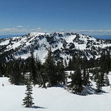
Queest Mountain