– Lat/Long: 37.09° S 12.28° W
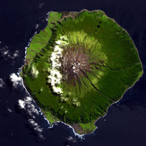
 Queen Mary's Peak (Queen Mary-s Peak)
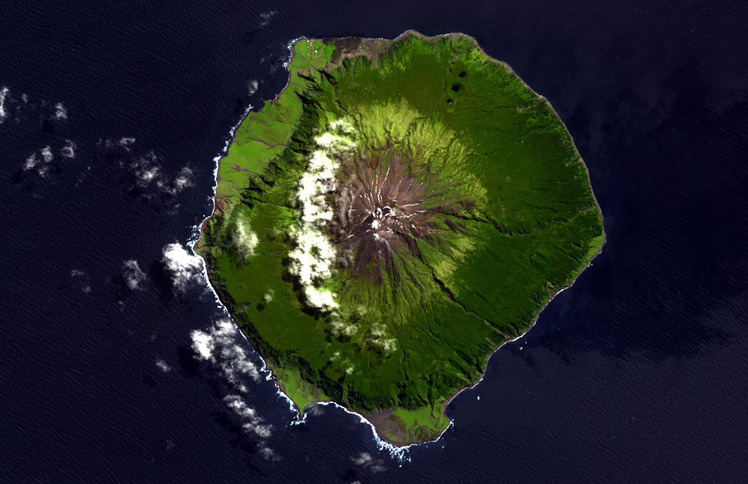
Weather Forecast, Tristan Da CunhaIssued: 11 am Mon 03 Aug Local TimeUpdates in: hr min sUpdate imminent
Issued: 11 am Mon 03 Aug Local Time
Updates in:
Update imminent hr min s

Issued: 11 am Mon 03 Aug Local Time
Updates in:
Update imminent hr min s
Days 1–3 Weather SummaryModerate rain (total 11mm) heaviest on Mon night, then becoming colder with a dusting of snow on Tue morning. Freeze-thaw conditions (max 7°C on Mon afternoon, min -6°C on Tue night). Winds decreasing (stormy winds from the W on Mon morning, moderate winds from the WSW by Wed morning). | Days 4–6 Weather SummaryModerate rain (total 16mm), heaviest on Thu night. Mild temperatures (max 7°C on Thu night, min 1°C on Thu morning). Winds decreasing (stormy winds from the W on Thu night, calm by Sat night). | |||||||||||||||||
Monday 3 | Tuesday 4 | Wednesday 5 | Thursday 6 | Friday 7 | Saturday 8 | |||||||||||||
AM | PM | night | AM | PM | night | AM | PM | night | AM | PM | night | AM | PM | night | AM | PM | night | |
rain shwrs | light rain | rain shwrs | snow shwrs | some clouds | cloudy | some clouds | some clouds | some clouds | some clouds | light rain | heavy rain | rain shwrs | light rain | some clouds | clear | clear | some clouds | |
Cloud base (m) | 150 | 100 | 150 | 250 | 600 | 500 | 650 | 650 | 600 | 450 | 500 | 150 | 200 | 200 | 1600 | 450 | 2550 | 2550 |
km/h | ||||||||||||||||||
— | — | — | 1 | — | — | — | — | — | — | — | — | — | — | — | — | — | — | |
mm | 0.2 | 1.8 | 9 | — | — | — | — | — | — | — | 0.3 | 13 | 2 | 0.3 | — | — | — | — |
max °C | 6 | 7 | 5 | 0 | -3 | -5 | -5 | -3 | 1 | 2 | 4 | 7 | 7 | 7 | 6 | 6 | 6 | 7 |
min °C | 4 | 6 | 3 | -4 | -3 | -6 | -5 | -4 | -3 | 1 | 3 | 7 | 7 | 7 | 5 | 5 | 6 | 6 |
chill °C | -5 | -1 | -3 | -14 | -13 | -14 | -13 | -12 | -11 | -7 | -4 | 0 | 1 | 1 | 0 | 1 | 4 | 6 |
Freezing level m | 3400 | 2750 | 2600 | 1450 | 1150 | 900 | 900 | 1050 | 1300 | 1700 | 2350 | 2800 | 2700 | 2800 | 2850 | 2850 | 2900 | 3000 |
7:45 | — | — | 7:45 | — | — | 7:43 | — | — | 7:41 | — | — | 7:41 | — | — | 7:39 | — | — | |
— | 6:05 | — | — | 6:05 | — | — | 6:06 | — | — | 6:07 | — | — | 6:07 | — | — | 6:08 | — | |
Loading...
Queen Mary's Peak Weather (Days 0-3):
The weather forecast for Queen Mary's Peak is: Moderate rain (total 11mm) heaviest on Mon night, then becoming colder with a dusting of snow on Tue morning. Freeze-thaw conditions (max 7°C on Mon afternoon, min -6°C on Tue night). Winds decreasing (stormy winds from the W on Mon morning, moderate winds from the WSW by Wed morning).
Queen Mary's Peak Weather (Days 3-6):
Moderate rain (total 16mm), heaviest on Thu night. Mild temperatures (max 7°C on Thu night, min 1°C on Thu morning). Winds decreasing (stormy winds from the W on Thu night, calm by Sat night).
This table gives the weather forecast for Queen Mary's Peak at the specific elevation of 1500 m. Our advanced weather models allow us to provide distinct weather forecasts for several elevations of Queen Mary's Peak. To see the weather forecasts for the other elevations, use the tab navigation above the table.