
– Lat/Long: 68.85° S 90.58° W
 Peter I Island
Weather Forecast, AntarcticaIssued: 2 pm Sun 02 Aug Local TimeUpdates in: hr min sUpdate imminent
Issued: 2 pm Sun 02 Aug Local Time
Updates in:
Update imminent hr min s

Issued: 2 pm Sun 02 Aug Local Time
Updates in:
Update imminent hr min s
Days 1–4 Weather SummaryA dusting of new snow. Temperatures will be well below freezing (max -10°C on Sun afternoon, min -14°C on Sun night). Winds decreasing (near gales from the NNW on Tue afternoon, moderate winds from the NNW by Wed morning). | Days 5–7 Weather SummaryA light covering of new snow mostly falling on Wed afternoon. Extremely cold (max -12°C on Wed afternoon, min -16°C on Fri afternoon). Winds increasing (light winds from the NNW on Wed night, strong winds from the WSW by Fri afternoon). | ||||||||||||||||
Sun 2 | Monday 3 | Tuesday 4 | Wednesday 5 | Thursday 6 | Friday 7 | ||||||||||||
PM | night | AM | PM | night | AM | PM | night | AM | PM | night | AM | PM | night | AM | PM | night | |
clear | clear | clear | some clouds | clear | clear | clear | snow shwrs | light snow | light snow | light snow | some clouds | some clouds | cloudy | some clouds | cloudy | some clouds | |
Cloud base (m) | 250 | 250 | 150 | 350 | 150 | 50 | 50 | 0 | 150 | ||||||||
km/h | |||||||||||||||||
 |  |  |  |  |  | ||||||||||||
— | — | — | — | — | — | — | 2 | 2 | 3 | 2 | — | — | — | — | — | — | |
mm | — | — | — | — | — | — | — | — | — | — | — | — | — | — | — | — | — |
max °C | -10 | -10 | -14 | -13 | -11 | -11 | -11 | -10 | -11 | -12 | -13 | -13 | -12 | -13 | -14 | -16 | -14 |
min °C | -10 | -14 | -14 | -13 | -12 | -11 | -11 | -11 | -11 | -12 | -13 | -13 | -13 | -13 | -15 | -16 | -15 |
chill °C | -20 | -26 | -26 | -24 | -23 | -22 | -23 | -22 | -20 | -22 | -22 | -18 | -21 | -21 | -27 | -29 | -28 |
Freezing level m | 0 | 0 | 0 | 0 | 0 | 0 | 0 | 0 | 0 | 0 | 0 | 0 | 0 | 0 | 0 | 0 | 0 |
— | — | 12:29 | — | — | 12:23 | — | — | 12:18 | — | — | 12:15 | — | — | 12:10 | — | — | |
5:44 | — | — | 5:47 | — | — | 5:52 | — | — | 5:57 | — | — | 6:01 | — | — | 6:06 | — | |
Loading...
Peter I Island Weather (Days 0-3):
The weather forecast for Peter I Island is: A dusting of new snow. Temperatures will be well below freezing (max -10°C on Sun afternoon, min -14°C on Sun night). Winds decreasing (near gales from the NNW on Tue afternoon, moderate winds from the NNW by Wed morning).
Peter I Island Weather (Days 3-6):
A light covering of new snow mostly falling on Wed afternoon. Extremely cold (max -12°C on Wed afternoon, min -16°C on Fri afternoon). Winds increasing (light winds from the NNW on Wed night, strong winds from the WSW by Fri afternoon).
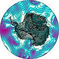
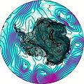
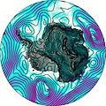
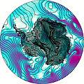
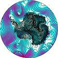
This table gives the weather forecast for Peter I Island at the specific elevation of 1640 m. Our advanced weather models allow us to provide distinct weather forecasts for several elevations of Peter I Island. To see the weather forecasts for the other elevations, use the tab navigation above the table. For a wider overview of the weather, consult the Weather Map of Antarctica.
| Weather Station | Temp. | Weather | Wind | Gusts | Cloud / Visibility |
|---|---|---|---|---|---|
Marambio Airport (Seymour Island) | |||||
Centro Met. Antártico Presidente Eduardo Frei | |||||
Teniente R. Marsh Airport | |||||
Dinamet | |||||
Ushuaia Naval Base Airport | |||||
Puerto Williams | |||||
Punta Arenas Unidad Aeropolicial | |||||
Instituto de la Patagonia (Jorge Schytte) | |||||
* NOTE: not all weather observatories update at the same frequency which is the reason why some locations may show data from stations that are further away than known closer ones.