Mount Stanley or Margherita Climbing Notes

Mount Stanley or Margherita climbing notes shared by Mountain-Forecast users
Click here to submit your own climbing note for Mount Stanley or Margherita
(NOTE: Texts may be edited by our content team for the purposes of ensuring accurate and relevant information)
-
March 20, 2013
Jørn Eriksson from Norway
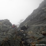
With an elevation of 5109 m it's the highest mountain in both Congo and Uganda and the third highest mountain on the continent after Mount Kenya and Mt Kilimanjaro. The peaks are actually high enough to support a glacier and it was named after explorer Sir Henry Morton Stanley. It's part of the UNESCO world heritage site that is Rwenzori Mountains National Park and was first summited in 1906 by Duke of the Abruzzi and his fellow climbers and was named Margherita Peak after the Queen Margherita of Italy.Mount Stanley is a mountain that should be taken serious, since there are no easy escapes down the mountain if altitude sickness or any injury. The help could be days away, and there are no medical support on the Mountain. We reached the summit in February 7th. As the glacier declines in high speed, most written route descriptions are not very useful as the guides has changed the route from Margerhita glacier and up to the peak. Even route descriptions being recently new is out of date. The only guidebook written on the topic does actually not describe this route since it was last updated in 2006. Earlier a ladder was used to get off the glacier, now it's a new crux traversing a few metres on some narrow outcrops before ascending up a fixed rope that will bring you up on the North West Ridge.
I found this climb less strenuous than Mt. Speke. The climb starts at Elena huts on about 4500 amsl. We started the climb in complete darkness, and it didn't take long before we reached steep ground, and a fixed rope, leading to the Stanley Glacier. The glacier is a pleasant walk on a plateau, roping was not needed, and snow was not very deep. Now the sun was up, so we could actually enjoy walking. Still the mist didn't give us much view. After a while we had to descend from the glacier around the foot of Alexandra peak, using another fixed rope (very good grips). From here we walked to the foot of the Margerhita Glacier where we put on crampons and roped up.
The Glacier is pretty steep. At one point I lost the camera on the snow, and had to throw my self after it like soccer goal keeper managing to save the precious photos before it descended to into the unknown. At this point the mist lifted and for about 10 minutes we had blue sky, sun and a clear view of the Bujuku valley and the two peaks Margerhita and Alexandra. It was a great scenery, and my best memory from the entire trek. At the upper parts of the glacier we traversed left over a crevasse on to a narrow ledge of rocky outcrops leading to a steep gully with a fixed rope. This section is the crux of the climb and pretty airy, and when we descended the rain we got had made the icy rocks very slippery making it difficult to traverse the ledge. It's a grade 5 YDS (must be roped) but a very short section. This route is fairly new and has only been in use the last few years. As the ice melts one will need to find new routes also in the future. As we came up the fixed rope the party was still roped together as a fall would be fatal. We then left the rope and took off the crampons as the rest of the way to summit was only a scramble. However it started raining when we were at the summit making me regret that I didn't bring the crampons up, because the water on the icy ground made the descent very unpleasant here. There was good room at the summit for photos, and we traversed the summit ridge further behind the big plate to a small cairn that shows the border between Uganda and Congo. This is a very exposed area so we had to be careful, and only two people could stand in Congo at the time as there was no more room, and steep drops on all sides. We followed the same route back, having an half hour break at Elena Hut before trekking 4 hours down to the beautiful Kitandara lake.
(NOTE: Texts may be edited by our content team for the purposes of ensuring accurate and relevant information)
Jørn Eriksson from Norway
With an elevation of 5109 m it's the highest mountain in both Congo and Uganda and the third highest mountain on the continent after Mount Kenya and Mt Kilimanjaro. The peaks are actually high enough to support a glacier and it was named after explorer Sir Henry Morton Stanley. It's part of the UNESCO world heritage site that is Rwenzori Mountains National Park and was first summited in 1906 by Duke of the Abruzzi and his fellow climbers and was named Margherita Peak after the Queen Margherita of Italy.Mount Stanley is a mountain that should be taken serious, since there are no easy escapes down the mountain if altitude sickness or any injury. The help could be days away, and there are no medical support on the Mountain. We reached the summit in February 7th. As the glacier declines in high speed, most written route descriptions are not very useful as the guides has changed the route from Margerhita glacier and up to the peak. Even route descriptions being recently new is out of date. The only guidebook written on the topic does actually not describe this route since it was last updated in 2006. Earlier a ladder was used to get off the glacier, now it's a new crux traversing a few metres on some narrow outcrops before ascending up a fixed rope that will bring you up on the North West Ridge.
I found this climb less strenuous than Mt. Speke. The climb starts at Elena huts on about 4500 amsl. We started the climb in complete darkness, and it didn't take long before we reached steep ground, and a fixed rope, leading to the Stanley Glacier. The glacier is a pleasant walk on a plateau, roping was not needed, and snow was not very deep. Now the sun was up, so we could actually enjoy walking. Still the mist didn't give us much view. After a while we had to descend from the glacier around the foot of Alexandra peak, using another fixed rope (very good grips). From here we walked to the foot of the Margerhita Glacier where we put on crampons and roped up.
The Glacier is pretty steep. At one point I lost the camera on the snow, and had to throw my self after it like soccer goal keeper managing to save the precious photos before it descended to into the unknown. At this point the mist lifted and for about 10 minutes we had blue sky, sun and a clear view of the Bujuku valley and the two peaks Margerhita and Alexandra. It was a great scenery, and my best memory from the entire trek. At the upper parts of the glacier we traversed left over a crevasse on to a narrow ledge of rocky outcrops leading to a steep gully with a fixed rope. This section is the crux of the climb and pretty airy, and when we descended the rain we got had made the icy rocks very slippery making it difficult to traverse the ledge. It's a grade 5 YDS (must be roped) but a very short section. This route is fairly new and has only been in use the last few years. As the ice melts one will need to find new routes also in the future. As we came up the fixed rope the party was still roped together as a fall would be fatal. We then left the rope and took off the crampons as the rest of the way to summit was only a scramble. However it started raining when we were at the summit making me regret that I didn't bring the crampons up, because the water on the icy ground made the descent very unpleasant here. There was good room at the summit for photos, and we traversed the summit ridge further behind the big plate to a small cairn that shows the border between Uganda and Congo. This is a very exposed area so we had to be careful, and only two people could stand in Congo at the time as there was no more room, and steep drops on all sides. We followed the same route back, having an half hour break at Elena Hut before trekking 4 hours down to the beautiful Kitandara lake.