– Lat/Long: 43.74° N 71.27° W
 Mount Shaw
Weather Forecast, United StatesIssued: 1 am Sun 12 Jul Local TimeUpdates in: hr min sUpdate imminent
Issued: 1 am Sun 12 Jul Local Time
Updates in:
Update imminent hr min s

Issued: 1 am Sun 12 Jul Local Time
Updates in:
Update imminent hr min s
Days 1–3 Weather SummarySome drizzle, heaviest during Tue night. Warm (max 28°C on Tue afternoon, min 14°C on Sun morning). Winds increasing (calm on Sun morning, near gales from the WNW by Tue night). | Days 4–6 Weather SummaryMostly dry. Warm (max 22°C on Wed afternoon, min 10°C on Thu night). Winds decreasing (strong winds from the W on Thu afternoon, light winds from the WNW by Fri night). | |||||||||||||||||
Sunday 12 | Monday 13 | Tuesday 14 | Wednesday 15 | Thursday 16 | Friday 17 | |||||||||||||
AM | PM | night | AM | PM | night | AM | PM | night | AM | PM | night | AM | PM | night | AM | PM | night | |
clear | some clouds | some clouds | some clouds | clear | some clouds | some clouds | cloudy | rain shwrs | some clouds | some clouds | rain shwrs | clear | clear | clear | clear | clear | some clouds | |
km/h | ||||||||||||||||||
 |  |  |  |  |  | |||||||||||||
— | — | — | — | — | — | — | — | — | — | — | — | — | — | — | — | — | — | |
mm | — | — | — | — | — | — | — | — | 1.2 | — | — | 0.6 | — | — | — | — | — | — |
max °C | 17 | 20 | 17 | 19 | 22 | 20 | 23 | 28 | 25 | 20 | 22 | 19 | 18 | 17 | 14 | 13 | 17 | 14 |
min °C | 14 | 19 | 14 | 16 | 22 | 18 | 20 | 25 | 19 | 19 | 22 | 15 | 15 | 17 | 10 | 13 | 16 | 12 |
chill °C | 14 | 19 | 14 | 15 | 22 | 18 | 20 | 25 | 18 | 18 | 22 | 13 | 13 | 15 | 6 | 10 | 14 | 10 |
Freezing level m | 3700 | 3600 | 3550 | 3750 | 3900 | 4300 | 4850 | 4900 | 4600 | 3950 | 3600 | 3450 | 3200 | 2950 | 3300 | 3450 | 3300 | 3400 |
Cloud base (m) | 2550 | 8200 | 6600 | 3650 | 4000 | 6600 | 7250 | 2000 | 6200 | 7100 | 3100 | 8800 | 7250 | |||||
5:13 | — | — | 5:15 | — | — | 5:15 | — | — | 5:16 | — | — | 5:16 | — | — | 5:18 | — | — | |
— | — | 8:25 | — | — | 8:25 | — | — | 8:24 | — | — | 8:23 | — | — | 8:23 | — | — | 8:22 | |
Loading...
Mount Shaw Weather (Days 0-3):
The weather forecast for Mount Shaw is: Some drizzle, heaviest during Tue night. Warm (max 28°C on Tue afternoon, min 14°C on Sun morning). Winds increasing (calm on Sun morning, near gales from the WNW by Tue night).
Mount Shaw Weather (Days 3-6):
Mostly dry. Warm (max 22°C on Wed afternoon, min 10°C on Thu night). Winds decreasing (strong winds from the W on Thu afternoon, light winds from the WNW by Fri night).
This table gives the weather forecast for Mount Shaw at the specific elevation of 911 m. Our advanced weather models allow us to provide distinct weather forecasts for several elevations of Mount Shaw. To see the weather forecasts for the other elevations, use the tab navigation above the table. For a wider overview of the weather, consult the Weather Map of New-Hampshire.
| Weather Station | Temp. | Weather | Wind | Gusts | Cloud / Visibility |
|---|---|---|---|---|---|
Laconia Municipal Airport | |||||
Fryeburg Airport | |||||
Plymouth Municipal Airport (NH) | |||||
Mount Washington Airport | |||||
Rochester Airport | |||||
* NOTE: not all weather observatories update at the same frequency which is the reason why some locations may show data from stations that are further away than known closer ones.
Mount Shaw Photos
View all
Ossipee Mountains photos (3) |
Appalachians photos (910) |
photos from mountains in United States (3055) |
all photos
 Upload new photo
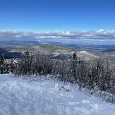
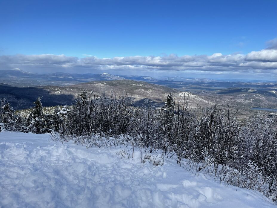
View from Mt Shaw of the White Mtns