
– Lat/Long: 42.86° N 72.11° W
 Mount Monadnock
Weather Forecast, United StatesIssued: 7 pm Sun 02 Aug Local TimeUpdates in: hr min sUpdate imminent
Issued: 7 pm Sun 02 Aug Local Time
Updates in:
Update imminent hr min s

Issued: 7 pm Sun 02 Aug Local Time
Updates in:
Update imminent hr min s
Days 1–4 Weather SummaryHeavy rain (total 21mm), heaviest during Mon afternoon. Warm (max 21°C on Tue afternoon, min 13°C on Mon night). Winds decreasing (strong winds from the NW on Mon night, light winds from the SW by Tue night). | Days 5–7 Weather SummaryLight rain (total 6mm), mostly falling on Fri night. Warm (max 25°C on Fri afternoon, min 18°C on Wed night). Mainly fresh winds. | ||||||||||||||||||
Monday 3 | Tuesday 4 | Wednesday 5 | Thursday 6 | Friday 7 | Saturday 8 | ||||||||||||||
night | AM | PM | night | AM | PM | night | AM | PM | night | AM | PM | night | AM | PM | night | AM | PM | night | |
light rain | mod. rain | risk tstorm | rain shwrs | clear | clear | some clouds | cloudy | light rain | rain shwrs | clear | rain shwrs | risk tstorm | clear | rain shwrs | risk tstorm | clear | some clouds | clear | |
Cloud base (m) | 500 | 250 | 300 | 8850 | 9400 | 900 | 300 | 300 | 5100 | 1600 | 2450 | 650 | 9250 | 2550 | 8800 | ||||
km/h | |||||||||||||||||||
 |  |  |  |  |  |  | |||||||||||||
— | — | — | — | — | — | — | — | — | — | — | — | — | — | — | — | — | — | — | |
mm | 0.9 | 5 | 11 | 0.2 | — | — | — | — | 3 | 1.1 | — | 0.4 | 1.1 | — | 0.3 | 3 | — | — | — |
max °C | 18 | 18 | 19 | 16 | 18 | 21 | 19 | 20 | 18 | 19 | 22 | 24 | 22 | 22 | 25 | 21 | 21 | 23 | 21 |
min °C | 17 | 18 | 17 | 13 | 16 | 21 | 17 | 18 | 18 | 18 | 19 | 23 | 20 | 21 | 24 | 18 | 18 | 23 | 19 |
chill °C | 16 | 17 | 15 | 10 | 14 | 21 | 17 | 18 | 18 | 18 | 19 | 23 | 20 | 21 | 24 | 17 | 18 | 23 | 19 |
Freezing level m | 4600 | 4550 | 4450 | 4350 | 4700 | 4850 | 4950 | 4650 | 4900 | 4850 | 4750 | 4900 | 4850 | 4700 | 4450 | 4500 | 4400 | 4400 | 4450 |
— | 5:41 | — | — | 5:41 | — | — | 5:43 | — | — | 5:43 | — | — | 5:45 | — | — | 5:46 | — | — | |
— | — | — | 8:07 | — | — | 8:06 | — | — | 8:04 | — | — | 8:02 | — | — | 8:01 | — | — | 8:00 | |
Loading...
Mount Monadnock Weather (Days 0-3):
The weather forecast for Mount Monadnock is: Heavy rain (total 21mm), heaviest during Mon afternoon. Warm (max 21°C on Tue afternoon, min 13°C on Mon night). Winds decreasing (strong winds from the NW on Mon night, light winds from the SW by Tue night).
Mount Monadnock Weather (Days 3-6):
Light rain (total 6mm), mostly falling on Fri night. Warm (max 25°C on Fri afternoon, min 18°C on Wed night). Mainly fresh winds.
This table gives the weather forecast for Mount Monadnock at the specific elevation of 965 m. Our advanced weather models allow us to provide distinct weather forecasts for several elevations of Mount Monadnock. To see the weather forecasts for the other elevations, use the tab navigation above the table. For a wider overview of the weather, consult the Weather Map of New-Hampshire.
| Weather Station | Temp. | Weather | Wind | Gusts | Cloud / Visibility |
|---|---|---|---|---|---|
Jaffrey Airport | |||||
Keen / illant-Hopkins Airport | |||||
* NOTE: not all weather observatories update at the same frequency which is the reason why some locations may show data from stations that are further away than known closer ones.
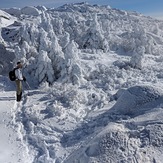
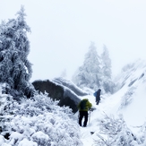
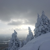
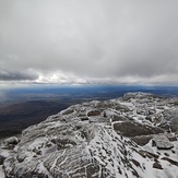
Mount Monadnock Photos
View all
New England Upland photos (25) |
Appalachians photos (910) |
photos from mountains in United States (3056) |
all photos
 Upload new photo


 See 22 more Mount Monadnock photos
Fog rainbow
Winter is coming
Mt. Monadnock Summit
Rap to TR the Billings Fold
Snow Mad
Winters back
Summit view