– Lat/Long: 40.95° S 175.28° E
 Mount Hector
Weather Forecast, New ZealandIssued: 11 pm Mon 03 Aug Local TimeUpdates in: hr min sUpdate imminent
Issued: 11 pm Mon 03 Aug Local Time
Updates in:
Update imminent hr min s

Issued: 11 pm Mon 03 Aug Local Time
Updates in:
Update imminent hr min s
Days 1–4 Weather SummaryA moderate fall of snow, heaviest on Tue morning. Freeze-thaw conditions (max 1°C on Mon night, min -7°C on Tue morning). Winds decreasing (severe gales from the SSW on Tue morning, light winds from the WSW by Thu afternoon). | Days 5–7 Weather SummaryA moderate fall of snow, heaviest on Sat morning. Turning milder with moderate rain (total 16mm), heaviest on Sat afternoon. Freeze-thaw conditions (max 3°C on Fri night, min -1°C on Sat night). Winds decreasing (severe gales from the WNW on Fri night, light winds from the W by Sat night). | |||||||||||||||
Tuesday 4 | Wednesday 5 | Thursday 6 | Friday 7 | Saturday 8 | ||||||||||||
night | AM | PM | night | AM | PM | night | AM | PM | night | AM | PM | night | AM | PM | night | |
light snow | snow shwrs | light snow | mod. snow | snow shwrs | snow shwrs | clear | clear | clear | clear | clear | cloudy | light snow | light snow | light snow | light snow | |
Cloud base (m) | 850 | 400 | 500 | 450 | 450 | 450 | 450 | 500 | 700 | 500 | 600 | 550 | 400 | 600 | 400 | 400 |
km/h | ||||||||||||||||
 |  |  |  |  |  | |||||||||||
2 | 4 | 2 | 7 | 2 | 1 | — | — | — | — | — | — | 1 | 5 | 3 | 3 | |
mm | — | — | — | — | — | — | — | — | — | — | — | — | 4 | 3 | 9 | — |
max °C | 1 | -7 | -7 | -6 | -6 | -4 | -3 | -2 | 0 | 1 | 1 | 1 | 3 | 2 | 2 | 1 |
min °C | -5 | -7 | -7 | -7 | -6 | -5 | -4 | -3 | -2 | 0 | 0 | 0 | 2 | 2 | 2 | -1 |
chill °C | -15 | -20 | -19 | -19 | -16 | -13 | -11 | -9 | -7 | -4 | -8 | -9 | -6 | -5 | -6 | -8 |
Freezing level m | 1450 | 600 | 600 | 600 | 650 | 900 | 0 | 950 | 1300 | 1700 | 1700 | 1600 | 2000 | 1900 | 1850 | 1600 |
— | 7:22 | — | — | 7:22 | — | — | 7:20 | — | — | 7:20 | — | — | 7:18 | — | — | |
— | — | 5:25 | — | — | 5:27 | — | — | 5:28 | — | — | 5:29 | — | — | 5:30 | — | |
Loading...
Mount Hector Weather (Days 0-3):
The weather forecast for Mount Hector is: A moderate fall of snow, heaviest on Tue morning. Freeze-thaw conditions (max 1°C on Mon night, min -7°C on Tue morning). Winds decreasing (severe gales from the SSW on Tue morning, light winds from the WSW by Thu afternoon).
Mount Hector Weather (Days 3-6):
A moderate fall of snow, heaviest on Sat morning. Turning milder with moderate rain (total 16mm), heaviest on Sat afternoon. Freeze-thaw conditions (max 3°C on Fri night, min -1°C on Sat night). Winds decreasing (severe gales from the WNW on Fri night, light winds from the W by Sat night).
This table gives the weather forecast for Mount Hector at the specific elevation of 1529 m. Our advanced weather models allow us to provide distinct weather forecasts for several elevations of Mount Hector. To see the weather forecasts for the other elevations, use the tab navigation above the table. For a wider overview of the weather, consult the Weather Map of New Zealand.
| Weather Station | Temp. | Weather | Wind | Gusts | Cloud / Visibility |
|---|---|---|---|---|---|
Te Horo | |||||
Settlement Road | |||||
Birchville- Upper Hutt |
* NOTE: not all weather observatories update at the same frequency which is the reason why some locations may show data from stations that are further away than known closer ones.
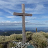
Mount Hector Photos
View all
Tararuas photos (7) |
New Zealand photos (156) |
photos from mountains in New Zealand (160) |
all photos
 Upload new photo
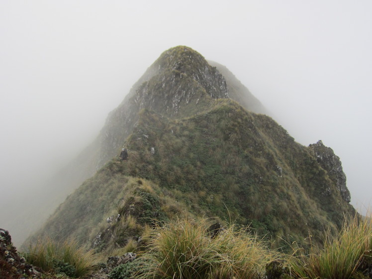
Heading to Hector on Neil Winchcombe Ridge
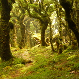
Mosst track
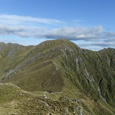
The track to Mt Hector
Memorial Cross