
– Lat/Long: 27.99° N 86.93° E
 Mount Everest
Weather Forecast, NepalIssued: 10 pm Mon 20 Jul Local TimeUpdates in: hr min sUpdate imminent
Issued: 10 pm Mon 20 Jul Local Time
Updates in:
Update imminent hr min s

Issued: 10 pm Mon 20 Jul Local Time
Updates in:
Update imminent hr min s
Days 1–4 Weather SummaryA heavy fall of snow, heaviest during Wed night. Extremely cold (max -18°C on Mon night, min -20°C on Mon night). Wind will be generally light. | Days 5–7 Weather SummaryA light covering of new snow mostly falling on Fri afternoon. Extremely cold (max -16°C on Sat night, min -18°C on Thu night). Wind will be generally light. | ||||||||||||||||||
Tuesday 21 | Wednesday 22 | Thursday 23 | Friday 24 | Saturday 25 | Sunday 26 | ||||||||||||||
night | AM | PM | night | AM | PM | night | AM | PM | night | AM | PM | night | AM | PM | night | AM | PM | night | |
snow shwrs | some clouds | snow shwrs | snow shwrs | light snow | snow shwrs | mod. snow | snow shwrs | snow shwrs | some clouds | some clouds | snow shwrs | some clouds | some clouds | snow shwrs | some clouds | some clouds | light snow | snow shwrs | |
Cloud base (m) | 6250 | 6250 | 6350 | 6250 | 6250 | 6250 | 6250 | 6250 | 6250 | 6200 | 6300 | 6250 | 6250 | 6350 | 6300 | 6250 | 6300 | 6250 | 6250 |
km/h | |||||||||||||||||||
 |  |  |  |  |  |  | |||||||||||||
5 | — | 2 | 5 | 2 | 4 | 9 | 2 | 2 | — | — | 3 | — | — | 2 | — | — | 2 | 2 | |
mm | — | — | — | — | — | — | — | — | — | — | — | — | — | — | — | — | — | — | — |
max °C | -18 | -19 | -18 | -18 | -19 | -18 | -18 | -19 | -18 | -17 | -18 | -17 | -17 | -17 | -17 | -16 | -17 | -17 | -16 |
min °C | -20 | -20 | -19 | -19 | -19 | -18 | -19 | -19 | -18 | -18 | -18 | -18 | -18 | -18 | -17 | -17 | -17 | -17 | -17 |
chill °C | -32 | -31 | -30 | -24 | -19 | -18 | -25 | -24 | -23 | -23 | -18 | -24 | -18 | -23 | -23 | -17 | -17 | -23 | -23 |
Freezing level m | 5700 | 5900 | 5850 | 5650 | 5850 | 5900 | 5700 | 5900 | 5950 | 5800 | 6000 | 6050 | 5850 | 6100 | 6100 | 6000 | 6100 | 6100 | 6050 |
— | 5:13 | — | — | 5:13 | — | — | 5:13 | — | — | 5:15 | — | — | 5:15 | — | — | 5:16 | — | — | |
— | — | 6:52 | — | — | 6:52 | — | — | 6:52 | — | — | 6:52 | — | — | 6:51 | — | — | 6:51 | — | |
Loading...
Mount Everest Weather (Days 0-3):
The weather forecast for Mount Everest is: A heavy fall of snow, heaviest during Wed night. Extremely cold (max -18°C on Mon night, min -20°C on Mon night). Wind will be generally light.
Mount Everest Weather (Days 3-6):
A light covering of new snow mostly falling on Fri afternoon. Extremely cold (max -16°C on Sat night, min -18°C on Thu night). Wind will be generally light.
This table gives the weather forecast for Mount Everest at the specific elevation of 8850 m. Our advanced weather models allow us to provide distinct weather forecasts for several elevations of Mount Everest. To see the weather forecasts for the other elevations, use the tab navigation above the table. For a wider overview of the weather, consult the Weather Map of Nepal.
| Weather Station | Temp. | Weather | Wind | Gusts | Cloud / Visibility |
|---|---|---|---|---|---|
Tingri | |||||
Baghdogra (in-af | |||||
* NOTE: not all weather observatories update at the same frequency which is the reason why some locations may show data from stations that are further away than known closer ones.
Mount Everest Photos
View all
Central Nepal Himalaya photos (210) |
Greater Himalaya photos (383) |
photos from mountains in Nepal (296) |
all photos
 Upload new photo
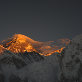

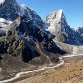
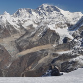 See 57 more Mount Everest photos
ALTITUDE JUNKIES -EVEREST
Sunrise from the summit of Everest
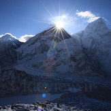
Kalla Pattar
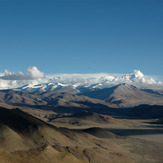
Mount Everest and Cho Oyu from Tingri
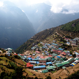
Namche Bazar
Nepal
Everest and Lhotse from Mera Peak