
– Lat/Long: 50.76° N 115.10° W
 Mount Evan-Thomas
Weather Forecast, CanadaIssued: 11 pm Sun 02 Aug Local TimeUpdates in: hr min sUpdate imminent
Issued: 11 pm Sun 02 Aug Local Time
Updates in:
Update imminent hr min s

Issued: 11 pm Sun 02 Aug Local Time
Updates in:
Update imminent hr min s
Days 1–4 Weather SummaryA dusting of new snow. Freeze-thaw conditions (max 10°C on Wed afternoon, min -4°C on Sun night). Wind will be generally light. | Days 5–7 Weather SummaryLight rain (total 3mm), mostly falling on Sat afternoon. Very mild (max 11°C on Thu afternoon, min 3°C on Sat morning). Winds increasing (calm on Wed night, strong winds from the W by Fri afternoon). | ||||||||||||||||||
Monday 3 | Tuesday 4 | Wednesday 5 | Thursday 6 | Friday 7 | Saturday 8 | ||||||||||||||
night | AM | PM | night | AM | PM | night | AM | PM | night | AM | PM | night | AM | PM | night | AM | PM | night | |
light snow | some clouds | cloudy | clear | some clouds | some clouds | some clouds | clear | clear | clear | some clouds | some clouds | rain shwrs | clear | some clouds | clear | rain shwrs | rain shwrs | mod. rain | |
Cloud base (m) | 2550 | 2250 | 3100 | 3050 | 6650 | 4500 | 6200 | 5950 | 8850 | 7050 | 2800 | 2400 | 2700 | 2250 | |||||
km/h | |||||||||||||||||||
 |  |  |  |  |  |  | |||||||||||||
2 | — | — | — | — | — | — | — | — | — | — | — | — | — | — | — | — | — | — | |
mm | — | — | — | — | — | — | — | — | — | — | — | — | 0.1 | — | — | — | 0.1 | 3 | 6 |
max °C | 0 | -2 | 0 | 1 | 2 | 6 | 6 | 7 | 10 | 10 | 9 | 11 | 11 | 11 | 11 | 9 | 4 | 4 | 3 |
min °C | -4 | -3 | 0 | 0 | 1 | 5 | 5 | 5 | 9 | 7 | 8 | 11 | 8 | 10 | 11 | 5 | 3 | 3 | 3 |
chill °C | -9 | -7 | -2 | -2 | -2 | 3 | 3 | 3 | 7 | 4 | 5 | 8 | 6 | 7 | 8 | 3 | 1 | 1 | -1 |
Freezing level m | 2900 | 2600 | 3150 | 3250 | 3250 | 3850 | 4000 | 3950 | 4450 | 4500 | 4250 | 4500 | 4550 | 4550 | 4550 | 4100 | 3700 | 3700 | 3550 |
— | 6:09 | — | — | 6:09 | — | — | 6:11 | — | — | 6:13 | — | — | 6:15 | — | — | 6:16 | — | — | |
— | — | — | 9:22 | — | — | 9:21 | — | — | 9:19 | — | — | 9:16 | — | — | 9:15 | — | — | 9:14 | |
Loading...
Mount Evan-Thomas Weather (Days 0-3):
The weather forecast for Mount Evan-Thomas is: A dusting of new snow. Freeze-thaw conditions (max 10°C on Wed afternoon, min -4°C on Sun night). Wind will be generally light.
Mount Evan-Thomas Weather (Days 3-6):
Light rain (total 3mm), mostly falling on Sat afternoon. Very mild (max 11°C on Thu afternoon, min 3°C on Sat morning). Winds increasing (calm on Wed night, strong winds from the W by Fri afternoon).
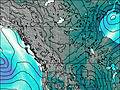
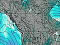
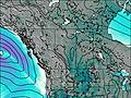
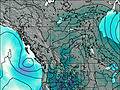
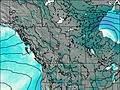
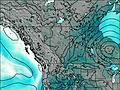
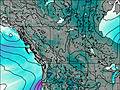
This table gives the weather forecast for Mount Evan-Thomas at the specific elevation of 3098 m. Our advanced weather models allow us to provide distinct weather forecasts for several elevations of Mount Evan-Thomas. To see the weather forecasts for the other elevations, use the tab navigation above the table. For a wider overview of the weather, consult the Weather Map of Alberta.
| Weather Station | Temp. | Weather | Wind | Gusts | Cloud / Visibility |
|---|---|---|---|---|---|
Banff Airport | |||||
Swansea Mtn | |||||
Black Diamond- Alta | |||||
Cop Upper- Alta |
* NOTE: not all weather observatories update at the same frequency which is the reason why some locations may show data from stations that are further away than known closer ones.