Mount Cokely Climbing Notes

Mount Cokely climbing notes shared by Mountain-Forecast users
Click here to submit your own climbing note for Mount Cokely
(NOTE: Texts may be edited by our content team for the purposes of ensuring accurate and relevant information)
-
February 12, 2014
Evan from Canada
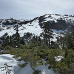
We hiked to the summit of Mt Cokely on Feb 10th 2014, the first day of a two day snow storm with significant wind coming from the west. There had been a few inches of snow already fallen on a layer of frozen melt that covered everything.
We used the east part of the CPR Trail loop from Cameron Lake to get up to the old ski area. The CPR trail was in great shape, with a 2-5 cm of snow dusting. Frozen melt water on the trail made micro-spikes really nice to have. The trail is quite well marked until up in the alpine area where the snow makes it tough to tell where to go.
Once we got up around the tree line the wind picked up a lot as the old ski area is quite exposed. Climbing to the summit this way is called the North Slopes route. There really isn't anything technical this way. Most of the slope angle is less than 20 degrees except for the last 100-150 metres, which is between 35-45 degrees. With the icy, windswept conditions, switching to crampons was a good idea; the micro-spikes didn't dig in enough. Hiking poles worked better than an ice axe here too, it's just not steep enough to need the axe.
The last 100-150 metre stretch is steep enough to be worrisome for avalanches under certain conditions. You can easily tell where this part is, as the last section of the mountain rears up in front of you and the communications building on the top seems close. This last slope is a prime avalanche angle, so if there is enough snow, and the snow has been showing signs of instability on the way up, turn around before nearing the bottom of this last part.
The two of us that did this hike are used to doing long, hard day hikes, and it took us 4.5 hours to reach the summit and 2.5 hours back down to the car.
(NOTE: Texts may be edited by our content team for the purposes of ensuring accurate and relevant information)
Evan from Canada
We hiked to the summit of Mt Cokely on Feb 10th 2014, the first day of a two day snow storm with significant wind coming from the west. There had been a few inches of snow already fallen on a layer of frozen melt that covered everything.
We used the east part of the CPR Trail loop from Cameron Lake to get up to the old ski area. The CPR trail was in great shape, with a 2-5 cm of snow dusting. Frozen melt water on the trail made micro-spikes really nice to have. The trail is quite well marked until up in the alpine area where the snow makes it tough to tell where to go.
Once we got up around the tree line the wind picked up a lot as the old ski area is quite exposed. Climbing to the summit this way is called the North Slopes route. There really isn't anything technical this way. Most of the slope angle is less than 20 degrees except for the last 100-150 metres, which is between 35-45 degrees. With the icy, windswept conditions, switching to crampons was a good idea; the micro-spikes didn't dig in enough. Hiking poles worked better than an ice axe here too, it's just not steep enough to need the axe.
The last 100-150 metre stretch is steep enough to be worrisome for avalanches under certain conditions. You can easily tell where this part is, as the last section of the mountain rears up in front of you and the communications building on the top seems close. This last slope is a prime avalanche angle, so if there is enough snow, and the snow has been showing signs of instability on the way up, turn around before nearing the bottom of this last part.
The two of us that did this hike are used to doing long, hard day hikes, and it took us 4.5 hours to reach the summit and 2.5 hours back down to the car.