– Lat/Long: 37.73° N 15.00° E
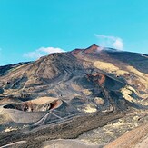
 Monte Etna
Weather Forecast, ItalyIssued: 7 am Mon 03 Aug Local TimeUpdates in: hr min sUpdate imminent
Issued: 7 am Mon 03 Aug Local Time
Updates in:
Update imminent hr min s

Issued: 7 am Mon 03 Aug Local Time
Updates in:
Update imminent hr min s
Days 1–3 Weather SummaryLight rain (total 2mm), mostly falling on Mon afternoon. Mild temperatures (max 9°C on Tue night, min 6°C on Mon afternoon). Wind will be generally light. | Days 4–6 Weather SummaryMostly dry. Mild temperatures (max 9°C on Sat afternoon, min 6°C on Thu afternoon). Wind will be generally light. | |||||||||||||||||
Monday 3 | Tuesday 4 | Wednesday 5 | Thursday 6 | Friday 7 | Saturday 8 | |||||||||||||
AM | PM | night | AM | PM | night | AM | PM | night | AM | PM | night | AM | PM | night | AM | PM | night | |
clear | risk tstorm | risk tstorm | clear | some clouds | clear | clear | some clouds | some clouds | rain shwrs | light rain | clear | clear | some clouds | clear | clear | some clouds | clear | |
Cloud base (m) | 2650 | 4550 | 4800 | 4350 | 3000 | |||||||||||||
km/h | ||||||||||||||||||
 |  |  |  |  |  | |||||||||||||
— | — | — | — | — | — | — | — | — | — | — | — | — | — | — | — | — | — | |
mm | — | 2 | 0.3 | — | — | — | — | — | — | 0.1 | 0.1 | — | — | — | — | — | — | — |
max °C | 7 | 7 | 7 | 7 | 8 | 9 | 8 | 9 | 8 | 7 | 7 | 8 | 7 | 8 | 8 | 8 | 9 | 9 |
min °C | 7 | 6 | 7 | 7 | 7 | 8 | 8 | 9 | 8 | 7 | 6 | 7 | 7 | 7 | 8 | 8 | 9 | 8 |
chill °C | 5 | 2 | 3 | 4 | 4 | 5 | 5 | 6 | 6 | 6 | 5 | 5 | 5 | 4 | 6 | 6 | 8 | 8 |
Freezing level m | 4350 | 4300 | 4350 | 4400 | 4550 | 4600 | 4550 | 4550 | 4450 | 4500 | 4500 | 4650 | 4500 | 4450 | 4600 | 4600 | 4700 | 4750 |
6:03 | — | — | 6:05 | — | — | 6:05 | — | — | 6:07 | — | — | 6:07 | — | — | 6:07 | — | — | |
— | — | 8:07 | — | — | 8:06 | — | — | 8:05 | — | — | 8:04 | — | — | 8:02 | — | — | 8:00 | |
Loading...
Monte Etna Weather (Days 0-3):
The weather forecast for Monte Etna is: Light rain (total 2mm), mostly falling on Mon afternoon. Mild temperatures (max 9°C on Tue night, min 6°C on Mon afternoon). Wind will be generally light.
Monte Etna Weather (Days 3-6):
Mostly dry. Mild temperatures (max 9°C on Sat afternoon, min 6°C on Thu afternoon). Wind will be generally light.
This table gives the weather forecast for Monte Etna at the specific elevation of 3323 m. Our advanced weather models allow us to provide distinct weather forecasts for several elevations of Monte Etna. To see the weather forecasts for the other elevations, use the tab navigation above the table. For a wider overview of the weather, consult the Weather Map of Italy.
| Weather Station | Temp. | Weather | Wind | Gusts | Cloud / Visibility |
|---|---|---|---|---|---|
Catania Fontanarossa | |||||
BIG FISH NORTE BF28 | |||||
SARDELLA | |||||
BIG FISH SUR 07 | |||||
Catania Sigonella | |||||
Sigonella Airport | |||||
Reggio Calabria |
* NOTE: not all weather observatories update at the same frequency which is the reason why some locations may show data from stations that are further away than known closer ones.
Monte Etna Photos
View all
Sicily photos (10) |
Italian Peninsula and Islands photos (160) |
photos from mountains in Italy (430) |
all photos
 Upload new photo
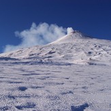

 See 8 more Monte Etna photos
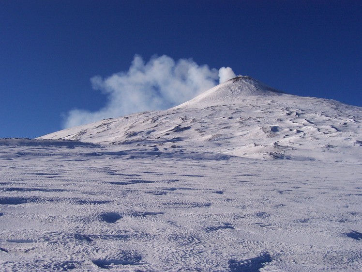
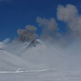
Etna summit in winter
Monte Etna
Mount Etna Behind the Cityscape of Catania, Sicily
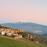
Mount Etna Viewed from Gagliano Castelferrato at Sunset
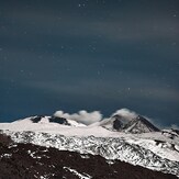
Mount Etna Under a Star-Filled Sky
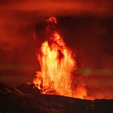
Eruption of Mount Etna Lighting the Night Sky
Crater Landscape on the Slopes of Mount Etna