– Lat/Long: 45.57° N 71.68° W
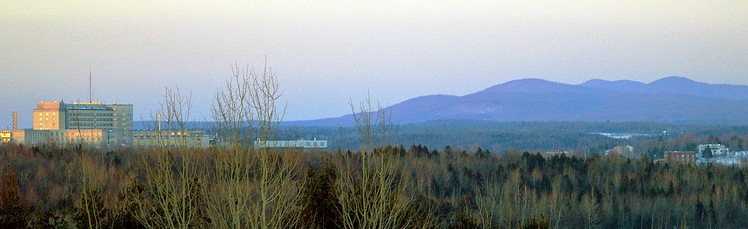
 Mont Chapman
Weather Forecast, CanadaIssued: 7 am Mon 03 Aug Local TimeUpdates in: hr min sUpdate imminent
Issued: 7 am Mon 03 Aug Local Time
Updates in:
Update imminent hr min s

Issued: 7 am Mon 03 Aug Local Time
Updates in:
Update imminent hr min s
Days 1–3 Weather SummaryModerate rain (total 13mm), heaviest on Mon afternoon. Warm (max 25°C on Wed afternoon, min 12°C on Mon night). Winds decreasing (strong winds from the WNW on Mon night, calm by Tue night). | Days 4–6 Weather SummaryLight rain (total 4mm), mostly falling on Fri night. Warm (max 26°C on Thu afternoon, min 18°C on Fri night). Wind will be generally light. | |||||||||||||||||
Monday 3 | Tuesday 4 | Wednesday 5 | Thursday 6 | Friday 7 | Saturday 8 | |||||||||||||
AM | PM | night | AM | PM | night | AM | PM | night | AM | PM | night | AM | PM | night | AM | PM | night | |
light rain | mod. rain | rain shwrs | clear | clear | clear | clear | clear | clear | clear | some clouds | some clouds | risk tstorm | risk tstorm | risk tstorm | clear | clear | clear | |
Cloud base (m) | 250 | 600 | 650 | 9000 | 9800 | 2350 | 2600 | 500 | 6250 | 300 | 300 | |||||||
km/h | ||||||||||||||||||
 |  |  |  |  |  | |||||||||||||
— | — | — | — | — | — | — | — | — | — | — | — | — | — | — | — | — | — | |
mm | 4 | 7 | 2 | — | — | — | — | — | — | — | — | — | 0.3 | 0.1 | 4 | — | — | — |
max °C | 19 | 20 | 14 | 18 | 21 | 19 | 22 | 25 | 21 | 23 | 26 | 23 | 22 | 24 | 21 | 23 | 25 | 22 |
min °C | 18 | 18 | 12 | 15 | 20 | 16 | 18 | 24 | 17 | 19 | 25 | 19 | 20 | 24 | 18 | 19 | 25 | 19 |
chill °C | 17 | 17 | 9 | 13 | 20 | 16 | 18 | 24 | 17 | 19 | 25 | 19 | 20 | 24 | 18 | 19 | 25 | 19 |
Freezing level m | 4450 | 4150 | 2850 | 4500 | 4450 | 4750 | 4650 | 4750 | 4700 | 4550 | 4500 | 4500 | 4550 | 4400 | 4350 | 4200 | 4250 | 4300 |
5:31 | — | — | 5:33 | — | — | 5:33 | — | — | 5:35 | — | — | 5:35 | — | — | 5:37 | — | — | |
— | — | 8:12 | — | — | 8:10 | — | — | 8:09 | — | — | 8:07 | — | — | 8:07 | — | — | 8:05 | |
Loading...
Mont Chapman Weather (Days 0-3):
The weather forecast for Mont Chapman is: Moderate rain (total 13mm), heaviest on Mon afternoon. Warm (max 25°C on Wed afternoon, min 12°C on Mon night). Winds decreasing (strong winds from the WNW on Mon night, calm by Tue night).
Mont Chapman Weather (Days 3-6):
Light rain (total 4mm), mostly falling on Fri night. Warm (max 26°C on Thu afternoon, min 18°C on Fri night). Wind will be generally light.
This table gives the weather forecast for Mont Chapman at the specific elevation of 658 m. Our advanced weather models allow us to provide distinct weather forecasts for several elevations of Mont Chapman. To see the weather forecasts for the other elevations, use the tab navigation above the table. For a wider overview of the weather, consult the Weather Map of Quebec.
| Weather Station | Temp. | Weather | Wind | Gusts | Cloud / Visibility |
|---|---|---|---|---|---|
Sherbrooke- Que | |||||
lightning 12km NE of Windsor | |||||
Lennoxville- Que | |||||
lightning 12km WNW of Sherbrooke | |||||
lightning 8km WSW of Valcourt | |||||
thunderstorm affecting Waterloo |
* NOTE: not all weather observatories update at the same frequency which is the reason why some locations may show data from stations that are further away than known closer ones.
Mont Chapman Photos
View all
Pilot Range photos (2) |
Appalachians photos (910) |
photos from mountains in Canada (457) |
all photos
 Upload new photo
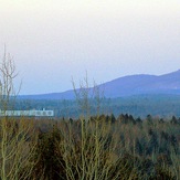
Mont Chapman