– Lat/Long: 48.45° N 121.06° W
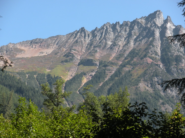
 Mix-up Peak
Weather Forecast, United StatesIssued: 4 am Mon 03 Aug Local TimeUpdates in: hr min sUpdate imminent
Issued: 4 am Mon 03 Aug Local Time
Updates in:
Update imminent hr min s

Issued: 4 am Mon 03 Aug Local Time
Updates in:
Update imminent hr min s
Days 1–3 Weather SummaryMostly dry. Warm (max 31°C on Wed afternoon, min 15°C on Mon morning). Wind will be generally light. | Days 4–6 Weather SummaryMostly dry. Warm (max 31°C on Thu afternoon, min 14°C on Fri night). Wind will be generally light. | |||||||||||||||||
Monday 3 | Tuesday 4 | Wednesday 5 | Thursday 6 | Friday 7 | Saturday 8 | |||||||||||||
AM | PM | night | AM | PM | night | AM | PM | night | AM | PM | night | AM | PM | night | AM | PM | night | |
clear | clear | clear | clear | clear | clear | clear | clear | clear | clear | clear | clear | clear | clear | clear | clear | clear | clear | |
Cloud base (m) | 8600 | 6750 | 8450 | 8500 | ||||||||||||||
km/h | ||||||||||||||||||
 |  |  |  |  |  | |||||||||||||
— | — | — | — | — | — | — | — | — | — | — | — | — | — | — | — | — | — | |
mm | — | — | — | — | — | — | — | — | — | — | — | — | — | — | — | — | — | — |
max °C | 21 | 26 | 22 | 26 | 29 | 24 | 28 | 31 | 25 | 28 | 31 | 25 | 24 | 26 | 20 | 22 | 25 | 20 |
min °C | 15 | 24 | 16 | 21 | 28 | 18 | 23 | 31 | 19 | 23 | 31 | 17 | 19 | 25 | 14 | 18 | 25 | 15 |
chill °C | 15 | 24 | 16 | 21 | 28 | 18 | 23 | 31 | 19 | 23 | 31 | 17 | 19 | 25 | 14 | 18 | 25 | 15 |
Freezing level m | 3150 | 3550 | 3600 | 3700 | 4100 | 4350 | 4450 | 4550 | 4800 | 4650 | 4550 | 4300 | 4000 | 3950 | 4150 | 4050 | 4100 | 4150 |
5:41 | — | — | 5:41 | — | — | 5:43 | — | — | 5:45 | — | — | 5:46 | — | — | 5:47 | — | — | |
— | — | 8:37 | — | — | 8:37 | — | — | 8:35 | — | — | 8:34 | — | — | 8:31 | — | — | 8:30 | |
Loading...
Mix-up Peak Weather (Days 0-3):
The weather forecast for Mix-up Peak is: Mostly dry. Warm (max 31°C on Wed afternoon, min 15°C on Mon morning). Wind will be generally light.
Mix-up Peak Weather (Days 3-6):
Mostly dry. Warm (max 31°C on Thu afternoon, min 14°C on Fri night). Wind will be generally light.
This table gives the weather forecast for Mix-up Peak at the specific elevation of 500 m. Our advanced weather models allow us to provide distinct weather forecasts for several elevations of Mix-up Peak. To see the weather forecasts for the other elevations, use the tab navigation above the table. For a wider overview of the weather, consult the Weather Map of Washington.
| Weather Station | Temp. | Weather | Wind | Gusts | Cloud / Visibility |
|---|---|---|---|---|---|
Winthrop Airport (Washington) | |||||
Agassiz Airport | |||||
BUOY-PBFW1 | |||||
Hope Airport | |||||
SHIP6847 | |||||
SHIP7436 | |||||
SHIP8183 |
* NOTE: not all weather observatories update at the same frequency which is the reason why some locations may show data from stations that are further away than known closer ones.
Mix-up Peak Photos
View all
Cascade Range photos (451) |
Pacific Coast Ranges photos (1060) |
photos from mountains in United States (3056) |
all photos
 Upload new photo
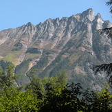
South side of Mix Up Peak