– Lat/Long: 27.70° N 86.87° E
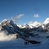
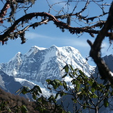
 Mera Peak
Weather Forecast, NepalIssued: 10 pm Sun 02 Aug Local TimeUpdates in: hr min sUpdate imminent
Issued: 10 pm Sun 02 Aug Local Time
Updates in:
Update imminent hr min s

Issued: 10 pm Sun 02 Aug Local Time
Updates in:
Update imminent hr min s
Days 1–4 Weather SummaryA heavy fall of snow, heaviest during Mon afternoon. Temperatures will be below freezing (max -3°C on Sun night, min -4°C on Sun night). Wind will be generally light. | Days 5–7 Weather SummaryA light covering of new snow mostly falling on Wed night. Temperatures will be below freezing (max -2°C on Sat afternoon, min -4°C on Wed night). Wind will be generally light. | ||||||||||||||||||
Monday 3 | Tuesday 4 | Wednesday 5 | Thursday 6 | Friday 7 | Saturday 8 | ||||||||||||||
night | AM | PM | night | AM | PM | night | AM | PM | night | AM | PM | night | AM | PM | night | AM | PM | night | |
snow shwrs | snow shwrs | snow shwrs | snow shwrs | snow shwrs | light snow | snow shwrs | snow shwrs | light snow | snow shwrs | light snow | light snow | some clouds | some clouds | snow shwrs | some clouds | some clouds | snow shwrs | some clouds | |
Cloud base (m) | 4850 | 4950 | 5050 | 5050 | 4950 | 5000 | 4900 | 5100 | 4850 | 4900 | 5100 | 4850 | 5150 | 5400 | 5050 | 5150 | 5050 | 5200 | |
km/h | |||||||||||||||||||
 |  |  |  |  |  |  | |||||||||||||
2 | 1 | 4 | 5 | 3 | 2 | 3 | 2 | 2 | 2 | 1 | 2 | — | — | 1 | — | — | 2 | — | |
mm | — | — | — | — | — | — | — | — | — | — | — | — | — | — | — | — | — | — | — |
max °C | -3 | -3 | -3 | -3 | -3 | -3 | -3 | -3 | -3 | -3 | -4 | -3 | -3 | -4 | -3 | -3 | -3 | -2 | -3 |
min °C | -4 | -4 | -3 | -4 | -3 | -3 | -4 | -4 | -3 | -4 | -4 | -3 | -4 | -4 | -3 | -4 | -3 | -3 | -3 |
chill °C | -7 | -6 | -5 | -8 | -5 | -6 | -4 | -7 | -3 | -7 | -6 | -7 | -10 | -10 | -8 | -9 | -6 | -3 | -5 |
Freezing level m | 5750 | 5900 | 5950 | 5850 | 5950 | 6000 | 5800 | 5900 | 5950 | 5800 | 5850 | 5950 | 5750 | 5850 | 6000 | 5850 | 6000 | 6050 | 5900 |
— | 5:20 | — | — | 5:22 | — | — | 5:22 | — | — | 5:22 | — | — | 5:22 | — | — | 5:24 | — | — | |
— | — | 6:45 | — | — | 6:44 | — | — | 6:44 | — | — | 6:43 | — | — | 6:42 | — | — | 6:40 | — | |
Loading...
Mera Peak Weather (Days 0-3):
The weather forecast for Mera Peak is: A heavy fall of snow, heaviest during Mon afternoon. Temperatures will be below freezing (max -3°C on Sun night, min -4°C on Sun night). Wind will be generally light.
Mera Peak Weather (Days 3-6):
A light covering of new snow mostly falling on Wed night. Temperatures will be below freezing (max -2°C on Sat afternoon, min -4°C on Wed night). Wind will be generally light.
This table gives the weather forecast for Mera Peak at the specific elevation of 6476 m. Our advanced weather models allow us to provide distinct weather forecasts for several elevations of Mera Peak. To see the weather forecasts for the other elevations, use the tab navigation above the table. For a wider overview of the weather, consult the Weather Map of Nepal.
| Weather Station | Temp. | Weather | Wind | Gusts | Cloud / Visibility |
|---|---|---|---|---|---|
Tingri | |||||
Baghdogra (in-af | |||||
* NOTE: not all weather observatories update at the same frequency which is the reason why some locations may show data from stations that are further away than known closer ones.
Mera Peak Photos
View all
Central Nepal Himalaya photos (211) |
Greater Himalaya photos (384) |
photos from mountains in Nepal (297) |
all photos
 Upload new photo
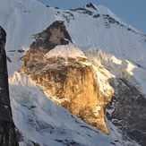

 See 27 more Mera Peak photos
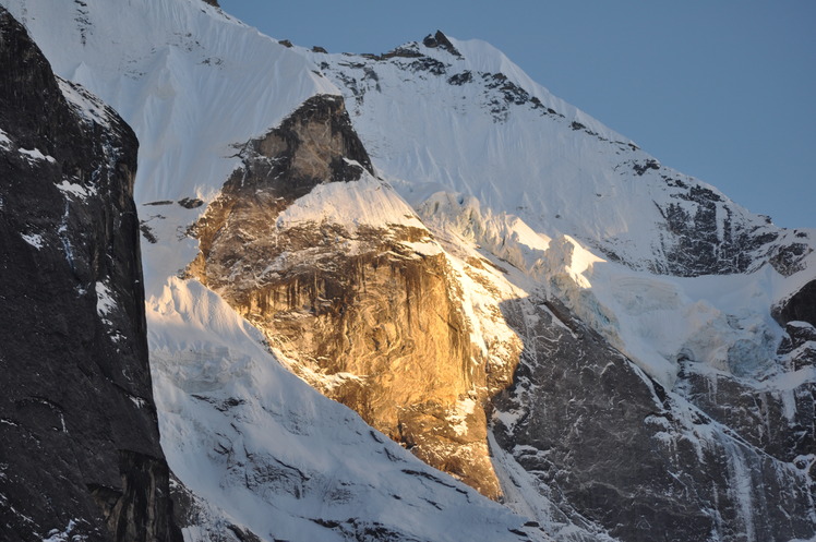
Khare Sunsetet
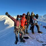
Mera Peak Summit
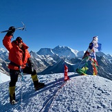
Mera Peak
Mera Peak -High Camp View
Alpinist Climber Expeditions - ACE
MERA SUMMIT RIDGE
Alpinist Climber Expeditions