
– Lat/Long: 19.20° S 57.60° W
 Maciço do Urucum (Macico do Urucum)
Weather Forecast, BrazilIssued: 7 am Mon 03 Aug Local TimeUpdates in: hr min sUpdate imminent
Issued: 7 am Mon 03 Aug Local Time
Updates in:
Update imminent hr min s

Issued: 7 am Mon 03 Aug Local Time
Updates in:
Update imminent hr min s
Days 1–3 Weather SummarySome drizzle, heaviest during Mon night. Warm (max 28°C on Wed afternoon, min 22°C on Mon morning). Winds decreasing (fresh winds from the NNE on Mon morning, light winds from the NW by Tue afternoon). | Days 4–6 Weather SummaryMostly dry. Warm (max 30°C on Thu afternoon, min 24°C on Fri night). Mainly gales. | |||||||||||||||||
Monday 3 | Tuesday 4 | Wednesday 5 | Thursday 6 | Friday 7 | Saturday 8 | |||||||||||||
AM | PM | night | AM | PM | night | AM | PM | night | AM | PM | night | AM | PM | night | AM | PM | night | |
cloudy | rain shwrs | rain shwrs | rain shwrs | risk tstorm | rain shwrs | clear | light rain | clear | clear | clear | clear | clear | clear | clear | clear | clear | clear | |
Cloud base (m) | 3700 | 6100 | 5400 | 3300 | 4100 | 3000 | ||||||||||||
km/h | ||||||||||||||||||
 |  |  |  |  |  | |||||||||||||
— | — | — | — | — | — | — | — | — | — | — | — | — | — | — | — | — | — | |
mm | — | 0.1 | 0.8 | 0.1 | 0.3 | 0.2 | — | 0.4 | — | — | — | — | — | — | — | — | — | — |
max °C | 24 | 25 | 23 | 24 | 27 | 24 | 26 | 28 | 26 | 28 | 30 | 29 | 26 | 26 | 24 | 28 | 30 | 29 |
min °C | 22 | 24 | 22 | 22 | 26 | 23 | 23 | 25 | 24 | 25 | 29 | 25 | 26 | 26 | 24 | 25 | 30 | 26 |
chill °C | 22 | 24 | 22 | 22 | 26 | 23 | 23 | 25 | 24 | 25 | 29 | 25 | 26 | 26 | 24 | 25 | 30 | 26 |
Freezing level m | 4200 | 4250 | 4250 | 4250 | 4250 | 4300 | 4250 | 4300 | 4400 | 4500 | 4750 | 4650 | 4600 | 4550 | 4700 | 4650 | 4850 | 4750 |
6:18 | — | — | 6:16 | — | — | 6:16 | — | — | 6:16 | — | — | 6:16 | — | — | 6:15 | — | — | |
— | 5:35 | — | — | 5:35 | — | — | 5:35 | — | — | 5:36 | — | — | 5:36 | — | — | 5:36 | — | |
Loading...
Maciço do Urucum Weather (Days 0-3):
The weather forecast for Maciço do Urucum is: Some drizzle, heaviest during Mon night. Warm (max 28°C on Wed afternoon, min 22°C on Mon morning). Winds decreasing (fresh winds from the NNE on Mon morning, light winds from the NW by Tue afternoon).
Maciço do Urucum Weather (Days 3-6):
Mostly dry. Warm (max 30°C on Thu afternoon, min 24°C on Fri night). Mainly gales.
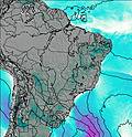
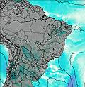
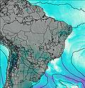
This table gives the weather forecast for Maciço do Urucum at the specific elevation of 1065 m. Our advanced weather models allow us to provide distinct weather forecasts for several elevations of Maciço do Urucum. To see the weather forecasts for the other elevations, use the tab navigation above the table. For a wider overview of the weather, consult the Weather Map of Brazil.
| Weather Station | Temp. | Weather | Wind | Gusts | Cloud / Visibility |
|---|---|---|---|---|---|
Puerto Suare / alvador Ogaya Airport | |||||
Nhumirim (86768 -0) | |||||
Miranda | |||||
Robore Airport | |||||
San Jose Airport | |||||
* NOTE: not all weather observatories update at the same frequency which is the reason why some locations may show data from stations that are further away than known closer ones.