
– Lat/Long: 43.40° N 72.72° W
 Ludlow Mountain
Weather Forecast, United StatesIssued: 7 am Mon 03 Aug Local TimeUpdates in: hr min sUpdate imminent
Issued: 7 am Mon 03 Aug Local Time
Updates in:
Update imminent hr min s

Issued: 7 am Mon 03 Aug Local Time
Updates in:
Update imminent hr min s
Days 1–3 Weather SummaryLight rain (total 8mm), mostly falling on Mon afternoon. Warm (max 22°C on Wed afternoon, min 13°C on Mon night). Winds decreasing (near gales from the NW on Mon night, calm by Tue night). | Days 4–6 Weather SummaryLight rain (total 8mm), mostly falling on Thu night. Warm (max 24°C on Thu afternoon, min 19°C on Fri night). Winds decreasing (fresh winds from the W on Thu night, calm by Sat night). | |||||||||||||||||
Monday 3 | Tuesday 4 | Wednesday 5 | Thursday 6 | Friday 7 | Saturday 8 | |||||||||||||
AM | PM | night | AM | PM | night | AM | PM | night | AM | PM | night | AM | PM | night | AM | PM | night | |
light rain | risk tstorm | rain shwrs | clear | clear | clear | some clouds | some clouds | some clouds | some clouds | rain shwrs | risk tstorm | some clouds | rain shwrs | risk tstorm | some clouds | clear | rain shwrs | |
Cloud base (m) | 350 | 450 | 6950 | 5150 | 6600 | 2400 | 4450 | 4950 | 5850 | 6100 | 6250 | 9200 | ||||||
km/h | ||||||||||||||||||
 |  |  |  |  |  | |||||||||||||
— | — | — | — | — | — | — | — | — | — | — | — | — | — | — | — | — | — | |
mm | 4 | 5 | 0.1 | — | — | — | — | — | — | — | 0.7 | 7 | — | 0.7 | 0.4 | — | — | 0.1 |
max °C | 18 | 18 | 14 | 17 | 20 | 19 | 20 | 22 | 20 | 21 | 24 | 20 | 21 | 23 | 21 | 21 | 22 | 21 |
min °C | 18 | 15 | 13 | 16 | 19 | 17 | 18 | 22 | 18 | 20 | 23 | 20 | 20 | 22 | 19 | 19 | 22 | 19 |
chill °C | 17 | 12 | 9 | 14 | 19 | 17 | 18 | 22 | 18 | 20 | 23 | 20 | 20 | 22 | 19 | 19 | 22 | 19 |
Freezing level m | 4550 | 4600 | 4300 | 4750 | 4900 | 4800 | 4800 | 5000 | 4700 | 4700 | 4700 | 4750 | 4600 | 4550 | 4550 | 4450 | 4550 | 4600 |
5:41 | — | — | 5:43 | — | — | 5:43 | — | — | 5:45 | — | — | 5:46 | — | — | 5:47 | — | — | |
— | — | 8:10 | — | — | 8:08 | — | — | 8:07 | — | — | 8:07 | — | — | 8:06 | — | — | 8:04 | |
Loading...
Ludlow Mountain Weather (Days 0-3):
The weather forecast for Ludlow Mountain is: Light rain (total 8mm), mostly falling on Mon afternoon. Warm (max 22°C on Wed afternoon, min 13°C on Mon night). Winds decreasing (near gales from the NW on Mon night, calm by Tue night).
Ludlow Mountain Weather (Days 3-6):
Light rain (total 8mm), mostly falling on Thu night. Warm (max 24°C on Thu afternoon, min 19°C on Fri night). Winds decreasing (fresh winds from the W on Thu night, calm by Sat night).
This table gives the weather forecast for Ludlow Mountain at the specific elevation of 1019 m. Our advanced weather models allow us to provide distinct weather forecasts for several elevations of Ludlow Mountain. To see the weather forecasts for the other elevations, use the tab navigation above the table. For a wider overview of the weather, consult the Weather Map of Vermont.
| Weather Station | Temp. | Weather | Wind | Gusts | Cloud / Visibility |
|---|---|---|---|---|---|
Springfield Airport | |||||
Rutland State Airport | |||||
* NOTE: not all weather observatories update at the same frequency which is the reason why some locations may show data from stations that are further away than known closer ones.
Ludlow Mountain Photos
View all
Coolidge Range photos (10) |
Appalachians photos (910) |
photos from mountains in United States (3056) |
all photos
 Upload new photo
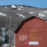
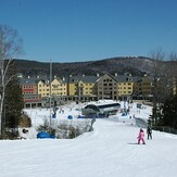
Ludlow Mountain Ski Slopes Behind The Loft Tavern, Vermont
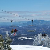
Chairlift Overlooking the Green Mountains from Ludlow Mountain
Jackson Gore Base Area at Okemo Mountain Resort, Ludlow