
– Lat/Long: 43.20° N 72.06° W
 Lovewell Mountain
Weather Forecast, United StatesIssued: 1 am Thu 16 Jul Local TimeUpdates in: hr min sUpdate imminent
Issued: 1 am Thu 16 Jul Local Time
Updates in:
Update imminent hr min s

Issued: 1 am Thu 16 Jul Local Time
Updates in:
Update imminent hr min s
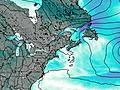
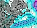
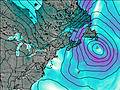
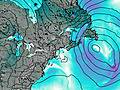
Days 1–3 Weather SummaryLight rain (total 3mm), mostly falling on Sat night. Warm (max 24°C on Sat afternoon, min 11°C on Thu night). Winds increasing (light winds from the WNW on Fri night, near gales from the W by Sat night). | Days 4–6 Weather SummaryModerate rain (total 10mm), heaviest on Tue night. Warm (max 21°C on Mon afternoon, min 9°C on Tue night). Winds increasing (light winds from the WSW on Mon afternoon, strong winds from the NNW by Tue night). | |||||||||||||||||
Thursday 16 | Friday 17 | Saturday 18 | Sunday 19 | Monday 20 | Tuesday 21 | |||||||||||||
AM | PM | night | AM | PM | night | AM | PM | night | AM | PM | night | AM | PM | night | AM | PM | night | |
clear | some clouds | clear | clear | clear | clear | clear | clear | rain shwrs | rain shwrs | clear | clear | clear | clear | some clouds | light rain | light rain | rain shwrs | |
km/h | ||||||||||||||||||
 |  |  |  |  |  | |||||||||||||
— | — | — | — | — | — | — | — | — | — | — | — | — | — | — | — | — | — | |
mm | — | — | — | — | — | — | — | — | 3 | 0.4 | — | — | — | — | — | 0.7 | 2 | 7 |
max °C | 21 | 22 | 18 | 17 | 20 | 18 | 20 | 24 | 20 | 17 | 16 | 15 | 16 | 21 | 18 | 18 | 17 | 14 |
min °C | 18 | 19 | 11 | 14 | 19 | 14 | 17 | 23 | 17 | 15 | 16 | 11 | 14 | 19 | 16 | 18 | 17 | 9 |
chill °C | 17 | 18 | 8 | 12 | 19 | 14 | 17 | 23 | 15 | 13 | 14 | 9 | 12 | 19 | 15 | 17 | 16 | 5 |
Freezing level m | 3150 | 3250 | 3700 | 3800 | 3750 | 3900 | 4000 | 4150 | 4200 | 3850 | 3500 | 3900 | 4250 | 4350 | 4300 | 3600 | 3650 | 3450 |
Cloud base (m) | 2600 | 5950 | 5600 | 300 | 400 | 1950 | 8850 | 6650 | 1450 | 550 | ||||||||
5:22 | — | — | 5:22 | — | — | 5:24 | — | — | 5:24 | — | — | 5:26 | — | — | 5:26 | — | — | |
— | — | 8:24 | — | — | 8:23 | — | — | 8:23 | — | — | 8:22 | — | — | 8:22 | — | — | 8:21 | |
Loading...
Lovewell Mountain Weather (Days 0-3):
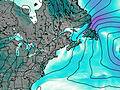
The weather forecast for Lovewell Mountain is: Light rain (total 3mm), mostly falling on Sat night. Warm (max 24°C on Sat afternoon, min 11°C on Thu night). Winds increasing (light winds from the WNW on Fri night, near gales from the W by Sat night).
Lovewell Mountain Weather (Days 3-6):
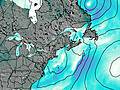
Moderate rain (total 10mm), heaviest on Tue night. Warm (max 21°C on Mon afternoon, min 9°C on Tue night). Winds increasing (light winds from the WSW on Mon afternoon, strong winds from the NNW by Tue night).
This table gives the weather forecast for Lovewell Mountain at the specific elevation of 754 m. Our advanced weather models allow us to provide distinct weather forecasts for several elevations of Lovewell Mountain. To see the weather forecasts for the other elevations, use the tab navigation above the table. For a wider overview of the weather, consult the Weather Map of New-Hampshire.