
– Lat/Long: 36.18° N 70.98° E
 Kuh-e Bandaka
Weather Forecast, AfghanistanIssued: 3 pm Mon 03 Aug Local TimeUpdates in: hr min sUpdate imminent
Issued: 3 pm Mon 03 Aug Local Time
Updates in:
Update imminent hr min s

Issued: 3 pm Mon 03 Aug Local Time
Updates in:
Update imminent hr min s
Days 1–4 Weather SummaryMostly dry. Temperatures will be well below freezing (max -6°C on Mon afternoon, min -13°C on Wed night). Winds decreasing (fresh winds from the WSW on Mon night, light winds from the W by Tue night). | Days 5–7 Weather SummaryMostly dry. Temperatures will be well below freezing (max -9°C on Sat afternoon, min -12°C on Thu night). Winds increasing (light winds from the WSW on Thu night, strong winds from the SW by Sun morning). | ||||||||||||||||
Mon 3 | Tuesday 4 | Wednesday 5 | Thursday 6 | Friday 7 | Saturday 8 | ||||||||||||
PM | night | AM | PM | night | AM | PM | night | AM | PM | night | AM | PM | night | AM | PM | night | |
some clouds | clear | some clouds | some clouds | clear | clear | clear | clear | clear | clear | clear | clear | clear | clear | some clouds | clear | some clouds | |
Cloud base (m) | 6050 | 5400 | 5350 | 5550 | 4950 | 6400 | 6150 | ||||||||||
km/h | |||||||||||||||||
 |  |  |  |  |  | ||||||||||||
— | — | — | — | — | — | — | — | — | — | — | — | — | — | — | — | — | |
mm | — | — | — | — | — | — | — | — | — | — | — | — | — | — | — | — | — |
max °C | -6 | -9 | -11 | -10 | -11 | -12 | -12 | -12 | -11 | -11 | -11 | -11 | -10 | -10 | -10 | -9 | -10 |
min °C | -8 | -11 | -11 | -11 | -12 | -12 | -12 | -13 | -12 | -11 | -12 | -11 | -11 | -11 | -10 | -9 | -10 |
chill °C | -15 | -22 | -21 | -20 | -18 | -19 | -20 | -20 | -20 | -19 | -19 | -19 | -18 | -20 | -21 | -19 | -19 |
Freezing level m | 5850 | 5150 | 5200 | 5250 | 4800 | 5100 | 5250 | 4750 | 5150 | 5400 | 4950 | 5300 | 5500 | 5150 | 5450 | 5600 | 5350 |
— | — | 4:54 | — | — | 4:54 | — | — | 4:56 | — | — | 4:56 | — | — | 4:58 | — | — | |
6:49 | — | — | 6:47 | — | — | 6:46 | — | — | 6:45 | — | — | 6:45 | — | — | 6:44 | — | |
Loading...
Kuh-e Bandaka Weather (Days 0-3):
The weather forecast for Kuh-e Bandaka is: Mostly dry. Temperatures will be well below freezing (max -6°C on Mon afternoon, min -13°C on Wed night). Winds decreasing (fresh winds from the WSW on Mon night, light winds from the W by Tue night).
Kuh-e Bandaka Weather (Days 3-6):
Mostly dry. Temperatures will be well below freezing (max -9°C on Sat afternoon, min -12°C on Thu night). Winds increasing (light winds from the WSW on Thu night, strong winds from the SW by Sun morning).
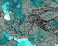
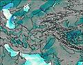
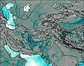
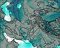
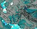
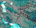
This table gives the weather forecast for Kuh-e Bandaka at the specific elevation of 6812 m. Our advanced weather models allow us to provide distinct weather forecasts for several elevations of Kuh-e Bandaka. To see the weather forecasts for the other elevations, use the tab navigation above the table. For a wider overview of the weather, consult the Weather Map of Afghanistan.
| Weather Station | Temp. | Weather | Wind | Gusts | Cloud / Visibility |
|---|---|---|---|---|---|
Peshawar Airport | |||||
* NOTE: not all weather observatories update at the same frequency which is the reason why some locations may show data from stations that are further away than known closer ones.