
– Lat/Long: 34.16° N 75.33° E
 Kolhoi Peak
Weather Forecast, IndiaIssued: 4 pm Mon 03 Aug Local TimeUpdates in: hr min sUpdate imminent
Issued: 4 pm Mon 03 Aug Local Time
Updates in:
Update imminent hr min s

Issued: 4 pm Mon 03 Aug Local Time
Updates in:
Update imminent hr min s
Days 1–4 Weather SummaryModerate rain (total 14mm), heaviest on Tue afternoon. Very mild (max 13°C on Wed afternoon, min 8°C on Tue night). Wind will be generally light. | Days 5–7 Weather SummaryLight rain (total 5mm), mostly falling on Fri afternoon. Very mild (max 13°C on Sat morning, min 8°C on Thu night). Wind will be generally light. | ||||||||||||||||
Mon 3 | Tuesday 4 | Wednesday 5 | Thursday 6 | Friday 7 | Saturday 8 | ||||||||||||
PM | night | AM | PM | night | AM | PM | night | AM | PM | night | AM | PM | night | AM | PM | night | |
risk tstorm | rain shwrs | rain shwrs | risk tstorm | rain shwrs | some clouds | risk tstorm | rain shwrs | rain shwrs | risk tstorm | rain shwrs | rain shwrs | risk tstorm | rain shwrs | clear | risk tstorm | clear | |
Cloud base (m) | 4500 | 5950 | 4450 | 6550 | 5150 | 5100 | 5250 | 6150 | 5750 | 4700 | 4750 | ||||||
km/h | |||||||||||||||||
 |  |  |  |  |  | ||||||||||||
— | — | — | — | — | — | — | — | — | — | — | — | — | — | — | — | — | |
mm | 4 | 1.2 | 3 | 5 | 0.1 | — | 1.4 | 0.6 | 0.2 | 1.1 | 0.5 | 0.2 | 1.8 | 0.1 | — | 1.2 | — |
max °C | 12 | 11 | 11 | 11 | 10 | 12 | 13 | 9 | 11 | 12 | 9 | 12 | 12 | 10 | 13 | 13 | 11 |
min °C | 12 | 9 | 10 | 10 | 8 | 10 | 12 | 8 | 10 | 12 | 8 | 9 | 12 | 8 | 10 | 13 | 9 |
chill °C | 11 | 9 | 9 | 9 | 8 | 8 | 10 | 7 | 8 | 10 | 8 | 7 | 11 | 8 | 9 | 12 | 8 |
Freezing level m | 5900 | 5650 | 5800 | 5800 | 5550 | 5850 | 5900 | 5500 | 5750 | 5800 | 5350 | 5750 | 5850 | 5550 | 5850 | 5950 | 5650 |
— | — | 5:41 | — | — | 5:41 | — | — | 5:43 | — | — | 5:43 | — | — | 5:43 | — | — | |
7:28 | — | — | 7:27 | — | — | 7:25 | — | — | 7:24 | — | — | 7:23 | — | — | 7:22 | — | |
Loading...
Kolhoi Peak Weather (Days 0-3):
The weather forecast for Kolhoi Peak is: Moderate rain (total 14mm), heaviest on Tue afternoon. Very mild (max 13°C on Wed afternoon, min 8°C on Tue night). Wind will be generally light.
Kolhoi Peak Weather (Days 3-6):
Light rain (total 5mm), mostly falling on Fri afternoon. Very mild (max 13°C on Sat morning, min 8°C on Thu night). Wind will be generally light.
This table gives the weather forecast for Kolhoi Peak at the specific elevation of 4000 m. Our advanced weather models allow us to provide distinct weather forecasts for several elevations of Kolhoi Peak. To see the weather forecasts for the other elevations, use the tab navigation above the table. For a wider overview of the weather, consult the Weather Map of India.
* NOTE: not all weather observatories update at the same frequency which is the reason why some locations may show data from stations that are further away than known closer ones.
Kolhoi Peak Photos
View all
Punjab Himalaya photos (21) |
Greater Himalaya photos (384) |
photos from mountains in India (87) |
all photos
 Upload new photo
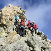

final summit ridge
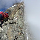
the last 300 ft and the Chief Gendarme
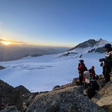
sunrise above kolahoi glacier
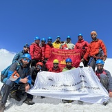
summit team kolahoi peak 5431m
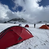
advance summit camp Kolahoi Glacier
summit team photo