
– Lat/Long: 60.58° N 140.65° W
 King Peak
Weather Forecast, CanadaIssued: 10 am Tue 14 Jul Local TimeUpdates in: hr min sUpdate imminent
Issued: 10 am Tue 14 Jul Local Time
Updates in:
Update imminent hr min s

Issued: 10 am Tue 14 Jul Local Time
Updates in:
Update imminent hr min s
Days 1–3 Weather SummaryA heavy fall of snow, heaviest during Tue night. Extremely cold (max -11°C on Tue afternoon, min -19°C on Wed night). Winds increasing (fresh winds from the W on Tue morning, gales from the W by Wed night). | Days 4–6 Weather SummaryA moderate fall of snow, heaviest on Fri afternoon. Extremely cold (max -11°C on Sun night, min -20°C on Fri night). Mainly strong winds. | |||||||||||||||||
Tuesday 14 | Wednesday 15 | Thursday 16 | Friday 17 | Saturday 18 | Sunday 19 | |||||||||||||
AM | PM | night | AM | PM | night | AM | PM | night | AM | PM | night | AM | PM | night | AM | PM | night | |
some clouds | cloudy | heavy snow | some clouds | snow shwrs | snow shwrs | cloudy | cloudy | light snow | mod. snow | snow shwrs | clear | clear | clear | some clouds | some clouds | clear | clear | |
km/h | ||||||||||||||||||
 |  |  |  |  |  | |||||||||||||
— | — | 12 | — | 4 | 3 | — | — | 5 | 7 | 11 | — | — | — | — | — | — | — | |
mm | — | — | — | — | — | — | — | — | — | — | — | — | — | — | — | — | — | — |
max °C | -12 | -11 | -12 | -15 | -16 | -16 | -15 | -13 | -12 | -14 | -15 | -17 | -19 | -16 | -13 | -13 | -12 | -11 |
min °C | -13 | -12 | -15 | -15 | -17 | -19 | -15 | -14 | -13 | -14 | -16 | -20 | -20 | -18 | -15 | -13 | -13 | -12 |
chill °C | -23 | -23 | -30 | -29 | -33 | -35 | -30 | -26 | -24 | -26 | -30 | -33 | -33 | -30 | -28 | -24 | -25 | -24 |
Freezing level m | 2900 | 3300 | 2650 | 2500 | 2300 | 1550 | 2300 | 2700 | 2950 | 2750 | 2550 | 2050 | 2050 | 2150 | 1850 | 2750 | 2800 | 2950 |
Cloud base (m) | 2550 | 2600 | 2550 | 2550 | 2550 | 2550 | 2550 | 2550 | 2550 | 2550 | 2550 | 2550 | 2550 | 2600 | 2750 | 2550 | 2550 | |
5:18 | — | — | 5:20 | — | — | 5:22 | — | — | 5:24 | — | — | 5:26 | — | — | 5:28 | — | — | |
— | — | 11:37 | — | — | 11:35 | — | — | 11:32 | — | — | 11:30 | — | — | 11:29 | — | — | 11:27 | |
Loading...
King Peak Weather (Days 0-3):
The weather forecast for King Peak is: A heavy fall of snow, heaviest during Tue night. Extremely cold (max -11°C on Tue afternoon, min -19°C on Wed night). Winds increasing (fresh winds from the W on Tue morning, gales from the W by Wed night).
King Peak Weather (Days 3-6):
A moderate fall of snow, heaviest on Fri afternoon. Extremely cold (max -11°C on Sun night, min -20°C on Fri night). Mainly strong winds.
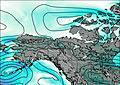
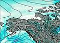
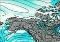
This table gives the weather forecast for King Peak at the specific elevation of 5173 m. Our advanced weather models allow us to provide distinct weather forecasts for several elevations of King Peak. To see the weather forecasts for the other elevations, use the tab navigation above the table. For a wider overview of the weather, consult the Weather Map of Yukon-Territory.
| Weather Station | Temp. | Weather | Wind | Gusts | Cloud / Visibility |
|---|---|---|---|---|---|
SHIP7554 | |||||
BUOY-ICYA2 | |||||
Burwash Airport | |||||
BUOY-YATA2 | |||||
Yakutat Airport | |||||
Haines Junction- YT | |||||
Haines Junction Airport | |||||
Cape Suckling Buoy | |||||
Beaver Creek Airport | |||||
BUOY-ELXA2 |
* NOTE: not all weather observatories update at the same frequency which is the reason why some locations may show data from stations that are further away than known closer ones.