
– Lat/Long: 41.08° N 126.50° E
 Kangnam Mountains
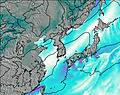
Weather Forecast, Korea NIssued: 8 pm Mon 03 Aug Local TimeUpdates in: hr min sUpdate imminent
Issued: 8 pm Mon 03 Aug Local Time
Updates in:
Update imminent hr min s

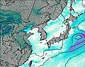
Issued: 8 pm Mon 03 Aug Local Time
Updates in:
Update imminent hr min s
Days 1–4 Weather SummaryMostly dry. Warm (max 37°C on Thu afternoon, min 25°C on Mon night). Wind will be generally light. | Days 5–7 Weather SummaryHeavy rain (total 28mm), heaviest during Fri night. Warm (max 34°C on Fri afternoon, min 22°C on Sat night). Wind will be generally light. | |||||||||||||||
Tuesday 4 | Wednesday 5 | Thursday 6 | Friday 7 | Saturday 8 | ||||||||||||
night | AM | PM | night | AM | PM | night | AM | PM | night | AM | PM | night | AM | PM | night | |
risk tstorm | clear | clear | clear | clear | clear | clear | clear | clear | risk tstorm | risk tstorm | rain shwrs | risk tstorm | risk tstorm | risk tstorm | risk tstorm | |
Cloud base (m) | 9750 | 9650 | 5100 | 4600 | 5550 | 500 | 400 | |||||||||
km/h | ||||||||||||||||
 |  | 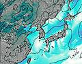 | 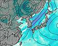 |  |  | |||||||||||
— | — | — | — | — | — | — | — | — | — | — | — | — | — | — | — | |
mm | 0.1 | — | — | — | — | — | — | — | — | 3 | 1.3 | 0.2 | 7 | 4 | 1.7 | 0.8 |
max °C | 28 | 33 | 35 | 29 | 33 | 36 | 30 | 34 | 37 | 29 | 32 | 34 | 27 | 24 | 25 | 24 |
min °C | 25 | 29 | 34 | 25 | 29 | 35 | 25 | 30 | 35 | 26 | 27 | 32 | 23 | 24 | 25 | 22 |
chill °C | 25 | 29 | 34 | 25 | 29 | 35 | 25 | 30 | 35 | 26 | 27 | 32 | 23 | 24 | 25 | 22 |
Freezing level m | 5600 | 5500 | 5500 | 5450 | 5400 | 5500 | 5500 | 5450 | 5500 | 5350 | 5150 | 5200 | 5050 | 4850 | 4800 | 4700 |
— | 5:31 | — | — | 5:33 | — | — | 5:33 | — | — | 5:35 | — | — | 5:35 | — | — | |
— | — | 7:46 | — | — | 7:45 | — | — | 7:45 | — | — | 7:43 | — | — | 7:42 | — | |
Loading...
Kangnam Mountains Weather (Days 0-3):
The weather forecast for Kangnam Mountains is: Mostly dry. Warm (max 37°C on Thu afternoon, min 25°C on Mon night). Wind will be generally light.
Kangnam Mountains Weather (Days 3-6):
Heavy rain (total 28mm), heaviest during Fri night. Warm (max 34°C on Fri afternoon, min 22°C on Sat night). Wind will be generally light.
This table gives the weather forecast for Kangnam Mountains at the specific elevation of 200 m. Our advanced weather models allow us to provide distinct weather forecasts for several elevations of Kangnam Mountains. To see the weather forecasts for the other elevations, use the tab navigation above the table. For a wider overview of the weather, consult the Weather Map of North Korea.