– Lat/Long: 61.46° N 7.91° E
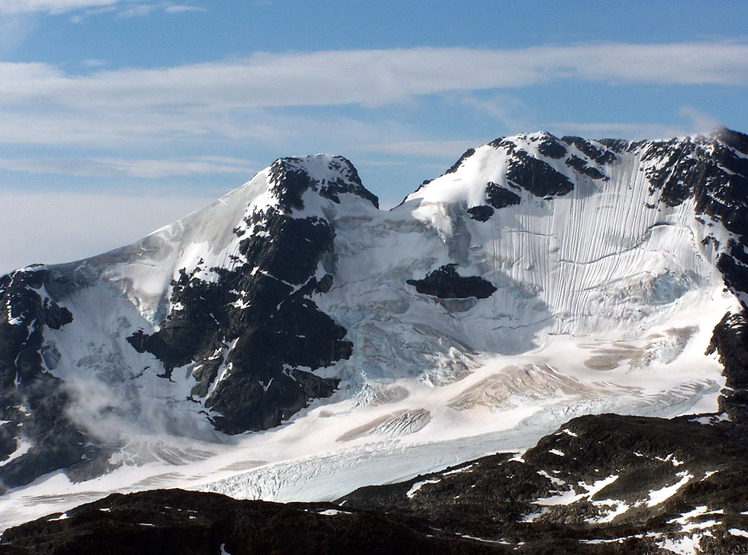
 Jervvasstind
Weather Forecast, NorwayIssued: 1 pm Thu 23 Jul Local TimeUpdates in: hr min sUpdate imminent
Issued: 1 pm Thu 23 Jul Local Time
Updates in:
Update imminent hr min s

Issued: 1 pm Thu 23 Jul Local Time
Updates in:
Update imminent hr min s
Days 1–4 Weather SummaryLight rain (total 8mm), mostly falling on Sat night. Very mild (max 10°C on Thu afternoon, min 1°C on Sat night). Wind will be generally light. | Days 5–7 Weather SummaryA dusting of snow on Mon morning. Freezing level rising with drizzle on Mon afternoon. Freeze-thaw conditions (max 7°C on Tue night, min 0°C on Mon night). Wind will be generally light. | ||||||||||||||||
Thu 23 | Friday 24 | Saturday 25 | Sunday 26 | Monday 27 | Tuesday 28 | ||||||||||||
PM | night | AM | PM | night | AM | PM | night | AM | PM | night | AM | PM | night | AM | PM | night | |
some clouds | some clouds | light rain | light rain | light rain | light rain | light rain | light rain | cloudy | rain shwrs | cloudy | snow shwrs | rain shwrs | some clouds | cloudy | cloudy | cloudy | |
Cloud base (m) | 3100 | 2250 | 850 | 850 | 1650 | 1400 | 1400 | 1500 | 1400 | 1700 | 1400 | 1400 | 1750 | 2050 | 900 | 1950 | 1650 |
km/h | |||||||||||||||||
 |  |  |  |  |  | ||||||||||||
— | — | — | — | — | — | — | — | — | — | — | 1 | — | — | — | — | — | |
mm | — | — | 0.5 | 0.8 | 0.6 | 1.3 | 0.4 | 4 | — | 0.3 | — | — | 0.6 | — | — | — | — |
max °C | 10 | 9 | 4 | 4 | 4 | 4 | 6 | 5 | 1 | 3 | 1 | 2 | 4 | 3 | 2 | 6 | 7 |
min °C | 10 | 4 | 3 | 4 | 3 | 4 | 5 | 1 | 1 | 2 | 1 | 1 | 2 | 0 | 1 | 3 | 6 |
chill °C | 9 | 1 | 0 | 1 | 0 | 1 | 2 | -3 | -3 | -2 | -3 | -2 | -1 | -3 | -2 | 0 | 4 |
Freezing level m | 2800 | 2500 | 2250 | 2400 | 2700 | 2250 | 2600 | 1950 | 1700 | 1850 | 1700 | 1750 | 2050 | 1800 | 1900 | 2600 | 3200 |
— | — | 4:35 | — | — | 4:39 | — | — | 4:41 | — | — | 4:43 | — | — | 4:46 | — | — | |
— | 10:32 | — | — | 10:30 | — | — | 10:28 | — | — | 10:25 | — | — | 10:22 | — | — | 10:21 | |
Loading...
Jervvasstind Weather (Days 0-3):
The weather forecast for Jervvasstind is: Light rain (total 8mm), mostly falling on Sat night. Very mild (max 10°C on Thu afternoon, min 1°C on Sat night). Wind will be generally light.
Jervvasstind Weather (Days 3-6):
A dusting of snow on Mon morning. Freezing level rising with drizzle on Mon afternoon. Freeze-thaw conditions (max 7°C on Tue night, min 0°C on Mon night). Wind will be generally light.
This table gives the weather forecast for Jervvasstind at the specific elevation of 1500 m. Our advanced weather models allow us to provide distinct weather forecasts for several elevations of Jervvasstind. To see the weather forecasts for the other elevations, use the tab navigation above the table. For a wider overview of the weather, consult the Weather Map of Norway.
| Weather Station | Temp. | Weather | Wind | Gusts | Cloud / Visibility |
|---|---|---|---|---|---|
Filefjell | |||||
Modvaberget | |||||
Brata -Slettom | |||||
Tylderingen | |||||
Sogndal AP | |||||
Beitostolen II | |||||
Grotli III |
* NOTE: not all weather observatories update at the same frequency which is the reason why some locations may show data from stations that are further away than known closer ones.
Jervvasstind Photos
View all
Scandinavia/European Arctic Ranges photos (16) |
photos from mountains in Norway (115) |
all photos
 Upload new photo
Jervvasstind