– Lat/Long: 48.81° N 113.76° W
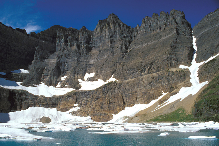
 Iceberg Peak (Montana)
Weather Forecast, United StatesIssued: 11 pm Tue 21 Jul Local TimeUpdates in: hr min sUpdate imminent
Issued: 11 pm Tue 21 Jul Local Time
Updates in:
Update imminent hr min s

Issued: 11 pm Tue 21 Jul Local Time
Updates in:
Update imminent hr min s
Days 1–4 Weather SummaryMostly dry. Warm (max 24°C on Thu afternoon, min 14°C on Thu night). Winds increasing (calm on Tue night, strong winds from the WSW by Fri afternoon). | Days 5–7 Weather SummaryMostly dry. Warm (max 23°C on Sat afternoon, min 8°C on Sun night). Mainly strong winds. | ||||||||||||||||||
Wednesday 22 | Thursday 23 | Friday 24 | Saturday 25 | Sunday 26 | Monday 27 | ||||||||||||||
night | AM | PM | night | AM | PM | night | AM | PM | night | AM | PM | night | AM | PM | night | AM | PM | night | |
risk tstorm | clear | clear | clear | some clouds | clear | rain shwrs | clear | clear | clear | clear | clear | clear | clear | clear | clear | clear | clear | clear | |
Cloud base (m) | 8950 | 4550 | 4800 | 6300 | |||||||||||||||
km/h | |||||||||||||||||||
 |  |  |  |  |  |  | |||||||||||||
— | — | — | — | — | — | — | — | — | — | — | — | — | — | — | — | — | — | — | |
mm | 0.1 | — | — | — | — | — | 0.1 | — | — | — | — | — | — | — | — | — | — | — | — |
max °C | 16 | 21 | 23 | 20 | 22 | 24 | 21 | 19 | 23 | 19 | 21 | 23 | 18 | 15 | 17 | 13 | 12 | 16 | 13 |
min °C | 15 | 19 | 22 | 17 | 20 | 24 | 14 | 17 | 23 | 16 | 19 | 22 | 12 | 14 | 17 | 8 | 10 | 15 | 11 |
chill °C | 15 | 19 | 22 | 17 | 20 | 24 | 12 | 16 | 23 | 15 | 18 | 22 | 9 | 12 | 15 | 3 | 6 | 14 | 10 |
Freezing level m | 4800 | 4650 | 4850 | 4900 | 4750 | 4900 | 4800 | 4650 | 4850 | 4700 | 4700 | 4850 | 4650 | 4300 | 4200 | 3900 | 3800 | 3900 | 4250 |
— | 5:54 | — | — | 5:56 | — | — | 5:56 | — | — | 5:58 | — | — | 6:00 | — | — | 6:01 | — | — | |
— | — | — | 9:25 | — | — | 9:24 | — | — | 9:23 | — | — | 9:22 | — | — | 9:22 | — | — | 9:20 | |
Loading...
Iceberg Peak (Montana) Weather (Days 0-3):
The weather forecast for Iceberg Peak (Montana) is: Mostly dry. Warm (max 24°C on Thu afternoon, min 14°C on Thu night). Winds increasing (calm on Tue night, strong winds from the WSW by Fri afternoon).
Iceberg Peak (Montana) Weather (Days 3-6):
Mostly dry. Warm (max 23°C on Sat afternoon, min 8°C on Sun night). Mainly strong winds.
This table gives the weather forecast for Iceberg Peak (Montana) at the specific elevation of 2000 m. Our advanced weather models allow us to provide distinct weather forecasts for several elevations of Iceberg Peak (Montana). To see the weather forecasts for the other elevations, use the tab navigation above the table. For a wider overview of the weather, consult the Weather Map of Montana.
| Weather Station | Temp. | Weather | Wind | Gusts | Cloud / Visibility |
|---|---|---|---|---|---|
Waterton Park Gate- Alta | |||||
Carway- Alta | |||||
Bullhorn Headwaters- Alta | |||||
Cardston- Alta | |||||
Glenwood- Alta | |||||
Bullhorn Coulee Reservoir- Alta | |||||
* NOTE: not all weather observatories update at the same frequency which is the reason why some locations may show data from stations that are further away than known closer ones.
Iceberg Peak (Montana) Photos
View all
Central Montana Rockies photos (3) |
Rocky Mountains (USA) photos (298) |
photos from mountains in United States (3056) |
all photos
 Upload new photo
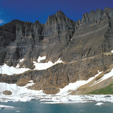
Iceberg Peak (Montana)