– Lat/Long: 43.75° N 114.13° W
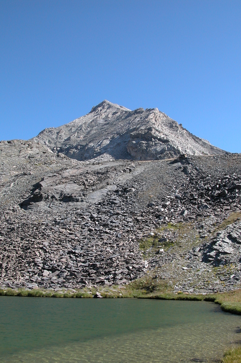
 Hyndman Peak
Weather Forecast, United StatesIssued: 5 am Mon 03 Aug Local TimeUpdates in: hr min sUpdate imminent
Issued: 5 am Mon 03 Aug Local Time
Updates in:
Update imminent hr min s

Issued: 5 am Mon 03 Aug Local Time
Updates in:
Update imminent hr min s
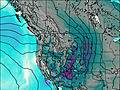
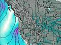
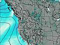
Days 1–3 Weather SummaryMostly dry. Warm (max 26°C on Wed afternoon, min 14°C on Mon night). Wind will be generally light. | Days 4–6 Weather SummaryMostly dry. Warm (max 29°C on Thu afternoon, min 21°C on Fri night). Winds decreasing (strong winds from the WSW on Fri afternoon, calm by Fri night). | |||||||||||||||||
Monday 3 | Tuesday 4 | Wednesday 5 | Thursday 6 | Friday 7 | Saturday 8 | |||||||||||||
AM | PM | night | AM | PM | night | AM | PM | night | AM | PM | night | AM | PM | night | AM | PM | night | |
clear | clear | clear | clear | clear | clear | clear | clear | clear | clear | clear | clear | clear | clear | clear | clear | clear | clear | |
Cloud base (m) | 9350 | 9400 | 6050 | 6200 | ||||||||||||||
km/h | ||||||||||||||||||
 |  |  |  |  |  | |||||||||||||
— | — | — | — | — | — | — | — | — | — | — | — | — | — | — | — | — | — | |
mm | — | — | — | — | — | — | — | — | — | — | — | — | — | — | — | — | — | — |
max °C | 19 | 22 | 19 | 20 | 24 | 19 | 23 | 26 | 22 | 26 | 29 | 25 | 28 | 29 | 22 | 27 | 28 | 23 |
min °C | 16 | 22 | 14 | 17 | 23 | 17 | 20 | 26 | 20 | 23 | 29 | 23 | 26 | 28 | 21 | 24 | 28 | 21 |
chill °C | 16 | 22 | 14 | 17 | 23 | 17 | 20 | 26 | 20 | 23 | 29 | 23 | 26 | 28 | 21 | 24 | 28 | 21 |
Freezing level m | 4300 | 4800 | 4650 | 4450 | 4900 | 4800 | 4750 | 5200 | 5100 | 5100 | 5450 | 5350 | 5300 | 5400 | 5250 | 5150 | 5350 | 5200 |
6:26 | — | — | 6:28 | — | — | 6:28 | — | — | 6:30 | — | — | 6:31 | — | — | 6:31 | — | — | |
— | 8:57 | — | — | 8:55 | — | — | 8:54 | — | — | 8:52 | — | — | 8:52 | — | — | 8:51 | — | |
Loading...
Hyndman Peak Weather (Days 0-3):
The weather forecast for Hyndman Peak is: Mostly dry. Warm (max 26°C on Wed afternoon, min 14°C on Mon night). Wind will be generally light.
Hyndman Peak Weather (Days 3-6):
Mostly dry. Warm (max 29°C on Thu afternoon, min 21°C on Fri night). Winds decreasing (strong winds from the WSW on Fri afternoon, calm by Fri night).
This table gives the weather forecast for Hyndman Peak at the specific elevation of 2000 m. Our advanced weather models allow us to provide distinct weather forecasts for several elevations of Hyndman Peak. To see the weather forecasts for the other elevations, use the tab navigation above the table. For a wider overview of the weather, consult the Weather Map of Idaho.
| Weather Station | Temp. | Weather | Wind | Gusts | Cloud / Visibility |
|---|---|---|---|---|---|
Stanley Airport | |||||
Challis Airport | |||||
Twin Falls Airport | |||||
Salmo / emhi County Airport | |||||
Mountain Home Airport |
* NOTE: not all weather observatories update at the same frequency which is the reason why some locations may show data from stations that are further away than known closer ones.
Hyndman Peak Photos
View all
Bitterroot Range photos (11) |
Rocky Mountains (USA) photos (298) |
photos from mountains in United States (3056) |
all photos
 Upload new photo
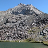
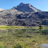
Hyndman Peak
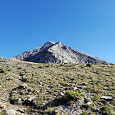
Hyndman
Hyndman
Hyndman
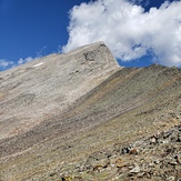
Summit
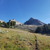
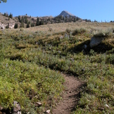
Trail to the saddle
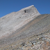
Hyndman Peak Ridgeline